
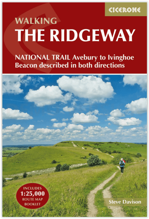
Wandelgids Ridgeway National Trail - Cicerone
Avebury in Wiltshire to Ivinghoe Beacon in Buckinghamshire
Korte omschrijving
Wandelgids The Ridgeway National Trail 139 km - Cicerone Productomschrijving: Gids voor de beroemde Ridgeway National Trail, een route van 139 km door het zuiden van Engeland, van Avebury in...

Specificaties
- Uitgever: CICERONE Press
- ISBN-13: 9781852848743
- HOOFDCATEGORIEËN: Wandelgids
- Activiteiten: Wandelen, Hiking & Trekking
- Auteur: Steve Davison
- Regio: South & South East England
- Land: England
- Lange afstand wandelroutes: Ridgeway National Trail (139 km)
- AONB - Area of Outstanding Beauty: Chiltern Hills AONB, North Wessex Downs AONB
- Blz.: 208
- Afmeting: 12x17
- Editie: 2
- Taal: Engels
Volledige omschrijving
Wandelgids The Ridgeway National Trail 139 km - Cicerone
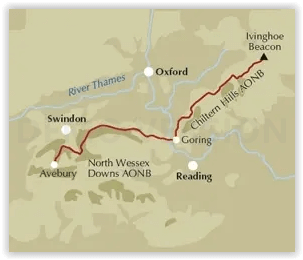
Productomschrijving: Gids voor de beroemde Ridgeway National Trail, een route van 139 km door het zuiden van Engeland, van Avebury in Wiltshire naar Ivinghoe Beacon in Buckinghamshire. Deze gids, die vergezeld gaat van een 1:25K kaartboekje, beschrijft de route in beide richtingen en bevat informatie over historische plaatsen en faciliteiten langs de route.
Engelse omschrijving: Guidebook to the Ridgeway National Trail, an 87 mile (139km) route through the south of England from Avebury in Wiltshire to Ivinghoe Beacon in Buckinghamshire. Accompanied by a pull-out 1:25K mapping booklet, this guidebook details the trail in both directions and features information on historic sites and facilities along the way.
Seasons:
Scan be undertaken at any time of the year, although the weather and ground conditions are better from spring through to the end of autumn (from colourful displays of flowers in spring to the dramatic tree colours of autumn); a frosty or snowy day on the Ridgeway can be magical - but daylight hours are shorter.
Centres:
Avebury, Swindon, Marlborough, Wantage, Streatley, Goring, Wallingford, Watlington, Chinnor, Princes Risborough, Wendover and Tring.
Difficulty:
A fairly low-level (never going above 300m) waymarked walk that follows mostly good tracks and paths, suitable for all abilities.
Must See:
Two contrasting AONBs: the wide open, chalky North Wessex Downs and the more wooded, intimate landscape of the Chilterns; the stone circle at Avebury to Wayland's Smithy Neolithic burial mound and the Uffington White Horse; great views, short excursions to picturesque towns and villages.
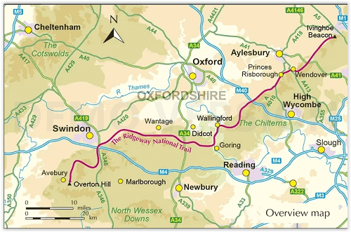
Stage 1 Overton Hill (Avebury) to Ogbourne St George
Stage 2 Ogbourne St George to Ashbury Folly
Stage 3 Ashbury Folly to the A338 (Wantage/Court Hill Centre)
Stage 4 A338 (Wantage/Court Hill Centre) to Bury Down
Stage 5 Bury Down to Streatley
Stage 6 Streatley to Mongewell Park
Stage 7 Mongewell Park to Watlington
Stage 8 Watlington to Chinnor
Stage 9 Chinnor to Princes Risborough
Stage 10 Princes Risborough to Wendover
Stage 11 Wendover to Wigginton
Stage 12 Wigginton to Ivinghoe Beacon
The Ridgeway (East to West)
Stage 1 Ivinghoe Beacon to Wigginton
Stage 2 Wigginton to Wendover
Stage 3 Wendover to Princes Risborough
Stage 4 Princes Risborough to Chinnor
Stage 5 Chinnor to Watlington
Stage 6 Watlington to Mongewell Park
Stage 7 Mongewell Park to Streatley
Stage 8 Streatley to Bury Down
Stage 9 Bury Down to the A338 (Wantage/Court Hill Centre)
Stage 10 A338 (Wantage/Court Hill Centre) to Ashbury Folly
Stage 11 Ashbury Folly to Ogbourne St George
Stage 12 Ogbourne St George to Overton Hill (Avebury)
Locatie op kaart
Overzichtskaarten

Area's of Outstanding Natural Beauty - AONB's UK
Area's of Outstanding Natural Beauty - AONB's UK

Producten op de overzichtskaart
Klik op een product om naar de detailpagina te gaan.
- Wandelgids - Guide to the Cotswolds AONB - AA
- Wandelkaart 24 - Chilterns AONB - AA
- Fietskaart- en Mtb kaart - The Cotswolds - Goldeneye
- Wandelgids - Cotswold classic walks guidebook - Goldeneye
- Wandelgids - Exploring the Cotswolds - Goldeneye
- Wandelgids - Cotswold Classic Walks - Goldeneye
- Wandelkaart - Cotswolds- Malverns & Forest of Dean - Goldeneye
- Wandelgids - The Cotswold Way 30 classic routes - Cicerone
- Wandelgids - Kent walking guide - Cicerone
- Wandelgids - North Downs Way Nat. trail - Cicerone
- Wandelgids - Chilterns walking guide - Cicerone
- Wandelgids - Suffolk coast & Heaths walks - Cicerone
- Wandelgids - North Downs Way - Map Booklet - Cicerone
- Wandelgids - North Pennines AONB walking guide - Cicerone
- Wandelgids - Ridgeway National Trail - Cicerone
- Wandelgids - Forest of Bowland & Pendle - Cicerone
- Wandelgids - Hampshire's Test Way walking guide - Cicerone
- Wandelgids & Fietsgids - The Cotswold AONB - Cicerone
- Wandelgids - Walking on the Gower - Cicerone
- Wandelgids - North Wessex Downs - Cicerone Press
- Wandelgids - Walking on the North Wessex Downs - Cicerone
- Wandelgids - Silverdale & Arnside AONB - Cicerone
- Wandelgids - North Downs Way- 246 km - Trailblazer
- Wandelkaart OL2 - Yorkshire Dales- Southern & Western Areas - OSI
- Wandelkaart OL19 - Howgill Fells and Upper Eden Valley - OSI
- Wandelkaart OL21 - South Pennines - Yorkshire - OSI
- Wandelkaart OL31 - North Pennines- Teesdale & Weardale - OSI
- Wandelkaart OL40 - The Broads - OSI
- Wandelkaart OL41 - Forest of Bowland & Ribblesdale - OSI
- Wandelkaart OL45 - The Cotswolds AONB- Gloucestershire - OSI
- Wandelkaart 108 - Lower Tamer Valley & Plymouth- Cornwall- OSI
- Wandelkaart 115 - Exmouth & Sidmouth- Devon - OSI
- Wandelkaart 137 - Ashford- Kent downs AONB- England - OSI
- Wandelkaart 140 - Quantock Hills AONB- Somerset - OSI
- Wandelkaart 140 - Quantock Hills AONB & Bridgwater- Devon - OSI
- Wandelkaart 147 - Sevenoaks & Tonbridge- Kent - OSI
- Wandelkaart 164 - Gower AONB & Gwyr- South Wales - OSI
- Wandelkaart 164 - Gower AONB & Gwyr- Wales - OSI
- Wandelkaart 171 - Chiltern Hills West & Henley-on-Thames OSI
- Wandelkaart 171 - Chiltern Hills West AONB- Wycombe - OSI
- Wandelkaart 172 - Chiltern Hills East AONB- Wycombe - OSI
- Wandelkaart 181 - Chiltern Hills AONB North- England - OSI
- Wandelkaart 181 - Chiltern Hills North AONB- Wycombe - OSI
- Wandelkaart 190 - Malvern Hills & Bredon Hill - OSI
- Wandelkaart 190 - Malvern Hills AONB & Bredon Hill - OSI
- Wandelkaart 203 - Ludlow- Shropshire Hills AONB - OSI
- Wandelkaart 217 - Long Mynd & Wenlock Edge- Schropshire- OSI
- Wandelkaart 254 - Lleyn Peninsular East- North Wales - OSI
- Wandelkaart 261 - Boston- Lincolnshire AONB - OSI
- Wandelkaart 262 - Anglesey West- Wales AONB - OSI
- Wandelkaart 263 - Anglesey East AONB- Wales - OSI
- Wandelkaart 273 - Lincolnshire Wolds South AONB - OSI
- Wandelkaart 282 - Lincolnshire Wolds North AONB - OSI
- Wandelkaart 298 - Nidderdale AONB- Yorkshire - OSI
- Wandelkaart 298 - Nidderdale AONB North Yorkshire - OSI
- Wandelkaart 300 - Howardian Hills AONB - OSI
- Wandelkaart 300 - Howardian Hills AONB & Malton - OSI
- Wandelkaart - Mourne Mountains N. Ireland - Harvey maps
- Wandelkaart - Fietskaart Forest of Bowland - Harvey maps
- Wandelkaart XT40 - Anglesey Coastal Path N. Wales - Harvey Maps
- Wandelkaart XT40 - Pennine Way Noord - Harvey Maps
- Wandelkaart XT40 - Pennine Way Zuid - Harvey Maps
- Wandelgids Cotswold - Way Two-way trekking guide - Knife Edge
- Reisgids Oxford & the Cotswolds AONB - Edicola
- Reisgids Cotswolds England - Rough Guides
- Travelguide Oxford & The Cotswolds pocket guide - Lonely Planet
- Wandelgids - The Ridgeway National trail - Trailblazer
Artikelen uit dezelfde regio

Wandelkaart OL22 New Forest- Southampton & Ringwood - OSI • 9780319475782
Wandelkaart New Forest national park - Southampton - OSI Productomschrijving: Kaart nummer OL22 in de OS Explorer kaartenserie is de perfecte kaart voor vakantiegangers en dagjesmensen om te gebruiken bij een bezoek aan het New Forest Nationaal Park in West Engeland. Het nationale park is beroemd om zijn uitstekende wandelingen en ritten en is de thuisbasis van New Forest pony's en heidela…

Wandelgids The Kennet and Avon Canal walk - Cicerone • 9781786312303
The Kennet and Avon Canal walk - Cicerone Productomschrijving: Wandelgids langs het Kennet & Avon kanaal. De 151 Km lange route van Reading naar Bristol is verdeeld in 7 etappes van redelijk gemakkelijke wandelingen en omvat het UNESCO werelderfgoed Bath en de drijvende haven van Bristol. Er zijn ook 20 rondwandelingen opgenomen, variërend van 4¼ tot 9 mijl, waarbij de beste delen van het …

Wandelgids Part 1 South West Coast Path Map Booklet - Cicerone • 9781786312181
Wandelgids Part 1 South West Coast Path Map Booklet - Cicerone Productomschrijving: Kaart boekje van het noordelijke deel (deel 3) van het 630 mijl (1014 km) lange South West Coast Path National Trail. Omvat het pad van Minehead tot St Ives langs de kustlijn van Noord-Devon en Cornwall. Dit handige en compacte boekje met Ordnance Survey 1:25.000 kaarten toont de route en biedt alle kaarten…

Wandelgids North Downs Way Map Booklet - Cicerone • 9781852849559
Wandelgids - North Downs Way - Map Booklet - Cicerone Productomschrijving: Kaart van de 208km, over de North Downs Way National Trail, tussen Farnham en Dover, met inbegrip van een optioneel bezoek aan Canterbury. Dit boekje is opgenomen in de Cicerone gids en toont het volledige parcours op OS 1: 25.000 kaarten. Een van de eenvoudigere nationale routes, dat comfortabel kan worden gelopen …

Reisgids Zuid-Engeland - Lannoo • 9789401458290
Reisgids - Zuid-Engeland - Lannoo Productomchrijving: De onmisbare gids voor echte trotters - Zuid-Engeland, de streek die je als eerste tegenkomt als je in Dover van de ferry afrijd. De streeks heeft in het miiden een AONB plaats liggen, een Area of Outstanding Natural Beauty, of een gebied van uitmund natuurschoon. De aangegeven plaatsen in deze gids zijn stuk voor stuk gevuld tot aan de…