
Wandelgids North Downs Way Map Booklet - Cicerone
208 km over de North Downs Way - tussen Farnham en Dover


Korte omschrijving
Wandelgids - North Downs Way - Map Booklet - Cicerone Productomschrijving: Kaart van de 208km, over de North Downs Way National Trail, tussen Farnham en Dover, met inbegrip van een optioneel...

Specificaties
- Uitgever: CICERONE Press
- ISBN-13: 9781852849559
- HOOFDCATEGORIEËN: Wandelkaart
- Activiteiten: Wandelen, Hiking & Trekking
- Auteur: Kevin Renolds
- Regio: Dover, England, Farnham, Engeland, Kent South East England, South & South East England, Surrey South England
- Land: England
- Lange afstand wandelroutes: North Downs Way (246 km)
- AONB - Area of Outstanding Beauty: Kent Downs AONB, Surrey Hills AONB
- Blz.: 96
- Schaal: 1:25000
- Afmeting: 12x17
- Editie: 1
- Taal: Engels
Volledige omschrijving
Wandelgids - North Downs Way - Map Booklet - Cicerone
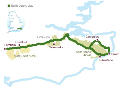
Productomschrijving: Kaart van de 208km, over de North Downs Way National Trail, tussen Farnham en Dover, met inbegrip van een optioneel bezoek aan Canterbury. Dit boekje is opgenomen in de Cicerone gids en toont het volledige parcours op OS 1: 25.000 kaarten. Een van de eenvoudigere nationale routes, dat comfortabel kan worden gelopen in 11-12 dagen.
Product decription: Map of the 130 mile (208km) North Downs Way National Trail, between Farnham and Dover, including an optional visit to Canterbury. This booklet is included with the Cicerone guidebook to the trail and shows the full route on OS 1:25,000 maps. One of the easier National Trails, it can be comfortably walked in 11-12 days.
Seasons:
The North Downs Way can be walked at any time of the year, but is seen at its best between April and October.
Centres:
Beginning in Farnham, the North Downs Way passes close to or through Guildford, Otford, Wrotham, Detling, Charing, Wye, Chilham, Canterbury and Patrixbourne and ends in Dover.
Difficulty:
Despite some reasonably short steep ascents and descents, the North Downs Way is one of the more gentle of National Trails and is suitable for first-time long-distance walkers.
Must See:
Passing through the Surrey and Kent Downs Areas of Outstanding Natural Beauty, the North Downs Way crosses Box Hill, visits Neolithic sites like the Coldrum Stones and Kits Coty House, passes below the remains of Thurnham Castle, visits Canterbury Cathedral and Dover Castle, and wanders across Shakespeare Cliff, one of the White Cliffs of Dover.
Locatie op kaart
Gekoppelde artikelen

Wandelgids North Downs Way Nat. trail - Cicerone • 9781852848613
standaard versieWandelgids North Downs Way Nat. trail - Cicerone Productomschrijving: Een wandelgids over de North Downs Way nationale Trail, een parcours van de 130 mijl (208km) tussen Farnham en Dover, met een optioneel bezoek aan de Canterbury. Naar aanleiding van de grotendeelse oude pelgrimsroute, door aangenaam platteland, dit is een van de éénvoudigere nationale routes waar de wandeling over 11 eta…

Wandelgids North Downs Way- 246 km - Trailblazer • 9781905864904
standaard versieThe 246 km long North Downs Way - Trailblazer Productomschrijving: The North Downs Way, is een lange afstand route van om en bij de 246 km. Een meerdaagse wandelroute in het zuiden van Engeland zeg maar. Het loopt van Farnham tot Dover, lags Guildford, Dorking, Merstham, Otford & Rochester, lags de Surrey Hills "Area of Outstanding Natural Beauty" (AONB) and Kent Downs AONB. De route besta…
Overzichtskaarten

Area's of Outstanding Natural Beauty - AONB's UK
Area's of Outstanding Natural Beauty - AONB's UK

Producten op de overzichtskaart
Klik op een product om naar de detailpagina te gaan.
- Wandelgids - Guide to the Cotswolds AONB - AA
- Wandelkaart 24 - Chilterns AONB - AA
- Fietskaart- en Mtb kaart - The Cotswolds - Goldeneye
- Wandelgids - Cotswold classic walks guidebook - Goldeneye
- Wandelgids - Exploring the Cotswolds - Goldeneye
- Wandelgids - Cotswold Classic Walks - Goldeneye
- Wandelkaart - Cotswolds- Malverns & Forest of Dean - Goldeneye
- Wandelgids - The Cotswold Way 30 classic routes - Cicerone
- Wandelgids - Kent walking guide - Cicerone
- Wandelgids - North Downs Way Nat. trail - Cicerone
- Wandelgids - Chilterns walking guide - Cicerone
- Wandelgids - Suffolk coast & Heaths walks - Cicerone
- Wandelgids - North Downs Way - Map Booklet - Cicerone
- Wandelgids - North Pennines AONB walking guide - Cicerone
- Wandelgids - Ridgeway National Trail - Cicerone
- Wandelgids - Forest of Bowland & Pendle - Cicerone
- Wandelgids - Hampshire's Test Way walking guide - Cicerone
- Wandelgids & Fietsgids - The Cotswold AONB - Cicerone
- Wandelgids - Walking on the Gower - Cicerone
- Wandelgids - North Wessex Downs - Cicerone Press
- Wandelgids - Walking on the North Wessex Downs - Cicerone
- Wandelgids - Silverdale & Arnside AONB - Cicerone
- Wandelgids - North Downs Way- 246 km - Trailblazer
- Wandelkaart OL2 - Yorkshire Dales- Southern & Western Areas - OSI
- Wandelkaart OL19 - Howgill Fells and Upper Eden Valley - OSI
- Wandelkaart OL21 - South Pennines - Yorkshire - OSI
- Wandelkaart OL31 - North Pennines- Teesdale & Weardale - OSI
- Wandelkaart OL40 - The Broads - OSI
- Wandelkaart OL41 - Forest of Bowland & Ribblesdale - OSI
- Wandelkaart OL45 - The Cotswolds AONB- Gloucestershire - OSI
- Wandelkaart 108 - Lower Tamer Valley & Plymouth- Cornwall- OSI
- Wandelkaart 115 - Exmouth & Sidmouth- Devon - OSI
- Wandelkaart 137 - Ashford- Kent downs AONB- England - OSI
- Wandelkaart 140 - Quantock Hills AONB- Somerset - OSI
- Wandelkaart 140 - Quantock Hills AONB & Bridgwater- Devon - OSI
- Wandelkaart 147 - Sevenoaks & Tonbridge- Kent - OSI
- Wandelkaart 164 - Gower AONB & Gwyr- South Wales - OSI
- Wandelkaart 164 - Gower AONB & Gwyr- Wales - OSI
- Wandelkaart 171 - Chiltern Hills West & Henley-on-Thames OSI
- Wandelkaart 171 - Chiltern Hills West AONB- Wycombe - OSI
- Wandelkaart 172 - Chiltern Hills East AONB- Wycombe - OSI
- Wandelkaart 181 - Chiltern Hills AONB North- England - OSI
- Wandelkaart 181 - Chiltern Hills North AONB- Wycombe - OSI
- Wandelkaart 190 - Malvern Hills & Bredon Hill - OSI
- Wandelkaart 190 - Malvern Hills AONB & Bredon Hill - OSI
- Wandelkaart 203 - Ludlow- Shropshire Hills AONB - OSI
- Wandelkaart 217 - Long Mynd & Wenlock Edge- Schropshire- OSI
- Wandelkaart 254 - Lleyn Peninsular East- North Wales - OSI
- Wandelkaart 261 - Boston- Lincolnshire AONB - OSI
- Wandelkaart 262 - Anglesey West- Wales AONB - OSI
- Wandelkaart 263 - Anglesey East AONB- Wales - OSI
- Wandelkaart 273 - Lincolnshire Wolds South AONB - OSI
- Wandelkaart 282 - Lincolnshire Wolds North AONB - OSI
- Wandelkaart 298 - Nidderdale AONB- Yorkshire - OSI
- Wandelkaart 298 - Nidderdale AONB North Yorkshire - OSI
- Wandelkaart 300 - Howardian Hills AONB - OSI
- Wandelkaart 300 - Howardian Hills AONB & Malton - OSI
- Wandelkaart - Mourne Mountains N. Ireland - Harvey maps
- Wandelkaart - Fietskaart Forest of Bowland - Harvey maps
- Wandelkaart XT40 - Anglesey Coastal Path N. Wales - Harvey Maps
- Wandelkaart XT40 - Pennine Way Noord - Harvey Maps
- Wandelkaart XT40 - Pennine Way Zuid - Harvey Maps
- Wandelgids Cotswold - Way Two-way trekking guide - Knife Edge
- Reisgids Oxford & the Cotswolds AONB - Edicola
- Reisgids Cotswolds England - Rough Guides
- Travelguide Oxford & The Cotswolds pocket guide - Lonely Planet
- Wandelgids - The Ridgeway National trail - Trailblazer
Artikelen uit dezelfde regio

Wandelkaart 137 Ashford Kent downs AONB England - OSI • 9780319470091
Wandelkaart Ashford - Kent downs AONB England - OSI Productbeschrijving: Kaart nummer 137 in de OS Explorer-serie dekt de volledige omgeving van Kent in de buurt van Ashford en de Kent Downs, een Area of Outstanding Natural Beauty AONB. De North Downs Way National Trail gaat langs de steden van Wye en Chilham, terwijl de Stour Valley Walk langs de Great Stour loopt. Andere hoogtepunten va…

Wandelkaart 189 Ashford & Romney Marsh - Kent - OSI • 9780319262870
Wandelkaart Ashford & Romney Marsh - Kent Productbeschrijving: Kaart nummer 189 in de OS Landranger kaarten reeks, is de ideale kaart voor de planning van dagexcursies en vakanties rond Kent aan de zuidkust van Engeland. Er zijn veel buitenactiviteiten te vinden in dit gebied, samen met de steden van Ashford, Romney March, Rye en Folkestone. De Noord-Downs Way loopt ook over de kaart heen.…

Wandelgids Ridgeway National Trail - Cicerone • 9781852848743
Wandelgids The Ridgeway National Trail 139 km - Cicerone Productomschrijving: Gids voor de beroemde Ridgeway National Trail, een route van 139 km door het zuiden van Engeland, van Avebury in Wiltshire naar Ivinghoe Beacon in Buckinghamshire. Deze gids, die vergezeld gaat van een 1:25K kaartboekje, beschrijft de route in beide richtingen en bevat informatie over historische plaatsen en faci…

Wandelgids 15 Short Walks in the Surrey Hills - Cicerone • 9781786311535
The Surrey Hills - 15 simple Short Walks - Cicerone Productomschrijving: Onze auteurs hebben 15 van de beste korte wandelingen rond Guildford, Dorking en het zuiden van Surrey uitgekozen. Elke wandeling is voorzien van goed leesbare Ordnance Survey-kaarten, een duidelijke routebeschrijving en veel foto's, plus informatie over mooie plekjes en smakelijke versnaperingen. Geen moeilijk terrei…

Wandelkaart 189 Ashford & Romney Marsh - England - OSI • 9780319475126
Wandelkaart Ashford & Romney Marsh - Rye Kent Productbeschrijving: Kaart nummer 189 in de OS Landranger kaarten reeks is de ideale kaart voor planning van daguitstapjes en vakanties rond Kent aan de zuidkust van Engeland. Er zijn veel mogelijkheden tot buitenactiviteiten in het gebied, samen met de steden van Ashford, Romney, March, Rye en Folkestone met de Noord-Downs Way lopen over de ka…