
Wandelgids & Fietsgids The Cotswold AONB - Cicerone
De Cotswolds zijn de thuisbasis van de mooie honing-hued stenen
Korte omschrijving
Wandelgids & Fietsgids - The Cotswold AONB - Cicerone Productomschrijving: De Cotswolds is de thuisbasis van mooie honing-hued stenen dorpen in een glooiende landschap. De dramatische 100-mi...

Specificaties
- Uitgever: CICERONE Press
- ISBN-13: 9781852847067
- HOOFDCATEGORIEËN: Fietsgids, Wandelgids
- Activiteiten: Fietsen / VTT / MTB, Wandelen, Hiking & Trekking
- Regio: Gloucestershire, Egland, Oxfordshire West England, Somerset South West England, Warwickshire, West Midlands, Wiltshire, West England
- Land: England
- AONB - Area of Outstanding Beauty: The Cotswolds AONB
- Blz.: 208
- Afmeting: 12x17
- Editie: 1
- Taal: Engels
Volledige omschrijving
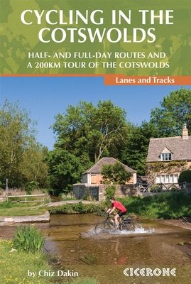
Wandelgids & Fietsgids - The Cotswold AONB - Cicerone
Productomschrijving: De Cotswolds is de thuisbasis van mooie honing-hued stenen dorpen in een glooiende landschap. De dramatische 100-mijl lange kalkstenen helling biedt een adembenemend uitzicht, terwijl het netwerk van rustige wegen, fietsvriendelijke kanaalwegen, sporen en ruiterpaden perfect is voor verkenning op een fiets. De Cotwold is ook geklasseerd als AONB gebied, Area of Oustanding Natural Beauty. Een must voor de fietser en de wandelaar, gezien deze uitermate mooie gebieden op een kleine lijst kunnen worden genoteerd.
Product description: Guidebook of 21 half and full-day cycle routes, and one 4-day 200km tour of the Cotswolds. All the routes described are suitable for hybrid or mountain bikes, and most routes have an on-road alternative. The Cotswolds boasts cycle-friendly lanes, rolling countryside, canal paths and bridleways perfect for exploration by bike.
Seasons:
Routes are best ridden in dry conditions (usually mid-spring to mid-autumn); winter/prolonged wet conditions can get make them very boggy/flooded
Centres:
Stratford-upon-Avon, Shipston-on-Stour, Burford-on-the-Water, Winchcombe, Cirencester, Fairford, Stow-on-the-Wold, Shipton-under-Wychwood, Cheltenham, Stroud, Malmesbury, Bradford-onAvon/Bath.
Difficulty:
Routes are graded moderate to challenging, although very short off-road sections may be challenging at all grades for those new to off-road riding; mountain bikes are recommended, but alternatives are given for road bikes wherever possible; basic level of fitness required for all routes, more for longer/multiday routes.
Must See:
Old-world charm, local honey-coloured limestone, thatched roofs and half-timbered buildings in impossibly pretty villages; wide variety of history from neolithic through Roman times to Middle Ages, long barrows, wool towns and ancient markets; Two Tunnels cycle route and a 4-day tour of whole area.
Route 1 Shipston-on-Stour Loop via Brailes Hill
Route 2 Shipston-on-Stour Loop via Halford
Route 3 Shipton-under-Wychwood Loop via Wychwood
Route 4 Bourton-on-the-Water Loop via the Slaughters
Route 5 Alderton via Broadway
Route 6 Bradford-on-Avon via Bath Two Tunnels
Route 7 Bourton-on-the-Water Loop via Great Barrington
Route 8 Kemble via Cotswold Water Park
Route 9 Kingham Loop via Bruern Abbey
Route 10 Batheaston Sting
Route 11 Stratford Greenway Loop via Mickleton
Route 12 Cirencester Loop via Ampney Crucis
Route 13 Filkins Loop via Bibury
Route 14 Fairford Loop via Bibury
Route 15 Frampton Cotterell Loop via Wickwar
Route 16 Stonehouse Loop via Slimbridge
Route 17 Stow Loop via Blockley
Route 18 Burford Loop via Northleach
Route 19 Stroud Loop via Chavenage House
Route 20 Cheltenham Loop via Cleeve Hill
Route 21 Malmesbury Loop via Tetbury
Route 22 Around the Cotswolds
Day 1 Stroud to Winchcombe
Day 2 Winchcombe to Stow-on-the-Wold
Day 3 Stow-on-the-Wold to Cirencester
Day 4 Cirencester to Stroud
Locatie op kaart
Overzichtskaarten

Area's of Outstanding Natural Beauty - AONB's UK
Area's of Outstanding Natural Beauty - AONB's UK

Producten op de overzichtskaart
Klik op een product om naar de detailpagina te gaan.
- Wandelgids - Guide to the Cotswolds AONB - AA
- Wandelkaart 24 - Chilterns AONB - AA
- Fietskaart- en Mtb kaart - The Cotswolds - Goldeneye
- Wandelgids - Cotswold classic walks guidebook - Goldeneye
- Wandelgids - Exploring the Cotswolds - Goldeneye
- Wandelgids - Cotswold Classic Walks - Goldeneye
- Wandelkaart - Cotswolds- Malverns & Forest of Dean - Goldeneye
- Wandelgids - The Cotswold Way 30 classic routes - Cicerone
- Wandelgids - Kent walking guide - Cicerone
- Wandelgids - North Downs Way Nat. trail - Cicerone
- Wandelgids - Chilterns walking guide - Cicerone
- Wandelgids - Suffolk coast & Heaths walks - Cicerone
- Wandelgids - North Downs Way - Map Booklet - Cicerone
- Wandelgids - North Pennines AONB walking guide - Cicerone
- Wandelgids - Ridgeway National Trail - Cicerone
- Wandelgids - Forest of Bowland & Pendle - Cicerone
- Wandelgids - Hampshire's Test Way walking guide - Cicerone
- Wandelgids & Fietsgids - The Cotswold AONB - Cicerone
- Wandelgids - Walking on the Gower - Cicerone
- Wandelgids - North Wessex Downs - Cicerone Press
- Wandelgids - Walking on the North Wessex Downs - Cicerone
- Wandelgids - Silverdale & Arnside AONB - Cicerone
- Wandelgids - North Downs Way- 246 km - Trailblazer
- Wandelkaart OL2 - Yorkshire Dales- Southern & Western Areas - OSI
- Wandelkaart OL19 - Howgill Fells and Upper Eden Valley - OSI
- Wandelkaart OL21 - South Pennines - Yorkshire - OSI
- Wandelkaart OL31 - North Pennines- Teesdale & Weardale - OSI
- Wandelkaart OL40 - The Broads - OSI
- Wandelkaart OL41 - Forest of Bowland & Ribblesdale - OSI
- Wandelkaart OL45 - The Cotswolds AONB- Gloucestershire - OSI
- Wandelkaart 108 - Lower Tamer Valley & Plymouth- Cornwall- OSI
- Wandelkaart 115 - Exmouth & Sidmouth- Devon - OSI
- Wandelkaart 137 - Ashford- Kent downs AONB- England - OSI
- Wandelkaart 140 - Quantock Hills AONB- Somerset - OSI
- Wandelkaart 140 - Quantock Hills AONB & Bridgwater- Devon - OSI
- Wandelkaart 147 - Sevenoaks & Tonbridge- Kent - OSI
- Wandelkaart 164 - Gower AONB & Gwyr- South Wales - OSI
- Wandelkaart 164 - Gower AONB & Gwyr- Wales - OSI
- Wandelkaart 171 - Chiltern Hills West & Henley-on-Thames OSI
- Wandelkaart 171 - Chiltern Hills West AONB- Wycombe - OSI
- Wandelkaart 172 - Chiltern Hills East AONB- Wycombe - OSI
- Wandelkaart 181 - Chiltern Hills AONB North- England - OSI
- Wandelkaart 181 - Chiltern Hills North AONB- Wycombe - OSI
- Wandelkaart 190 - Malvern Hills & Bredon Hill - OSI
- Wandelkaart 190 - Malvern Hills AONB & Bredon Hill - OSI
- Wandelkaart 203 - Ludlow- Shropshire Hills AONB - OSI
- Wandelkaart 217 - Long Mynd & Wenlock Edge- Schropshire- OSI
- Wandelkaart 254 - Lleyn Peninsular East- North Wales - OSI
- Wandelkaart 261 - Boston- Lincolnshire AONB - OSI
- Wandelkaart 262 - Anglesey West- Wales AONB - OSI
- Wandelkaart 263 - Anglesey East AONB- Wales - OSI
- Wandelkaart 273 - Lincolnshire Wolds South AONB - OSI
- Wandelkaart 282 - Lincolnshire Wolds North AONB - OSI
- Wandelkaart 298 - Nidderdale AONB- Yorkshire - OSI
- Wandelkaart 298 - Nidderdale AONB North Yorkshire - OSI
- Wandelkaart 300 - Howardian Hills AONB - OSI
- Wandelkaart 300 - Howardian Hills AONB & Malton - OSI
- Wandelkaart - Mourne Mountains N. Ireland - Harvey maps
- Wandelkaart - Fietskaart Forest of Bowland - Harvey maps
- Wandelkaart XT40 - Anglesey Coastal Path N. Wales - Harvey Maps
- Wandelkaart XT40 - Pennine Way Noord - Harvey Maps
- Wandelkaart XT40 - Pennine Way Zuid - Harvey Maps
- Wandelgids Cotswold - Way Two-way trekking guide - Knife Edge
- Reisgids Oxford & the Cotswolds AONB - Edicola
- Reisgids Cotswolds England - Rough Guides
- Travelguide Oxford & The Cotswolds pocket guide - Lonely Planet
- Wandelgids - The Ridgeway National trail - Trailblazer
Artikelen uit dezelfde regio

Wandelkaart 167 Thornbury Dursley & Yate England- OSI • 9780319470398
Wandelkaart Thornbury- Dursley & Yate - Gloucestershire Omvat ook: Berkeley & Wotton-under-Edge. Productbeschrijving: Kaart nummer 167 in de OS Explorer-reeks omvat het gebied ten noorden van Bristol langs de rivier de Severn tussen Engeland en Wales. Hoogtepunten van het gebied zijn ondermeer: Forest of Avon, de Cotswolds en de Wye Valley, met inbegrip van de Cotswold Way Offa's Dyke …
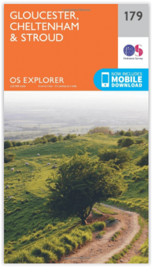
Wandelkaart 179 Gloucester Cheltenham & Stroud - OSI • 9780319243725
Wandelkaart Gloucester- Cheltenham & Stroud - Gloucestershire Productbeschrijving: Gloucester & Cheltenham 179 / Gloucester, Cheltenham & Stroud, Gloucestershire, England - Kaart nummer 179 in de OS Explorer reeks heeft betrekking op de omgeving van Gloucester, Cheltenham, Stroud. Hoogtepunten van het gebied zijn onder meer: The Cotswolds AONB gebied van uitzonderlijke natuurlijke scho…

Wandelgids Cotswolds AONB 50 walks guide - AA Publishing • 9780749583224
Cotswolds AONB - 50 walks guide - AA Publishing Productomschrijving: Wandelen is een van de favoriete vrijetijdsbestedingen van Groot-Brittannië. AA 50 Walks in the Cotswolds bevat een verscheidenheid aan uitgestippelde wandelingen van 3 tot 12 km, geschikt voor alle niveaus. Het boek bevat alle praktische details die u nodig hebt, vergezeld van boeiende achtergrondinformatie over de gesch…

Wandelgids Walking in the Forest of Dean - Cicerone • 9781852846893
Wandelgids - Walking in the Forest of Dean - Cicerone Productomschrijving: Een gids over 25 wandelingen in de Forest of Dean, met alle informatie die nodig is om te genieten van een scala aan wandelingen in de dallen en de open ruimtes van dit oude gebied. Van korte 4-mijl lange wandelingen tot volle dagsecties van interlokale paden zoals de Offa's Dyke Path en Gloucestershire Way, is deze…

Wandelgids Guide to the Cotswolds AONB - AA • 9780749579418
Wandelgids - Guide to the Cotswolds AONB - AA Productomschrijving: The Cotswolds zijn een regio van uitmuntend natuurlijk schoon, of in andere woorden, "Area of Outstanding Natural Beauty". Zo noemen de britten hun meest geliefde regio's. WIj spreken oven nationale parken or regionale parken, terwijl de britten er eveneens over beschikken, maar de AONB's gaan voor op de rest. Talloze route…