
Wandelgids Silverdale & Arnside AONB - Cicerone
21 dagwandelingen langs ruige kustpaden & bosroutes


Korte omschrijving
Wandelgids - Silverdale & Arnside AONB - Cicerone Omvat: Leighton Moss, Dallam Park, Arnside Knott, Hutton Roof en Morecambe Bay Productomschrijving: Deze handige gids van 21 makkelijke...

Specificaties
- Uitgever: CICERONE Press
- ISBN-13: 9781852846282
- HOOFDCATEGORIEËN: Wandelgids
- Activiteiten: Wandelen, Hiking & Trekking
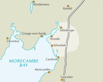
- Regio: Lanacshire, England, North West England
- Land: England
- AONB - Area of Outstanding Beauty: Arnside AONB, Silverdale AONB
- Blz.: 160
- Afmeting: 12x17
- Editie: 2
- Taal: Engels
Volledige omschrijving
Wandelgids - Silverdale & Arnside AONB - Cicerone
Omvat: Leighton Moss, Dallam Park, Arnside Knott, Hutton Roof en Morecambe Bay
Productomschrijving: Deze handige gids van 21 makkelijke dagwandelingen is gegarandeerd om u te helpen bij het verkennen van fantastische landschappen in de vorm van ruige kustpaden en betoverende bosroutes. Er zijn routes van verschillende terreinen door Leighton Moss (RSPB centrum), Dallam Park, Arnside Knott, Hutton Roof en Morecambe Bay die geschikt zijn voor het hele gezin.
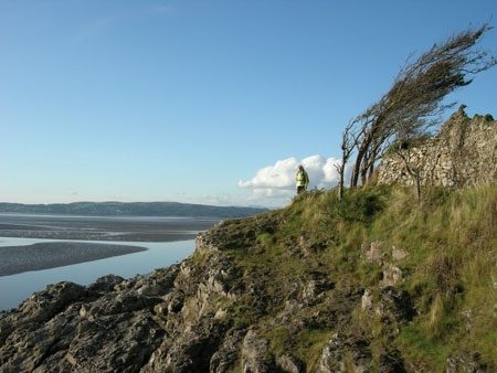
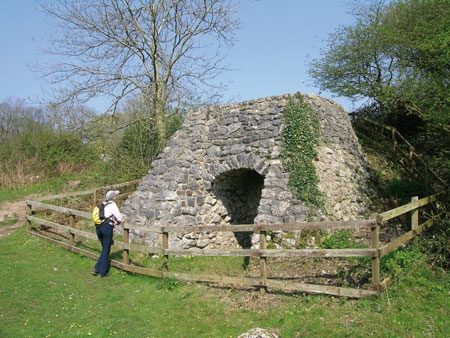
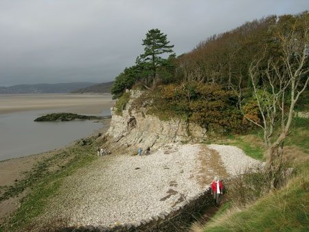
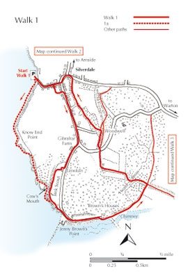
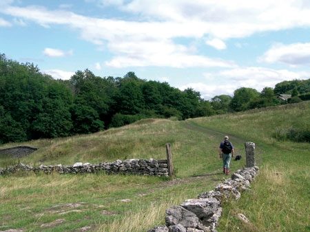
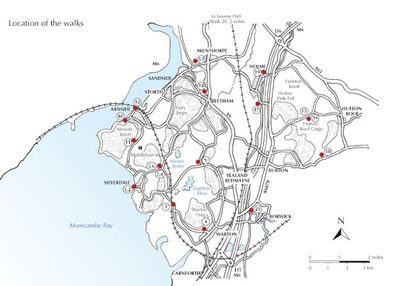
Detail: De routes in deze gids beschreven, liggen grotendeels binnen de Arnside en Silverdale ruimte die bijna het hele land ten westen van de A6 tussen Warton en Tilburg omvat. De wandelingen bieden alle attracties van de kust, bossen, weiden en heuvel waarmee het gebied zo speciaal maakt, en zijn bekwaam om bezoekers een reële appreciatie van de AONB (Areas of Outstanding Natural Beauty) te ontwikkelen. De meeste van de dagwandelingen zijn op goed aangeduide, goed vertrappelde paden geschikt voor het hele gezin.
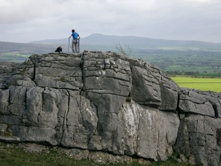
Het terrein varieert van rotsachtige en ruige kusten tot gladde kalksteen wegdekken en bosrijke paden. Scrambling langs de rotsachtige kust is moeilijker geworden sinds de ondergang van het zoute moeras en sinds er zorg moet worden genomen om te luisteren naar de inkomende stroom.
Product description: The 21 easy day walks in this book will help you explore the Silverdale and Arnside Area of Outstanding Natural Beauty, with its rugged coastal paths and enchanting woodland trails. There are routes through Leighton Moss (RSPB centre), Dallam Park, Arnside Knott, Hutton Roof and Morecambe Bay that are suitable for all abilities and every season.
Seasons:
Can be enjoyed throughout the year; spring with its abundant flowers and the colourful displays of autumn are especially rewarding; summer is the busiest time; in winter vast flocks of birds can be seen in Morecambe Bay; the woods provide sheltered walking in strong wind.
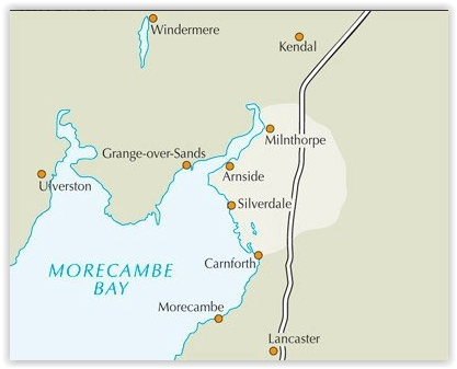
Centres:
The villages of Silverdale, Arnside and Warton have small shops; more facilities are available at Milnthorpe and Carnforth; accommodation in the area is plentiful, including hotels, guest houses, B&B and campsites.
Difficulty:
Most walks on well signed, well-trodden paths, sometimes crossing bare limestone or rough and rooty underfoot; scrambling along the rocky shore requires care to heed the incoming tide, although there are safe high tide options; walks are between 2 and 8 miles but can be easily linked into longer walks.
Must See:
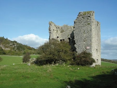
The best coastal scenery and the highest concentration of woodland paths in NW England; views over Morecambe Bay and the Lakeland fells; densely wooded limestone hills rich in flora and fauna; Warton Crag, Arnside Knott, Farleton Knott, Holme Park Fell and Hutton Roof Crags; Leighton Moss RSPB reserve and several Nature Reserves.
Locatie op kaart
Overzichtskaarten

Area's of Outstanding Natural Beauty - AONB's UK
Area's of Outstanding Natural Beauty - AONB's UK

Producten op de overzichtskaart
Klik op een product om naar de detailpagina te gaan.
- Wandelgids - Guide to the Cotswolds AONB - AA
- Wandelkaart 24 - Chilterns AONB - AA
- Fietskaart- en Mtb kaart - The Cotswolds - Goldeneye
- Wandelgids - Cotswold classic walks guidebook - Goldeneye
- Wandelgids - Exploring the Cotswolds - Goldeneye
- Wandelgids - Cotswold Classic Walks - Goldeneye
- Wandelkaart - Cotswolds- Malverns & Forest of Dean - Goldeneye
- Wandelgids - The Cotswold Way 30 classic routes - Cicerone
- Wandelgids - Kent walking guide - Cicerone
- Wandelgids - North Downs Way Nat. trail - Cicerone
- Wandelgids - Chilterns walking guide - Cicerone
- Wandelgids - Suffolk coast & Heaths walks - Cicerone
- Wandelgids - North Downs Way - Map Booklet - Cicerone
- Wandelgids - North Pennines AONB walking guide - Cicerone
- Wandelgids - Ridgeway National Trail - Cicerone
- Wandelgids - Forest of Bowland & Pendle - Cicerone
- Wandelgids - Hampshire's Test Way walking guide - Cicerone
- Wandelgids & Fietsgids - The Cotswold AONB - Cicerone
- Wandelgids - Walking on the Gower - Cicerone
- Wandelgids - North Wessex Downs - Cicerone Press
- Wandelgids - Walking on the North Wessex Downs - Cicerone
- Wandelgids - Silverdale & Arnside AONB - Cicerone
- Wandelgids - North Downs Way- 246 km - Trailblazer
- Wandelkaart OL2 - Yorkshire Dales- Southern & Western Areas - OSI
- Wandelkaart OL19 - Howgill Fells and Upper Eden Valley - OSI
- Wandelkaart OL21 - South Pennines - Yorkshire - OSI
- Wandelkaart OL31 - North Pennines- Teesdale & Weardale - OSI
- Wandelkaart OL40 - The Broads - OSI
- Wandelkaart OL41 - Forest of Bowland & Ribblesdale - OSI
- Wandelkaart OL45 - The Cotswolds AONB- Gloucestershire - OSI
- Wandelkaart 108 - Lower Tamer Valley & Plymouth- Cornwall- OSI
- Wandelkaart 115 - Exmouth & Sidmouth- Devon - OSI
- Wandelkaart 137 - Ashford- Kent downs AONB- England - OSI
- Wandelkaart 140 - Quantock Hills AONB- Somerset - OSI
- Wandelkaart 140 - Quantock Hills AONB & Bridgwater- Devon - OSI
- Wandelkaart 147 - Sevenoaks & Tonbridge- Kent - OSI
- Wandelkaart 164 - Gower AONB & Gwyr- South Wales - OSI
- Wandelkaart 164 - Gower AONB & Gwyr- Wales - OSI
- Wandelkaart 171 - Chiltern Hills West & Henley-on-Thames OSI
- Wandelkaart 171 - Chiltern Hills West AONB- Wycombe - OSI
- Wandelkaart 172 - Chiltern Hills East AONB- Wycombe - OSI
- Wandelkaart 181 - Chiltern Hills AONB North- England - OSI
- Wandelkaart 181 - Chiltern Hills North AONB- Wycombe - OSI
- Wandelkaart 190 - Malvern Hills & Bredon Hill - OSI
- Wandelkaart 190 - Malvern Hills AONB & Bredon Hill - OSI
- Wandelkaart 203 - Ludlow- Shropshire Hills AONB - OSI
- Wandelkaart 217 - Long Mynd & Wenlock Edge- Schropshire- OSI
- Wandelkaart 254 - Lleyn Peninsular East- North Wales - OSI
- Wandelkaart 261 - Boston- Lincolnshire AONB - OSI
- Wandelkaart 262 - Anglesey West- Wales AONB - OSI
- Wandelkaart 263 - Anglesey East AONB- Wales - OSI
- Wandelkaart 273 - Lincolnshire Wolds South AONB - OSI
- Wandelkaart 282 - Lincolnshire Wolds North AONB - OSI
- Wandelkaart 298 - Nidderdale AONB- Yorkshire - OSI
- Wandelkaart 298 - Nidderdale AONB North Yorkshire - OSI
- Wandelkaart 300 - Howardian Hills AONB - OSI
- Wandelkaart 300 - Howardian Hills AONB & Malton - OSI
- Wandelkaart - Mourne Mountains N. Ireland - Harvey maps
- Wandelkaart - Fietskaart Forest of Bowland - Harvey maps
- Wandelkaart XT40 - Anglesey Coastal Path N. Wales - Harvey Maps
- Wandelkaart XT40 - Pennine Way Noord - Harvey Maps
- Wandelkaart XT40 - Pennine Way Zuid - Harvey Maps
- Wandelgids Cotswold - Way Two-way trekking guide - Knife Edge
- Reisgids Oxford & the Cotswolds AONB - Edicola
- Reisgids Cotswolds England - Rough Guides
- Travelguide Oxford & The Cotswolds pocket guide - Lonely Planet
- Wandelgids - The Ridgeway National trail - Trailblazer
Artikelen uit dezelfde regio

Wandelkaart Coast to Coast (west) St Bees to Keld - Harvey maps • 978185137618
Wandelkaart Coast to Coast (west) St Bees to Keld - Harvey maps Productomschrijving: Toont de gehele westelijke helft van de route op één deel van de kaart. Heeft betrekking op het gedeelte van St Bees naar Keld. Omvat alle alternatieve routes. Gedetailleerde kaart met aanvullende informatie en handige telefoonnummers, schaal van 1: 40.000. Nieuwe generatie HARVEY Superwalker, XT25 wat…

Wandelgids West Pennine Moors walking guide - Cicerone • 9781852845803
Wandelgids - West Pennine Moors walking guide - Cicerone Productomschrijving: Wandelen in de West Pennine Moors, beschrijft 30 wandelingen op het platteland rondom Blackburn, Darwen, Chorley en Bolton, de thuis van enkele van de meest inspirerende en opwindende wandelgebieden. De wandelingen variëren van korte, gemakkelijke scrambles tot meer uitdagende wandelingen die betrekking hebben op…

Wandelgids The Ribble way - Cicerone • 9781786310910
Wandelgids The Ribble way - Cicerone Productomschrijving: Deze gids beschrijft de Ribble Way, een route van 116 km die de Ribble vallei volgt, van de monding van de rivier bij Preston tot de bron van de rivier bij Cam Fell in de Yorkshire Dales. Het boek bevat een volledige routebeschrijving opgedeeld in 7 overzichtelijke etappes, met suggesties voor dagwandelaars. Engelse omschr…
Wandelgids Northern England Backpacker's - Cicerone • 9781852843205
Wandelgids - Northern England Backpacker's - Cicerone Productomschrijving: Een gids van 25 wandelroutes voor grote backpacker overal in Noord-Engeland van de Yorkshire Dales en het Forest of Bowland, het Lake District, de Pennines, en tot de Cheviots op de Schotse grens. Taaie routes te doen in een dag, maar wel goede tweedaagse uitstapjes op externe plaatsen. Een full-color gids voor 25 g…
Wandelgids Forest of Bowland walking guide - Cicerone • 9781852842512
Wandelgids - Forest of Bowland walking guide - Cicerone Productomschrijving: Gids voor wandelingen in het Forest of Bowland, Lancashire, Noord-Engeland, een Area of Outstanding Natural Beauty. 30 routes in het hele Forest met inbegrip van de zachte uitlopers in het zuiden en noorden, op de top van de moerassen en in de valleien. De Forest of Bowland, is een wilde en dunbevolkte regio van z…