
Wandelgids Suffolk coast & Heaths walks - Cicerone
Een omgeving van uitzonderlijk natuurlijk schoon


Korte omschrijving
Wandelgids - Suffolk coast & Heaths walks - Cicerone Productomschrijving: 3 langeafstand wandelingen door deze prachtige AONB regio. Een omgeving van uitzonderlijk natuurlijk schoon, die bek...

Specificaties
- Uitgever: CICERONE Press
- ISBN-13: 9781852848705
- HOOFDCATEGORIEËN: Wandelgids
- Activiteiten: Wandelen, Hiking & Trekking
- Regio: Suffolk East Anglia
- Land: England
- AONB - Area of Outstanding Beauty: Suffolk Coast and Heaths AONB
- Blz.: 176
- Afmeting: 12x17
- Editie: 2
- Taal: Engels
Volledige omschrijving
Wandelgids - Suffolk coast & Heaths walks - Cicerone
Productomschrijving: 3 langeafstand wandelingen door deze prachtige AONB regio. Een omgeving van uitzonderlijk natuurlijk schoon, die bekend staat bij vele Engelsen als een uitstap- of weekend wandelplaats. De Cicerone gidsen zijn uniek in hun genre en bieden een prachtig overzicht over een van Engelands grootste aantrekkingspolen, de AONB regio's
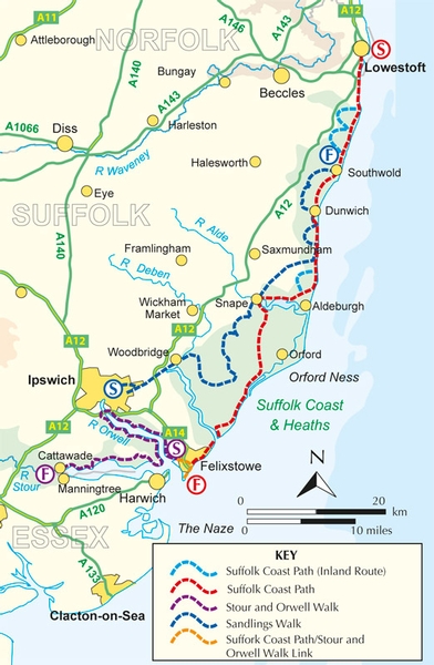
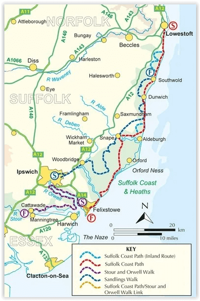
Product description: The three long-distance walks described in this book - the Suffolk Coast Path, the Stour and Orwell Walk and the Sandlings Walk - link together to provide a comprehensive and varied circuit of the entire Suffolk Heritage Coast. The Suffolk Coast Path stretches along the coast between Lowestoft and Landguard Fort, close to Felixstowe in the south, a total distance of 60 miles (97km) depending on whether beach walking or inland options are followed.
Seasons:
All the routes can be walked at any time of year; summer is the busiest time and accommodation may be hard to find during the Aldeburgh Festival in June; spring and autumn are best for watching birds; winter has its own charm when you may find that you have the place to yourself.
Centres:
Lowestoft, Southwold, Felixstowe and Ipswich.
Difficulty:
All of these coast and heath walks are easy for those of moderate fitness; no special ability or equipment is necessary and the only challenge comes from attempting to complete the long-distance routes in succession as a multi-day itinerary.
Must See:
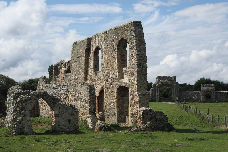
Suffolk Coast & Heaths AONB; once-great sea ports like Southwold, Dunwich and Aldeburgh; a landscape characterised by estuaries, marshes, dunes, sand and shingle beaches; unique scenery and wildlife.
Locatie op kaart
Overzichtskaarten

Area's of Outstanding Natural Beauty - AONB's UK
Area's of Outstanding Natural Beauty - AONB's UK

Producten op de overzichtskaart
Klik op een product om naar de detailpagina te gaan.
- Wandelgids - Guide to the Cotswolds AONB - AA
- Wandelkaart 24 - Chilterns AONB - AA
- Fietskaart- en Mtb kaart - The Cotswolds - Goldeneye
- Wandelgids - Cotswold classic walks guidebook - Goldeneye
- Wandelgids - Exploring the Cotswolds - Goldeneye
- Wandelgids - Cotswold Classic Walks - Goldeneye
- Wandelkaart - Cotswolds- Malverns & Forest of Dean - Goldeneye
- Wandelgids - The Cotswold Way 30 classic routes - Cicerone
- Wandelgids - Kent walking guide - Cicerone
- Wandelgids - North Downs Way Nat. trail - Cicerone
- Wandelgids - Chilterns walking guide - Cicerone
- Wandelgids - Suffolk coast & Heaths walks - Cicerone
- Wandelgids - North Downs Way - Map Booklet - Cicerone
- Wandelgids - North Pennines AONB walking guide - Cicerone
- Wandelgids - Ridgeway National Trail - Cicerone
- Wandelgids - Forest of Bowland & Pendle - Cicerone
- Wandelgids - Hampshire's Test Way walking guide - Cicerone
- Wandelgids & Fietsgids - The Cotswold AONB - Cicerone
- Wandelgids - Walking on the Gower - Cicerone
- Wandelgids - North Wessex Downs - Cicerone Press
- Wandelgids - Walking on the North Wessex Downs - Cicerone
- Wandelgids - Silverdale & Arnside AONB - Cicerone
- Wandelgids - North Downs Way- 246 km - Trailblazer
- Wandelkaart OL2 - Yorkshire Dales- Southern & Western Areas - OSI
- Wandelkaart OL19 - Howgill Fells and Upper Eden Valley - OSI
- Wandelkaart OL21 - South Pennines - Yorkshire - OSI
- Wandelkaart OL31 - North Pennines- Teesdale & Weardale - OSI
- Wandelkaart OL40 - The Broads - OSI
- Wandelkaart OL41 - Forest of Bowland & Ribblesdale - OSI
- Wandelkaart OL45 - The Cotswolds AONB- Gloucestershire - OSI
- Wandelkaart 108 - Lower Tamer Valley & Plymouth- Cornwall- OSI
- Wandelkaart 115 - Exmouth & Sidmouth- Devon - OSI
- Wandelkaart 137 - Ashford- Kent downs AONB- England - OSI
- Wandelkaart 140 - Quantock Hills AONB- Somerset - OSI
- Wandelkaart 140 - Quantock Hills AONB & Bridgwater- Devon - OSI
- Wandelkaart 147 - Sevenoaks & Tonbridge- Kent - OSI
- Wandelkaart 164 - Gower AONB & Gwyr- South Wales - OSI
- Wandelkaart 164 - Gower AONB & Gwyr- Wales - OSI
- Wandelkaart 171 - Chiltern Hills West & Henley-on-Thames OSI
- Wandelkaart 171 - Chiltern Hills West AONB- Wycombe - OSI
- Wandelkaart 172 - Chiltern Hills East AONB- Wycombe - OSI
- Wandelkaart 181 - Chiltern Hills AONB North- England - OSI
- Wandelkaart 181 - Chiltern Hills North AONB- Wycombe - OSI
- Wandelkaart 190 - Malvern Hills & Bredon Hill - OSI
- Wandelkaart 190 - Malvern Hills AONB & Bredon Hill - OSI
- Wandelkaart 203 - Ludlow- Shropshire Hills AONB - OSI
- Wandelkaart 217 - Long Mynd & Wenlock Edge- Schropshire- OSI
- Wandelkaart 254 - Lleyn Peninsular East- North Wales - OSI
- Wandelkaart 261 - Boston- Lincolnshire AONB - OSI
- Wandelkaart 262 - Anglesey West- Wales AONB - OSI
- Wandelkaart 263 - Anglesey East AONB- Wales - OSI
- Wandelkaart 273 - Lincolnshire Wolds South AONB - OSI
- Wandelkaart 282 - Lincolnshire Wolds North AONB - OSI
- Wandelkaart 298 - Nidderdale AONB- Yorkshire - OSI
- Wandelkaart 298 - Nidderdale AONB North Yorkshire - OSI
- Wandelkaart 300 - Howardian Hills AONB - OSI
- Wandelkaart 300 - Howardian Hills AONB & Malton - OSI
- Wandelkaart - Mourne Mountains N. Ireland - Harvey maps
- Wandelkaart - Fietskaart Forest of Bowland - Harvey maps
- Wandelkaart XT40 - Anglesey Coastal Path N. Wales - Harvey Maps
- Wandelkaart XT40 - Pennine Way Noord - Harvey Maps
- Wandelkaart XT40 - Pennine Way Zuid - Harvey Maps
- Wandelgids Cotswold - Way Two-way trekking guide - Knife Edge
- Reisgids Oxford & the Cotswolds AONB - Edicola
- Reisgids Cotswolds England - Rough Guides
- Travelguide Oxford & The Cotswolds pocket guide - Lonely Planet
- Wandelgids - The Ridgeway National trail - Trailblazer
Artikelen uit dezelfde regio

Wandelkaart 134 Norwich- The Broads NP & Great Yarmouth - OSI • 9780319475515
Norwich- The Broads NP & Great Yarmouth - OSI Productomschrijving: Het Broads Nationaal Park is een groot waterrijk gebied en omvat een netwerk van rivieren binnen de graafschappen Norfolk en Suffolk. Er zijn veel natuurreservaten en mogelijkheden om te wandelen, fietsen en vissen. Veel van het prachtige landschap van de Broads komt het best tot zijn recht per boot en bij verschillende lok…

Wandelkaart OL40 The Broads - OSI • 9780319475485
Wandelkaart The Broads National Park - OSI Productomschrijving: Kaart OL40 in de OS Explorer serie bestrijkt The Broads, een lid van de familie van nationale parken. De rivieren zijn de Bure, Ant, Thurne, Yare, Chet en Waveney. De kaart toont ook de kusten van Norfolk en Suffolk en de badplaatsen Great Yarmouth en Lowestoft. Een ander hoogtepunt van het gebied is de stad Norwich. Inclu…

Wandelkaart 211 Bury St Edmunds & Stowmarket - OSI • 9780319470831
Wandelkaart Bury St Edmunds & Stowmarket - Suffolk Omvat ook: Debenham & Elmswell. Productbeschrijving: Deze twee-zijdige kaart toont Bury St Edmunds tot Debenham, met inbegrip van Stowmarket. Er zijn een aantal recreatieve paden met inbegrip van St Edmund's way die hier voorbijlopen, de Adelborst Railway trail en deel van de Mid Suffolk trail. Er zijn ook vele kleine steden en dorpen …

Wandelkaart 210 Newmarket- Haverhill & Barrow - OSI • 9780319244036
Wandelkaart Newmarket- Haverhill & Barrow - Suffolk Omvat ook: Barrow, Clare & Kedington Productomschrijving: Kaart nummer 210 in de OS Explorer kaarten reeks is ideaal voor het ontdekken van het gebied rond het Oosten van het graafschap Cambridgeshire en ten westen van Suffolk, rond de stad van Newmarket raceway. U kunt er de Stour Valley bewandelen naast de rivier de Stour, of u kunt…

Wandelkaart 230 Diss- Harleston & East Harling - OSI • 9780319244234
Wandelkaart Diss- Harleston- East Harling - Suffolk England Productbeschrijving: - East Harling & Stanton. 230 / Diss, Harleston, East Harling, Suffolk, England - Na de rivier Waveney is deze OS Explorer kaart 230 een ' double-sided map, die East Harling, Diss en Harleston omvat. Hoogtepunten van het gebied vormen deel van de Norfolk kust pad National Trail, Footpath, Hereward way, Ped…