
Wandelkaart OL22 New Forest- Southampton & Ringwood - OSI
New Forest Nationaal Park in West Engeland

Korte omschrijving
Wandelkaart New Forest national park - Southampton - OSI Productomschrijving: Kaart nummer OL22 in de OS Explorer kaartenserie is de perfecte kaart voor vakantiegangers en dagjesmensen om te...

Specificaties
- Uitgever: Ordnance Survey
- ISBN-13: 9780319475782
- HOOFDCATEGORIEËN: Wandelkaart
- Activiteiten: Wandelen, Hiking & Trekking
- Regio: South & South East England
- Land: England
- Waterafstotende kaart: Ordnance Survey ACTIVE Explorer Weatherproof Maps
- Nationale parken: New Forest National Park, England
- AONB - Area of Outstanding Beauty: Cranborne Chase AONB, Isle of Wight AONB, Newport, Verenigd Koninkrijk, West Wiltshire Downs AONB
- Schaal: 1:25000
- Afmeting: 13x24
- Taal: Engels
- Reeks: Explorer ACTIVE Series OSI
Volledige omschrijving
Wandelkaart New Forest national park - Southampton - OSI
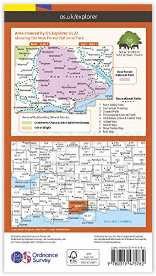
Productomschrijving: Kaart nummer OL22 in de OS Explorer kaartenserie is de perfecte kaart voor vakantiegangers en dagjesmensen om te gebruiken bij een bezoek aan het New Forest Nationaal Park in West Engeland. Het nationale park is beroemd om zijn uitstekende wandelingen en ritten en is de thuisbasis van New Forest pony's en heidelandschap.
Engelse omschrijving: Map sheet number OL22 in the OS Explorer map series is the perfect map for holiday makers and day trippers to use when visiting the New Forest. The national park is famous for its excellent walks and rides and is home to New Forest ponies and heath land scenery.
Recreational Paths:
- Avon Valley Path - Casleman Trailway - Coastal path - E9 European Coastal Path - Ferndown, Stour & Forest Trail - Itchen Way - Solent Way - Stour Valley Way - Test Way
Locatie op kaart
Overzichtskaarten

OSI Explorer & Explorer Active - Zuid England
OSI Explorer & Explorer Active - Zuid England

Producten op de overzichtskaart
Klik op een product om naar de detailpagina te gaan.
- Wandelkaart 117 Cerne Abbas & Bere Regis - Dorset - OSI
- Wandelkaart 118 Shaftesbury & Cranbourne Chase - OSI
- Wandelkaart 129 Yeovil & Sherborne - Somerset - OSI
- Wandelkaart 130 Salisburry & Stonehenge- Wiltshire - OSI
- Wandelkaart 131 Romsey & Andover - Hampshire - OSI
- Wandelkaart 135 Ashdown Forest - East Sussex - OSI
- Wandelkaart 141 Cheddar Gorge & Mendip Hills - OSI
- Wandelkaart 142 Shepton Mallet & Mendip Hills - OSI
- Wandelkaart 143 Warminster & Trowbridge - Wiltshire - OSI
- Wandelkaart 144 Basingstoke - Alton & Whitchurch - OSI
- Wandelkaart 145 Guildford & Farnham- Surrey - OSI
- Wandelkaart 146 Dorking- Box Hill & Reigate- Surrey - OSI
- Wandelkaart 147 Sevenoaks & Tonbridge- Kent - OSI
- Wandelkaart 154 Bristol West & Portishead- Bristol - OSI
- Wandelkaart 155 Bristol & Bath & Bristol Area - OSI
- Wandelkaart 156 Chippenham & Bradford-on-Avon - OSI
- Wandelkaart 157 Marlborough & Savernake Forest - OSI
- Wandelkaart 158 Newbury & Hungerford- Berkshire - OSI
- Wandelkaart 159 Reading- S.E. England - OSI
- Wandelkaart 160 Windsor- Weybridge & Bracknell - OSI
- Wandelkaart 161 London South - OSI
- Wandelkaart 162 Greenwich & Gravesend - OSI
- Wandelkaart 167 Thornbury- Dursley & Yate - England- OSI
- Wandelkaart 168 Stroud- Tetbury & Malmesbury - OSI
- Wandelkaart 169 Cirencester & Swindon - England - OSI
- Wandelkaart 170 Abingdon & Wantage - Oxfordshire - OSI
- Wandelkaart 171 Chiltern Hills West AONB - Wycombe - OSI
- Wandelkaart 172 Chiltern Hills East AONB - Wycombe - OSI
- Wandelkaart 173 London North- England - OSI
- Wandelkaart 174 Epping Forest & Lee Valley- Essex - OSI
- Wandelkaart 179 Gloucester- Cheltenham & Stroud - OSI
- Wandelkaart 180 Oxford- England - OSI
- Wandelkaart 181 Chiltern Hills North AONB- Wycombe - OSI
- Wandelkaart 182 St-Albans & Hatfield- Hertfordshire - OSI
- Wandelkaart OL22 New Forest- Southampton & Ringwood - OSI
- Wandelkaart OL32 Winchester & New Alresford - OSI
- Wandelkaart OL33 Haslemere- Petersfield & Midhurst - OSI
- Wandelkaart OL34 Crawley- Horsham & Cranleigh - OSI
- Wandelkaart OL29 Isle of Wight & Cowes - OSI
- Wandelkaart OL3 Meon Valley- Portsmouth & Gosport - OSI
- Wandelkaart OL3 Meon Valley- Portsmouth & Gosport - OSI
- Wandelkaart OL11 Brighton & Hove - Ordnance Survey
- Wandelkaart OL25 Eastbourne & Beachy Head - OSI
- Wandelkaart OL8 Chichester South Harting- England - OSI
Artikelen uit dezelfde regio

Wandelgids Chilterns walking guide - Cicerone • 9781786310187
Wandelgids - Chilterns walking guide - Cicerone Productomschrijving: Deze plaats werd geklasseerd als gebied van uitmuntende schoonheid, of in Engelse termen beter gezegd, een "Area of Oustanding Natural Beauty". Gelegen ten westen van de hoofdstad lonon is dit een soort getaway voor de londonaars die de stad even moe zijn, en de natuur willen opsnuiven. Steve Davison, is de auteur die dez…

North Downs mountainbiking - cicerone • 9781852847029
Mountainbikegids - North Downs mountainbiking - cicerone Productomschrijving: Mountainbiken op de North Downs beslaat 21 routes over de North Downs, een gebied met een aantal van de mooiste routes ten zuidoosten van Engeland. Inbegrepen is een 59km lange MTB-route op de Downs, die de North Downs aan de South Downs aaneensluit in Shoreham-by-Sea. Ritten tellen voor moeilijkheid, en geïllust…

Wandelgids Part 1 South West Coast Path Map Booklet - Cicerone • 9781786312181
Wandelgids Part 1 South West Coast Path Map Booklet - Cicerone Productomschrijving: Kaart boekje van het noordelijke deel (deel 3) van het 630 mijl (1014 km) lange South West Coast Path National Trail. Omvat het pad van Minehead tot St Ives langs de kustlijn van Noord-Devon en Cornwall. Dit handige en compacte boekje met Ordnance Survey 1:25.000 kaarten toont de route en biedt alle kaarten…

Wandelgids Thames Valley walking guide - Cicerone • 9781852845704
Wandelgids - Thames Valley walking guide - Cicerone Productomschrijving: Deze handige gids biedt 25 avontuurlijke dagwandelingen in de Thames Valley, die betrekking hebben op de North Hampshire Downs, Berkshire en de zuidelijke Chilterns met gemakkelijke toegang tot Londen. De circulaire wandelingen variëren van 10 tot 18 mijl, waaronder een twee-daagse trot, evenals kortere route opties v…

Fietsgids Cycling London to Paris - Cicerone • 9781852849146
Cycling London to Paris - Cicerone Press Productomschrijving: Gloednieuwe fietsgids over de London to Paris Bike Ride, inclusief de 500 km traditionele route, die gebruik maakt van fietspaden en rustige wegen plus een ferry overtocht vanuit Dover, en de 400 km Avenue Verte, een bewegwijzerde route via Newhaven/Dieppe die meer gebruik maakt van speciale fietspaden. Elke route duurt 5-7 dage…