
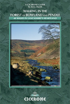
Wandelgids Forest of Bowland & Pendle - Cicerone
Er is een variëteit aan terrein in de Forest of Bowland en Pendle
Korte omschrijving
Wandelgids - Forest of Bowland & Pendle - Cicerone Productomschrijving: Deze handige gids bevat 40 verschillende circulaire dagwandelingen geschikt voor wandelaars met navigatie/ GPS vaardig...

Specificaties
- Uitgever: CICERONE Press
- ISBN-13: 9781852845155
- HOOFDCATEGORIEËN: Wandelgids
- Activiteiten: Wandelen, Hiking & Trekking
- Auteur: Terry Marsch
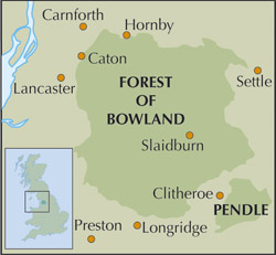
- Regio: Cumbria, England, North West England
- Land: England
- Regionale parken: Forest of Bowland
- AONB - Area of Outstanding Beauty: Forest of Bowland AONB
- Blz.: 176
- Afmeting: 12x17
- Editie: 1
- Taal: Engels
Volledige omschrijving
Wandelgids - Forest of Bowland & Pendle - Cicerone
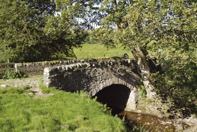
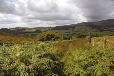
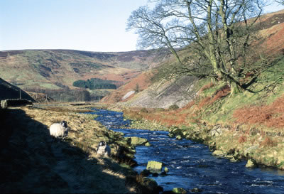
Productomschrijving: Deze handige gids bevat 40 verschillende circulaire dagwandelingen geschikt voor wandelaars met navigatie/ GPS vaardigheden. Er is een variëteit aan terrein in de Forest of Bowland en Pendle waardoor het perfect is voor diegenen die een AONB willen verkennen. Sommige van de routes bedekken inclusief: Wards Stone, Pendle Hill, Longridge. De Forest of Bowland en Pendle bieden enorm uiteenlopende terreinen – van de weelderige landerijen van de Ribble valley tot de meer ruige ruwe weiden van de Forest of Bowland.
Product description: A guidebook to 40 diverse circular day walks suitable for walkers with navigational skills. The Forest of Bowland and Pendle are two of north west England's upland AONBs, perfect for walkers who enjoy exploring rough hilly, sometimes pathless terrain. The routes include Ward's Stone, Pendle Hill, Longridge Fell and Fair Snape Fell.
Seasons:
All seasons, but suitable gear required on the tops in winter or bad weather.
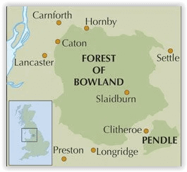
Centres:
Caton, Dunsop Bridge, Slaidburn, Whaley, Clitheroe, Chipping, Sawley, Bolton-by-Bowland, Downham.
Difficulty:
Suitable for competent walkers. Navigational skills required. Some walks are on farily remote moorland.
Must See:
The Lune and Hodder valleys, open moors and the view from Clougha Pike, Sawley Abbey, tales of witches, and historic villages like Downham, Hurst Green and Waddington.
Locatie op kaart
Overzichtskaarten

Area's of Outstanding Natural Beauty - AONB's UK
Area's of Outstanding Natural Beauty - AONB's UK

Producten op de overzichtskaart
Klik op een product om naar de detailpagina te gaan.
- Wandelgids - Guide to the Cotswolds AONB - AA
- Wandelkaart 24 - Chilterns AONB - AA
- Fietskaart- en Mtb kaart - The Cotswolds - Goldeneye
- Wandelgids - Cotswold classic walks guidebook - Goldeneye
- Wandelgids - Exploring the Cotswolds - Goldeneye
- Wandelgids - Cotswold Classic Walks - Goldeneye
- Wandelkaart - Cotswolds- Malverns & Forest of Dean - Goldeneye
- Wandelgids - The Cotswold Way 30 classic routes - Cicerone
- Wandelgids - Kent walking guide - Cicerone
- Wandelgids - North Downs Way Nat. trail - Cicerone
- Wandelgids - Chilterns walking guide - Cicerone
- Wandelgids - Suffolk coast & Heaths walks - Cicerone
- Wandelgids - North Downs Way - Map Booklet - Cicerone
- Wandelgids - North Pennines AONB walking guide - Cicerone
- Wandelgids - Ridgeway National Trail - Cicerone
- Wandelgids - Forest of Bowland & Pendle - Cicerone
- Wandelgids - Hampshire's Test Way walking guide - Cicerone
- Wandelgids & Fietsgids - The Cotswold AONB - Cicerone
- Wandelgids - Walking on the Gower - Cicerone
- Wandelgids - North Wessex Downs - Cicerone Press
- Wandelgids - Walking on the North Wessex Downs - Cicerone
- Wandelgids - Silverdale & Arnside AONB - Cicerone
- Wandelgids - North Downs Way- 246 km - Trailblazer
- Wandelkaart OL2 - Yorkshire Dales- Southern & Western Areas - OSI
- Wandelkaart OL19 - Howgill Fells and Upper Eden Valley - OSI
- Wandelkaart OL21 - South Pennines - Yorkshire - OSI
- Wandelkaart OL31 - North Pennines- Teesdale & Weardale - OSI
- Wandelkaart OL40 - The Broads - OSI
- Wandelkaart OL41 - Forest of Bowland & Ribblesdale - OSI
- Wandelkaart OL45 - The Cotswolds AONB- Gloucestershire - OSI
- Wandelkaart 108 - Lower Tamer Valley & Plymouth- Cornwall- OSI
- Wandelkaart 115 - Exmouth & Sidmouth- Devon - OSI
- Wandelkaart 137 - Ashford- Kent downs AONB- England - OSI
- Wandelkaart 140 - Quantock Hills AONB- Somerset - OSI
- Wandelkaart 140 - Quantock Hills AONB & Bridgwater- Devon - OSI
- Wandelkaart 147 - Sevenoaks & Tonbridge- Kent - OSI
- Wandelkaart 164 - Gower AONB & Gwyr- South Wales - OSI
- Wandelkaart 164 - Gower AONB & Gwyr- Wales - OSI
- Wandelkaart 171 - Chiltern Hills West & Henley-on-Thames OSI
- Wandelkaart 171 - Chiltern Hills West AONB- Wycombe - OSI
- Wandelkaart 172 - Chiltern Hills East AONB- Wycombe - OSI
- Wandelkaart 181 - Chiltern Hills AONB North- England - OSI
- Wandelkaart 181 - Chiltern Hills North AONB- Wycombe - OSI
- Wandelkaart 190 - Malvern Hills & Bredon Hill - OSI
- Wandelkaart 190 - Malvern Hills AONB & Bredon Hill - OSI
- Wandelkaart 203 - Ludlow- Shropshire Hills AONB - OSI
- Wandelkaart 217 - Long Mynd & Wenlock Edge- Schropshire- OSI
- Wandelkaart 254 - Lleyn Peninsular East- North Wales - OSI
- Wandelkaart 261 - Boston- Lincolnshire AONB - OSI
- Wandelkaart 262 - Anglesey West- Wales AONB - OSI
- Wandelkaart 263 - Anglesey East AONB- Wales - OSI
- Wandelkaart 273 - Lincolnshire Wolds South AONB - OSI
- Wandelkaart 282 - Lincolnshire Wolds North AONB - OSI
- Wandelkaart 298 - Nidderdale AONB- Yorkshire - OSI
- Wandelkaart 298 - Nidderdale AONB North Yorkshire - OSI
- Wandelkaart 300 - Howardian Hills AONB - OSI
- Wandelkaart 300 - Howardian Hills AONB & Malton - OSI
- Wandelkaart - Mourne Mountains N. Ireland - Harvey maps
- Wandelkaart - Fietskaart Forest of Bowland - Harvey maps
- Wandelkaart XT40 - Anglesey Coastal Path N. Wales - Harvey Maps
- Wandelkaart XT40 - Pennine Way Noord - Harvey Maps
- Wandelkaart XT40 - Pennine Way Zuid - Harvey Maps
- Wandelgids Cotswold - Way Two-way trekking guide - Knife Edge
- Reisgids Oxford & the Cotswolds AONB - Edicola
- Reisgids Cotswolds England - Rough Guides
- Travelguide Oxford & The Cotswolds pocket guide - Lonely Planet
- Wandelgids - The Ridgeway National trail - Trailblazer
Artikelen uit dezelfde regio

Wandelkaart 314 Solway Firth Wigton & Silloth - OSI • 9780319245668
Wandelkaart Solway Firth- Wigton & Silloth - Cumbria England Productbeschrijving: OS Explorer 314 toont de Solway Firth, Annan, Wigton en Silloth. Het omvat ook een deel van het nationale Scenic gebied van Nith estuarium, en de Solway Coast gebied van buitengewone natuurlijke schoonheid AONB. Er zijn eveneens de Cumbria Costal Way, Allerdale Ramble en deel van de Haridlan Wall Path. De OS …

Wandelgids Guide to the Lake District - AA • 9780749579432
Wandelgids - Guide to the Lake District - AA Productomschrijving: Cumbria op zich werd al eens enkel gelend voor de Lake District, maar is uiteraard veel meer dan dat. Veel van de regio houd wel degelijk deze prachitge plaats in. Een nationaal park van formaat, die geen enkel natuurliefhebber onontroerd laat. The Lake District national park, is een plaat uit de duizend in Engeland, alhoewe…

Wandelgids Silverdale & Arnside AONB - Cicerone • 9781852846282
Wandelgids - Silverdale & Arnside AONB - Cicerone Omvat: Leighton Moss, Dallam Park, Arnside Knott, Hutton Roof en Morecambe Bay Productomschrijving: Deze handige gids van 21 makkelijke dagwandelingen is gegarandeerd om u te helpen bij het verkennen van fantastische landschappen in de vorm van ruige kustpaden en betoverende bosroutes. Er zijn routes van verschillende terreinen door Le…

Wandelkaart 303 Whitehaven & Workington - OSI • 9780319245552
Wandelkaart Whitehaven & Workington - Cumbria England Omvat ook: Cockermouth & Egremont. Productbeschrijving: OS Explorer kaart 303 toont Workington en Cockermouth tot aan Calderbridge, de westelijke rand van het Lake District National Park. Hoogtepunten zijn Ennerdale Water, Whitehaven Harbour en Lank Rigg, op 541 m. De OS Explorer kaart voor Whitehaven & Workington is beschikbaar in …

Wandelkaart 103 Blackburn Burnley & Clitheroe - OSI • 9780319474266
Wandelkaart Blackburn- Burnley & Clitheroe - OSI Productbeschrijving: Kaart blad nummer 103 in de reeks van de OS Landranger kaarten, is de ideale kaart om te gebruiken bij het plannen van een dag uit rond het noordwesten van Engeland. Onderdeel van de Walliser Way in het oosten van de kaart, samen met de onderste rand van het Yorkshire Dales National Park. Andere plaatsen die zijn opgenom…