Wandelkaart 314 Solway Firth Wigton & Silloth - OSI
Solway Firth- Annan- Wigton en Silloth
Korte omschrijving
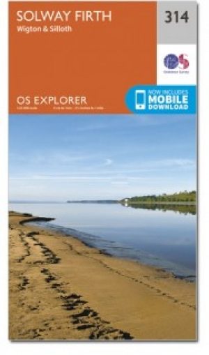
Wandelkaart Solway Firth- Wigton & Silloth - Cumbria England Productbeschrijving: OS Explorer 314 toont de Solway Firth, Annan, Wigton en Silloth. Het omvat ook een deel van het nationale Sc...

Specificaties
- Uitgever: Ordnance Survey
- ISBN-13: 9780319245668
- HOOFDCATEGORIEËN: Wandelkaart
- Activiteiten: Wandelen, Hiking & Trekking
- Regio: Cumbria, England
- Land: England
- AONB - Area of Outstanding Beauty: Solway coast AONB
- Schaal: 1:25000
- Afmeting: 13x23
- Taal: Engels
- Reeks: Explorer Series OSI
Volledige omschrijving
Wandelkaart Solway Firth- Wigton & Silloth - Cumbria England
Productbeschrijving: OS Explorer 314 toont de Solway Firth, Annan, Wigton en Silloth. Het omvat ook een deel van het nationale Scenic gebied van Nith estuarium, en de Solway Coast gebied van buitengewone natuurlijke schoonheid AONB. Er zijn eveneens de Cumbria Costal Way, Allerdale Ramble en deel van de Haridlan Wall Path. De OS Explorer kaart voor Solway Firth is beschikbaar in zowel de standaard papieren versie als de weerbestendige 'Actief' versie.
Productdiscription: OS Explorer 314 shows the Solway Firth, Annan, Wigton and Silloth. It also includes part of the National Scenic Area of Nith Estuary, and the Solway Coast Area of Outstanding Natural Beauty AONB. There's also the Cumbria Costal Way, Allerdale Ramble and part of Haridlan's Wall Path. The OS Explorer map for Solway Firth is available in both the standard paper version and weatherproof 'Active' version.
Locatie op kaart
Gekoppelde artikelen

Wandelkaart 314 Solway Firth Wigton & Silloth - OSI • 9780319245668
standaard versieWandelkaart Solway Firth- Wigton & Silloth - Cumbria England Productbeschrijving: OS Explorer 314 toont de Solway Firth, Annan, Wigton en Silloth. Het omvat ook een deel van het nationale Scenic gebied van Nith estuarium, en de Solway Coast gebied van buitengewone natuurlijke schoonheid AONB. Er zijn eveneens de Cumbria Costal Way, Allerdale Ramble en deel van de Haridlan Wall Path. De OS …

Wandelkaart 314 Solway Firth- Cumbria England - OSI • 9780319471869
weatherproof versieWandelkaart Solway Firth - Cumbria England Omvat ook: Wigton & Silloth, aansluitend ligt het NP Lake District. Productbeschrijving: OS Explorer 314 toont de Solway Firth, Annan, Wigton en Silloth. Het omvat ook een deel van het nationale Scenic gebied van Nith estuarium, en de Solway Coast gebied van buitengewone natuurlijke schoonheid AONB. Er is ook de Cumbria Costal Way, Allerdale R…
Overzichtskaarten

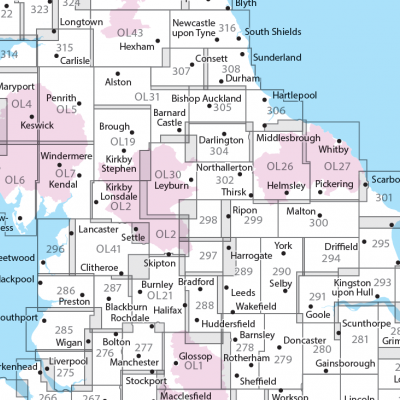
OSI Explorer & Explorer Active - Noord Engeland - Lake District
OSI Explorer & Explorer Active - Noord Engeland - Lake District

Producten op de overzichtskaart
Klik op een product om naar de detailpagina te gaan.
- Wandelkaart 275 Liverpool- South West England - OSI
- Wandelkaart 276 Bolton- Wigan & Warrington- Machester - OSI
- Wandelkaart 277 Manchester & Salford - OSI
- Wandelkaart 278 Sheffield & Barnsley- South Yorkshire - OSI
- Wandelkaart 279 Doncaster- South Yorkshire - OSI
- Wandelkaart 280 Isle of Axholme- Lincolnshire - OSI
- Wandelkaart 281 Ancholme Valley- Lincolnshire - OSI
- Wandelkaart 283 Louth & Mablethorpe- Lincolnshire - OSI
- Wandelkaart 284 Grimsby- Cleethorpes & Immingham - OSI
- Wandelkaart 285 Southport & Chorley- Merseyside - OSI
- Wandelkaart 286 Blackpool & Preston- Lancashire - OSI
- Wandelkaart 287 West Pennine Moors- Lankashire - OSI
- Wandelkaart 288 Bradford & Huddersfield- West Yorkshire - OSI
- Wandelkaart 289 Leeds- Harrogate- Wetherby & Pontefract - OSI
- Wandelkaart 290 York- Selby & Tadcaster- North Yorkshire - OSI
- Wandelkaart 291 Goole & Gilberdyke- Yorkshire - OSI
- Wandelkaart 292 Withernsea & Spurn Head- East Riding - OSI
- Wandelkaart 293 Kingston upon Hull & Beverley - OSI
- Wandelkaart 294 Market Weighton & central Yorkshire Wolds - OSI
- Wandelkaart 295 Bridlington- Driffield & Hornsea - OSI
- Wandelkaart 296 Lancaster- Morecambe & Fleetwood - OSI
- Wandelkaart 297 Lower Wharfedale & Washburn Valley - OSI
- Wandelkaart 298 Nidderdale AONB- Yorkshire - OSI
- Wandelkaart 299 Ripon & Boroughbridge- North Yorkshire - OSI
- Wandelkaart 300 Howardian Hills AONB & Malton - OSI
- Wandelkaart 301 Scarborough- Bridlington & Flamborough
- Wandelkaart 302 Northallerton & Thirsk- North Yorkshire
- Wandelkaart 303 Whitehaven & Workington - OSI
- Wandelkaart 304 Darlington & Richmond- North Cleveland
- Wandelkaart 305 Bishop Auckland & Durham - OSI
- Wandelkaart 306 Middlesbrough & Hartlepool - OSI
- Wandelkaart 307 Consett & Derwent reservoir - OSI
- Wandelkaart 308 Durham & Sunderland- England - OSI
- Wandelkaart 314 Solway Firth- Wigton & Silloth - OSI
- Wandelkaart 315 Carlisle- Brampton- Longtown - OSI
- Wandelkaart 316 Newcastle upon Tyne- Northumberland- OSI
- Wandelkaart OL2 Yorkshire Dales- Southern & Western Areas - OSI
- Wandelkaart OL19 Howgill Fells and Upper Eden Valley - OSI
- Wandelkaart OL21 South Pennines - Yorkshire - OSI
- Wandelkaart OL26 North York Moors - Western area - OSI
- Wandelkaart OL27 North York Moors- Eastern area - OSI
- Wandelkaart OL30 Yorkshire Dales - Yorkshire England - OSI
- Wandelkaart OL31 North Pennines- Teesdale & Weardale - OSI
- Wandelkaart OL41 Forest of Bowland & Ribblesdale - OSI
- Wandelkaart OL43 Hadrian's Wall - OSI

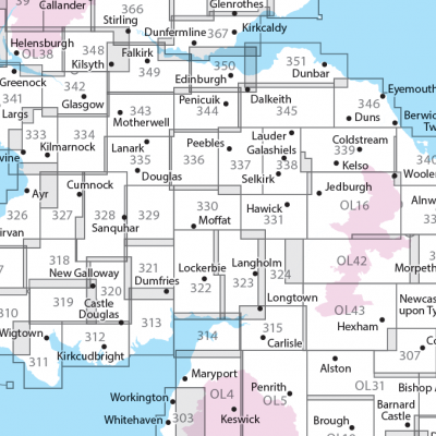
OSI Explorer & Explorer Active - Zuid Scotisch Borders
OSI Explorer & Explorer Active - Zuid Scotisch Borders

Producten op de overzichtskaart
Klik op een product om naar de detailpagina te gaan.
- Wandelkaart 307 Consett & Derwent reservoir - OSI
- Wandelkaart 308 Durham & Sunderland - England - OSI
- Wandelkaart 309 Stranraer & The Rhins - Dumfries - OSI
- Wandelkaart 310 Glenluce & Kirkcowan - Schotland - OSI
- Wandelkaart 311 Wigtown- Whithorn & The Machars - OSI
- Wandelkaart 312 Kirkcudbright & Castle Douglas - OSI
- Wandelkaart 313 Dumfries & Dalbeattie- Schotland - OSI
- Wandelkaart 314 Solway Firth- Wigton & Silloth - OSI
- Wandelkaart 315 Carlisle- Brampton & Longtown - OSI
- Wandelkaart 316 Newcastle upon Tyne - Northumberland - OSI
- Wandelkaart 137 Ballantrae South Ayrshire- Schotland- OSI
- Wandelkaart 318 Galloway Forest Park North- Ayrshire
- Wandelkaart 319 Galloway Forest Park South - OSI
- Wandelkaart 320 Castle Douglas & Loch Ken - OSI
- Wandelkaart 321 Nithsdale & Dumfries & Thornhill - OSI
- Wandelkaart 322 Annandale- Dumfries & Galoway - OSI
- Wandelkaart 323 Eskdale & Castle O'er Forest- Schotland - OSI
- Wandelkaart 324 Liddesdale & Kershope Forest - OSI
- Wandelkaart 325 Morpeth & Blyth - Northumberland - OSI
- Wandelkaart 326 Ayr & Troon - South Ayrshire - OSI
- Wandelkaart 327 Cumnock & Dalmellington - OSI
- Wandelkaart 328 Sanquhar & New Cumnock - OSI
- Wandelkaart 329 Lowther Hills- Sanquhar & Leadhills - OSI
- Wandelkaart 330 Moffat & St Mary's Loch - Dumfries - OSI
- Wandelkaart 331 Teviotdale South - Schotisch Borders - OSI
- Wandelkaart 332 Alnwick Amble - Northumberland - OSI
- Wandelkaart 333 Kilmarnock & Irvine - East Ayrshire - OSI
- Wandelkaart 334 East Kilbride- Galston & Darvel - Glasgow - OSI
- Wandelkaart 335 Lanark & Tinto Hills - South Lankashire - OSI
- Wandelkaart 336 Biggar & Broughton - South Lanarkshire - OSI
- Wandelkaart 337 Peebles & Interleithen - Schotish Borders - OSI
- Wandelkaart 338 Galashiels- Selkirk & Melrose - OSI
- Wandelkaart 339 Kelso- Coldstream & Lower Tweed Valley - OSI
- Wandelkaart 340 Holy Island & Bamburgh - OSO
- Wandelkaart 341 Greenock- Largs & Millport - OSI
- Wandelkaart 342 Glasgow Schotland - OSI
- Wandelkaart 343 Motherwell & Coatbridge- Glasgow - OSI
- Wandelkaart 344 Pentland Hills RP- Edinburgh - OSI
- Wandelkaart 345 Lammermuir Hills - Edinburgh - OSI
- Wandelkaart 346 Berwick-upon-Tweed - Northumberland - OSI
- Wandelkaart 349 Falkirk- Cumbernauld & Livingston - OSI
- Wandelkaart 350 Edinburgh - East Schotland - OSI
- Wandelkaart 351 Dunbar & North Berwick - Edinburgh - OSI
- Wandelkaart 361 Isle of Arran - OSI
- Wandelkaart 362 Cowal West & Isle of Bute - OSI
- Wandelkaart OL16 Cheviot Hills Northumberland - OSI
- Wandelkaart OL42 Kielder Water & Forest - OSI
- Wandelkaart OL43 Hadrian's Wall - OSI
- Wandelkaart OL37 Cowal East- Dunoon & Iverary - OSI
- Wandelkaart OL38 Loch Lomond South & Dumbarton - OSI
Artikelen uit dezelfde regio

Wandelkaart 89 West Cumbria England - OSI • 9780319474129
Wandelkaart West Cumbria - England Productbeschrijving: West Cumbria staat bekend om zijn aantrekkelijke landschap en het Lake District National Park & Wast Water Lake, die zich uitstrekt over 3 mijl langs de Wasdale vallei. OS Landranger kaart 89 van West Cumbria, omvat ook Cockermouth, Workington, Maryport, Dovenby, Uldale, Ennerdale Bridge, Egermont, Gosforth, Keswick, Scafell Pike, Col…

Wandelgids Lake District North - Cicerone Press • 9781786310460
Walks & scrambles Lake District North - Cicerone Productomschrijving: omvat 100 klauterroutes in het noorden van het Engelse Lake District, die Wasdale, Ennerdale, Buttermere, Borrowdale, Blencathra en Thirlmere omvatten. De gids presenteert een uitgebreide verzameling scrambles op rotsen en kieuwen, die aan elkaar zijn gekoppeld om 25 eersteklas bergdagen te vormen. De zorgvuldig gesortee…

Wandelgids Hadrian's wall Path - Knife Edge • 9781912933075
Wandelgids - Hadrian's wall Path - Knife Edge Productomschrijving: De definitieve tweerichtingsgids voor het Hadrian's Wall Path: zowel oostwaartse als westelijke routes worden volledig beschreven. 14 verschillende routes: schema's van 3, 4, 5, 6, 7, 8 en 9 dagen voor wandelaars en hardlopers. Omvat reisroutes naar het noorden en het zuiden. De moeilijkere berekeningen van tijd, afstand en…

Fietskaart Lake District NP Cumbria - Goldeneye • 9781859651841
Fietskaart Lake District NP - Goldeneye Productomschrijving: Op uw fiets op de gemakkelijke manier. Goldeneye zijn ringgebonden kaarten. De kaarten zijn water- en scheurvast, op de kaart staan plaatsen om te eten en drinken aangeduid, alsook navigatie- & referentiepunten, gemakkelijk te volgen richtingen, hoogtelijnen en doorgangsrechten. Goldeneye fiets- en wandelkaartserie zijn een zegen…

Wandelkaart XT25 Lake District Zuid Oost - Harvey maps • 9781851375486
Wandelkaart - Lake District Zuid Oost - XT25 - Harvey maps Productomschrijving: Het Lake District (Merengebied) is een nationaal park in het graafschap Cumbria in het noordwesten van Engeland. Het is een van de dertien nationale parken in het Verenigd Koninkrijk. Het zuidoosten is een bergachtige streek. Alle toppen in Engeland hoger dan 900 meter boven zeeniveau liggen in dit gebied. Het …


