Wandelkaart 275 Liverpool- South West England - OSI
Hoogtepunten zijn onder andere de Trans Pennine Trail
Korte omschrijving
Wandelkaart Liverpool - South West England Omvat ook: St Helens, Widnes & Runcorn. Productbeschrijving: OS Explorer kaart 275 omvat Liverpool, St Helens, Widnes Runcorn, alsmede de rivie...

Specificaties
- Uitgever: Ordnance Survey
- ISBN-13: 9780319244722
- HOOFDCATEGORIEËN: Wandelkaart
- Activiteiten: Wandelen, Hiking & Trekking
- Regio: North West England
- Land: England
- Schaal: 1:25000
- Afmeting: 13x23
- Taal: Engels
- Reeks: Explorer Series OSI
Volledige omschrijving
Wandelkaart Liverpool - South West England
Omvat ook: St Helens, Widnes & Runcorn.
Productbeschrijving: OS Explorer kaart 275 omvat Liverpool, St Helens, Widnes Runcorn, alsmede de rivier de Mersey. Hoogtepunten zijn onder andere de Trans Pennine Trail, Mersey way en de Liverpool circelvormige lijn. De OS Explorer kaart voor Liverpool is beschikbaar in zowel de standaard papieren versie als de weerbestendige 'Actief' versie.
Productdiscription: OS Explorer map 275 shows Liverpool, St Helens, Widnes and Runcorn, as well as the River Mersey. Highlights include the Trans Pennine Trail, Mersey Way and the Liverpool Loop Line. The OS Explorer map for Liverpool is available in both the standard paper version and weatherproof 'Active' version.
Locatie op kaart
Gekoppelde artikelen

Wandelkaart 275 Liverpool- South West England - OSI • 9780319244722
standaard versieWandelkaart Liverpool - South West England Omvat ook: St Helens, Widnes & Runcorn. Productbeschrijving: OS Explorer kaart 275 omvat Liverpool, St Helens, Widnes Runcorn, alsmede de rivier de Mersey. Hoogtepunten zijn onder andere de Trans Pennine Trail, Mersey way en de Liverpool circelvormige lijn. De OS Explorer kaart voor Liverpool is beschikbaar in zowel de standaard papieren versi…

Wandelkaart 275 Liverpool St Helens Widnes & Runcorn - OSI • 9780319471470
weatherproof versieWandelkaart Liverpool- St Helens - Widnes & Runcorn Omvat ook: St Helens, Widnes & Runcorn. Productbeschrijving: OS Explorer kaart 275 omvat Liverpool, St Helens, Widnes Runcorn, alsmede de rivier de Mersey. Hoogtepunten zijn onder andere de Trans Pennine Trail, Mersey Wayen de Liverpool run Line. De OS Explorer kaart voor Liverpool is beschikbaar in zowel de standaard papieren versie …
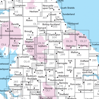
Overzichtskaarten

OSI Explorer & Explorer Active - Midden Engeland - Midlands
OSI Explorer & Explorer Active - Midden Engeland - Midlands

Producten op de overzichtskaart
Klik op een product om naar de detailpagina te gaan.
- Wandelkaart 179 Gloucester- Cheltenham & Stroud - OSI
- Wandelkaart 180 Oxford- England - OSI
- Wandelkaart 181 Chiltern Hills North AONB- Wycombe - OSI
- Wandelkaart 182 St-Albans & Hatfield- Hertfordshire - OSI
- Wandelkaart 189 Hereford & Ross-on-Wye- England - OSI
- Wandelkaart 190 Malvern Hills AONB & Bredon Hill - OSI
- Wandelkaart 191 Banbury- Bicester & Chipping Norton- OSI
- Wandelkaart 192 Buckingham & Milton Keynes - OSI
- Wandelkaart 193 Luton & Stevenage- Bedfordshire - OSI
- Wandelkaart 194 Hertford & Bishop's Stortford - OSI
- Wandelkaart 202 Leominster & Bromyard Hererfordshire - OSI
- Wandelkaart 203 Ludlow & Shropshire Hills AONB - OSI
- Wandelkaart 204 Worcester & Droitwich Spa - OSI
- Wandelkaart 205 Stratford-upon-Avon & Evesham - OSI
- Wandelkaart 206 Edge Hill & Fenny Compton - OSI
- Wandelkaart 207 Newport Pagnell & Northampton - OSI
- Wandelkaart 208 Bedford & St Neots- Bedforeshire - OSI
- Wandelkaart 209 Cambridge - England - OSI
- Wandelkaart 217 Long Mynd & Wenlock Edge - OSI
- Wandelkaart 218 Kidderminster & Wyre Forest - OSI
- Wandelkaart 219 Wolverhampton & Dudley - OSI
- Wandelkaart 220 Birmingham- West Midlands - OSI
- Wandelkaart 221 Coventry & Warwickshire - OSI
- Wandelkaart 222 Rugby & Daventry- Warwickshire - OSI
- Wandelkaart 223 Northampton & Market Harborough - OSI
- Wandelkaart 224 Corby- Kettering & Wellingborough - OSI
- Wandelkaart 225 Huntingdon & St Ives - OSI
- Wandelkaart 227 Peterborough- Cambridgeshire England - OSI
- Wandelkaart 228 March- Ely- Chatteris & Littleport - OSI
- Wandelkaart 232 Nuneaton & Tamworth- Warwickshire - OSI
- Wandelkaart 233 Leicester & Hinckley England - OSI
- Wandelkaart 234 Rutland Water & Stamford- Oakham - OSI
- Wandelkaart 235 Wisbech & Peterborough North - OSI
- Wandelkaart 241 Shrewsbury- shropshire England - OSI
- Wandelkaart 242 Telford- Ironbridge & the Wrekin - OSI
- Wandelkaart 243 Market Drayton- Schropshire - OSI
- Wandelkaart 244 Cannock Chase & Chasewater- Severn - OSI
- Wandelkaart 245 National Forest- Burton-upon-Trent - OSI
- Wandelkaart 245 National Forest - OSI
- Wandelkaart 246 Loughborough- Leicestershire England - OSI
- Wandelkaart 247 Grantham- Lincolnshire - OSI
- Wandelkaart 248 Bourne & Heckington- lincolnshire - OSI
- Wandelkaart 249 Spalding & Holbeach- Lincolnshire - OSI
- Wandelkaart 257 Crewe & Nantwich & Cheshire East - OSI
- Wandelkaart 258 Stoke-on-Trent & Newcastle-under-Lyme- OSI
- Wandelkaart 259 Derby & Utoxeter- Derbyshire - OSI
- Wandelkaart 260 Nottingham & Vale of Belvoir - OSI
- Wandelkaart 261 Boston & Lincolnshire- England - OSI
- Wandelkaart 267 Northwich & Delamere Forest - OSI
- Wandelkaart 268 Wilmslow- Macclesfield & Congleton - OSI
- Wandelkaart 269 Chesterfield & Alfreton- Derbyshire- OSI
- Wandelkaart 270 Sherwood Forest- Nottinghamshire - OSI
- Wandelkaart 271 Newark-on-Trent- Nottinghampshire - OSI
- Wandelkaart 272 Lincoln- England - OSI
- Wandelkaart 273 Lincolnshire Wolds South- England - OSI
- Wandelkaart 274 Skegness- Alford & Spilsby - OSI
- Wandelkaart 275 Liverpool- South West England - OSI
- Wandelkaart 276 Bolton- Wigan & Warrington- Machester - OSI
- Wandelkaart 277 Manchester & Salford - OSI
- Wandelkaart 278 Sheffield & Barnsley- South Yorkshire - OSI
- Wandelkaart 279 Doncaster- South Yorkshire - OSI
- Wandelkaart 280 Isle of Axholme- Lincolnshire - OSI
- Wandelkaart 281 Ancholme Valley- Lincolnshire - OSI
- Wandelkaart 282 Lincolnshire Wolds North- England - OSI
- Wandelkaart 283 Louth & Mablethorpe- Lincolnshire - OSI
- Wandelkaart 284 Grimsby- Cleethorpes & Immingham - OSI

OSI Explorer & Explorer Active - Noord Engeland - Lake District
OSI Explorer & Explorer Active - Noord Engeland - Lake District

Producten op de overzichtskaart
Klik op een product om naar de detailpagina te gaan.
- Wandelkaart 275 Liverpool- South West England - OSI
- Wandelkaart 276 Bolton- Wigan & Warrington- Machester - OSI
- Wandelkaart 277 Manchester & Salford - OSI
- Wandelkaart 278 Sheffield & Barnsley- South Yorkshire - OSI
- Wandelkaart 279 Doncaster- South Yorkshire - OSI
- Wandelkaart 280 Isle of Axholme- Lincolnshire - OSI
- Wandelkaart 281 Ancholme Valley- Lincolnshire - OSI
- Wandelkaart 283 Louth & Mablethorpe- Lincolnshire - OSI
- Wandelkaart 284 Grimsby- Cleethorpes & Immingham - OSI
- Wandelkaart 285 Southport & Chorley- Merseyside - OSI
- Wandelkaart 286 Blackpool & Preston- Lancashire - OSI
- Wandelkaart 287 West Pennine Moors- Lankashire - OSI
- Wandelkaart 288 Bradford & Huddersfield- West Yorkshire - OSI
- Wandelkaart 289 Leeds- Harrogate- Wetherby & Pontefract - OSI
- Wandelkaart 290 York- Selby & Tadcaster- North Yorkshire - OSI
- Wandelkaart 291 Goole & Gilberdyke- Yorkshire - OSI
- Wandelkaart 292 Withernsea & Spurn Head- East Riding - OSI
- Wandelkaart 293 Kingston upon Hull & Beverley - OSI
- Wandelkaart 294 Market Weighton & central Yorkshire Wolds - OSI
- Wandelkaart 295 Bridlington- Driffield & Hornsea - OSI
- Wandelkaart 296 Lancaster- Morecambe & Fleetwood - OSI
- Wandelkaart 297 Lower Wharfedale & Washburn Valley - OSI
- Wandelkaart 298 Nidderdale AONB- Yorkshire - OSI
- Wandelkaart 299 Ripon & Boroughbridge- North Yorkshire - OSI
- Wandelkaart 300 Howardian Hills AONB & Malton - OSI
- Wandelkaart 301 Scarborough- Bridlington & Flamborough
- Wandelkaart 302 Northallerton & Thirsk- North Yorkshire
- Wandelkaart 303 Whitehaven & Workington - OSI
- Wandelkaart 304 Darlington & Richmond- North Cleveland
- Wandelkaart 305 Bishop Auckland & Durham - OSI
- Wandelkaart 306 Middlesbrough & Hartlepool - OSI
- Wandelkaart 307 Consett & Derwent reservoir - OSI
- Wandelkaart 308 Durham & Sunderland- England - OSI
- Wandelkaart 314 Solway Firth- Wigton & Silloth - OSI
- Wandelkaart 315 Carlisle- Brampton- Longtown - OSI
- Wandelkaart 316 Newcastle upon Tyne- Northumberland- OSI
- Wandelkaart OL2 Yorkshire Dales- Southern & Western Areas - OSI
- Wandelkaart OL19 Howgill Fells and Upper Eden Valley - OSI
- Wandelkaart OL21 South Pennines - Yorkshire - OSI
- Wandelkaart OL26 North York Moors - Western area - OSI
- Wandelkaart OL27 North York Moors- Eastern area - OSI
- Wandelkaart OL30 Yorkshire Dales - Yorkshire England - OSI
- Wandelkaart OL31 North Pennines- Teesdale & Weardale - OSI
- Wandelkaart OL41 Forest of Bowland & Ribblesdale - OSI
- Wandelkaart OL43 Hadrian's Wall - OSI

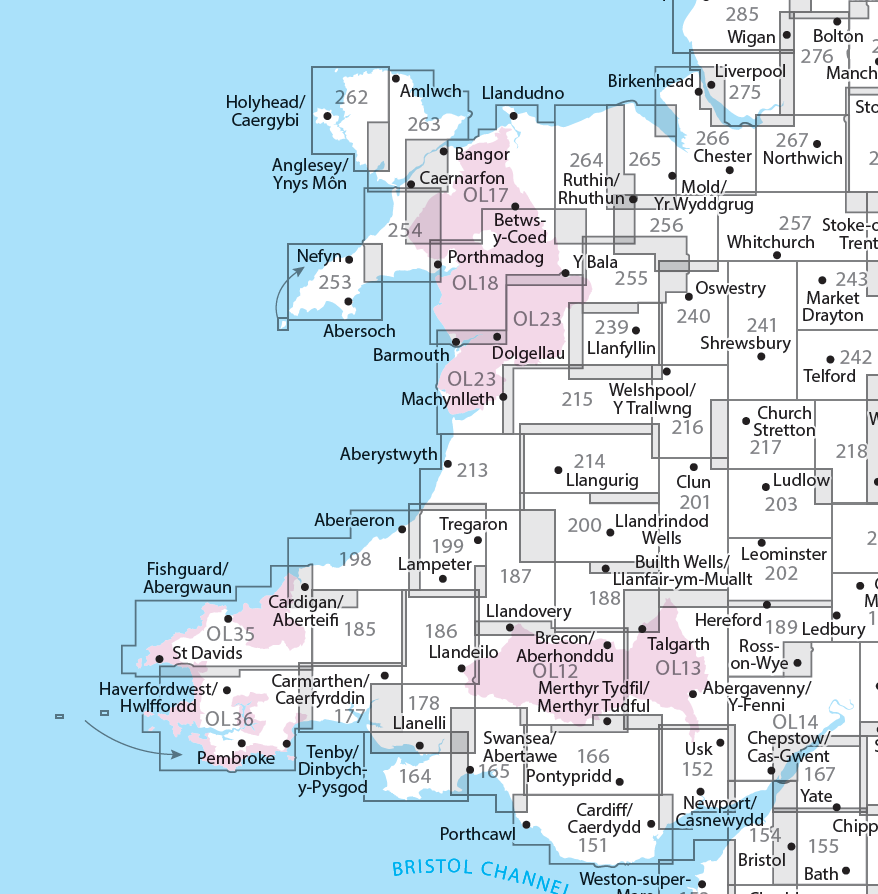
OSI Explorer & Explorer Active - Wales
OSI Explorer & Explorer Active - Wales

Producten op de overzichtskaart
Klik op een product om naar de detailpagina te gaan.
- Wandelkaart 151 Cardiff & Bridgend- Wales - OSI
- Wandelkaart 152 Newport & Pontypool- South Wales - OSI
- Wandelkaart 164 Gower AONB & Gwyr- South Wales - OSI
- Wandelkaart 165 Swansea & Abertawe- South Wales - OSI
- Wandelkaart 166 Rhondda & Merthyr Tydfil - OSI
- Wandelkaart 177 Carmarthen & Kidwelly- Wales - OSI
- Wandelkaart 178 Llanelli- Ammanford & Rhydaman - OSI
- Wandelkaart 185 Newcastle & Emly- Northumberland - OSI
- Wandelkaart 186 Llandeilo- Brechfa Forest- Wales - OSI
- Wandelkaart 187 Llandovery- South Wales - OSI
- Wandelkaart 188 Builth Wells & Llanfair-ym-Muallt - OSI
- Wandelkaart 189 Hereford & Ross-on-Wye- England - OSI
- Wandelkaart 198 Cardigan & New Quay- Wales - OSI
- Wandelkaart 199 Lampeter- Wales - OSI
- Wandelkaart 200 Llandrindod Wells & Elan Valley - OSI
- Wandelkaart 201 Knighton & Presteigne- Wales - OSI
- Wandelkaart 202 Leominster & Bromyard Hererfordshire - OSI
- Wandelkaart 203 Ludlow & Shropshire Hills AONB - OSI
- Wandelkaart 213 Aberystwyth & Cwm Rheidol - Wales - OSI
- Wandelkaart 214 Llanidloes- Newtown & Y Drenewydd - OSI
- Wandelkaart 215 Newtown & Machynlleth- Powys Wales - OSI
- Wandelkaart 216 Welshpool & Montgomery- Powys - OSI
- Wandelkaart 217 Long Mynd & Wenlock Edge - OSI
- Wandelkaart 239 Lake Vyrnwy & Efyrnwy- North Wales - OSI
- Wandelkaart 240 Oswestry & Croesoswallt- Shropshir - OSI
- Wandelkaart 241 Shrewsbury- shropshire England - OSI
- Wandelkaart 253 Lleyn Peninsula West Wales - OSI
- Wandelkaart 254 Lleyn Peninsula East- Wales - OSI
- Wandelkaart 255 Llangollen & Berwyn- West Wales - OSI
- Wandelkaart 256 Wrexham- Wrecsam & Llangollen - OSI
- Wandelkaart 257 Crewe & Nantwich & Cheshire East - OSI
- Wandelkaart 262 Anglesey West- Wales AONB - OSI
- Wandelkaart 263 Anglesey East AONB- Wales - OSI
- Wandelkaart 264 Vale of Clwyd & Dyffryn Clwyd - OSI
- Wandelkaart 265 Clwydian Range & Bryniau Clwyd - OSI
- Wandelkaart 266 Wirral- Chester & Caer- Merseyside - OSI
- Wandelkaart 267 Northwich & Delamere Forest - OSI
- Wandelkaart 275 Liverpool- South West England - OSI
- Wandelkaart OL12 Brecon Beacons NP- West & Central - OSI
- Wandelkaart OL13 Brecon Beacons NP - Eastern area - OSI
- Wandelkaart OL17 Snowdon & Conwy Valley area - OSI
- Wandelkaart OL35 North Pembrokeshire Wales - OSI
- Wandelkaart OL36 South Pembrokeshire- Wales - OSI
Artikelen uit dezelfde regio

Wandelkaart The Dales Way Yorkshire - Harvey maps • 9781851374281
Wandelkaart The Dales Way Yorkshire - Harvey maps Productomschrijving: Toont de gehele 130km (81 mijl) van The Dales Way van Ilkley in Yorkshire door de Dales via Grassington, Dent en Buckden naar Bowness on Windermere in het Lake District. Bevat alle 3 links: van Leeds, Shipley (Bradford) en Harrogate. Met informatie over het vinden van accommodatie, camping, voedsel. Tevens is de routebe…

Fietsgids Pennine Bridleway cycling - Cicerone • 9781852846558
Fietsgids Pennine Bridleway cycling - Cicerone Productomschrijving: Handige gids voor iedereen die de Walliser Bridleway National Trail wenst te fietsen. Meer dan 140km van berg fietsen die door Lancashire en de Yorkshire Dales lopen, samen met een linksom route rond de helft van de Mary Towneley Loop. 11 circulaire dag MTB routes in de Yorkshire Dales met behulp van de Bridleway zijn ook …

Wandelgids West Pennine Moors walking guide - Cicerone • 9781852845803
Wandelgids - West Pennine Moors walking guide - Cicerone Productomschrijving: Wandelen in de West Pennine Moors, beschrijft 30 wandelingen op het platteland rondom Blackburn, Darwen, Chorley en Bolton, de thuis van enkele van de meest inspirerende en opwindende wandelgebieden. De wandelingen variëren van korte, gemakkelijke scrambles tot meer uitdagende wandelingen die betrekking hebben op…

Wandelkaart 103 Blackburn Burnley & Clitheroe - OSI • 9780319474266
Wandelkaart Blackburn- Burnley & Clitheroe - OSI Productbeschrijving: Kaart blad nummer 103 in de reeks van de OS Landranger kaarten, is de ideale kaart om te gebruiken bij het plannen van een dag uit rond het noordwesten van Engeland. Onderdeel van de Walliser Way in het oosten van de kaart, samen met de onderste rand van het Yorkshire Dales National Park. Andere plaatsen die zijn opgenom…

Wandelgids Great Walks on the England Coast Path - Cicerone • 9781852849894
Great Walks on the England Coast Path - Cicerone Engelse omschrijving: At around 4500 km (2800 miles), the England Coast Path is the longest coastal trail in the world. This inspirational large-format guide presents a handpicked selection of 30 highlight sections, offering a taste of England's stunning and diverse shoreline. Routes range from 9 to 45km, spanning between 3 hours and 2 days,…


