Wandelkaart 255 Llangollen & Berwyn- West Wales - OSI
Offa's Dyke Path national trail & Upper Ceirirog Trail
Korte omschrijving
Wandelkaart Llangollen & Berwyn - West Wales Omvat ook: Ceiriog Valley. Productbeschrijving: Kaart nummerl 255 in de OS Explorer reeks beslaat een gebied in Noord Wales in het oosten van...

Specificaties
- Uitgever: Ordnance Survey
- ISBN-13: 9780319244517
- HOOFDCATEGORIEËN: Wandelkaart
- Activiteiten: Wandelen, Hiking & Trekking
- Regio: Welsh Border
- Land: Wales
- Schaal: 1:25000
- Afmeting: 13x23
- Taal: Engels
- Reeks: Explorer Series OSI
Volledige omschrijving
Wandelkaart Llangollen & Berwyn - West Wales
Omvat ook: Ceiriog Valley.
Productbeschrijving: Kaart nummerl 255 in de OS Explorer reeks beslaat een gebied in Noord Wales in het oosten van Snowdonia National Park. Hoogtepunten van het gebied zijn onder andere: Offa's Dyke Path national trail, Upper Ceirirog Trail en Llwybr Maelor way. De OS Explorer kaart voor Llangollen & Berwyn is beschikbaar in zowel de standaard papieren versie als de weerbestendige 'Actief' versie.
Productdiscription: Map sheet number 255 in the OS Explorer series covers an area in north Wales to the east of Snowdonia National Park. Highlights of the area include: Offa's Dyke Path National trail, Upper Ceirirog Trail and Llwybr Maelor Way. The OS Explorer map for Llangollen & Berwyn is available in both the standard paper version and weatherproof 'Active' version.
Locatie op kaart
Gekoppelde artikelen

Wandelkaart 255 Llangollen & Berwyn- West Wales - OSI • 9780319244517
standaard versieWandelkaart Llangollen & Berwyn - West Wales Omvat ook: Ceiriog Valley. Productbeschrijving: Kaart nummerl 255 in de OS Explorer reeks beslaat een gebied in Noord Wales in het oosten van Snowdonia National Park. Hoogtepunten van het gebied zijn onder andere: Offa's Dyke Path national trail, Upper Ceirirog Trail en Llwybr Maelor way. De OS Explorer kaart voor Llangollen & Berwyn is besc…

Wandelkaart 255 Llangollen & Berwyn - North Wales - OSI • 9780319471272
weatherproof versieWandelkaart Llangollen & Berwyn - Denbighshire Wales Omvat ook: Ceiriog Valley. Productbeschrijving: Kaart getal 255 in de OS Explorer reeks beslaat een gebied in Noord Wales in het oosten van Snowdonia National Park. Hoogtepunten van het gebied zijn onder andere: Offa's Dyke Path nationale trail, Upper Ceirirog Trail en Llwybr Maelor Way. De OS Explorer kaart voor Llangollen & Berwyn …
Overzichtskaarten

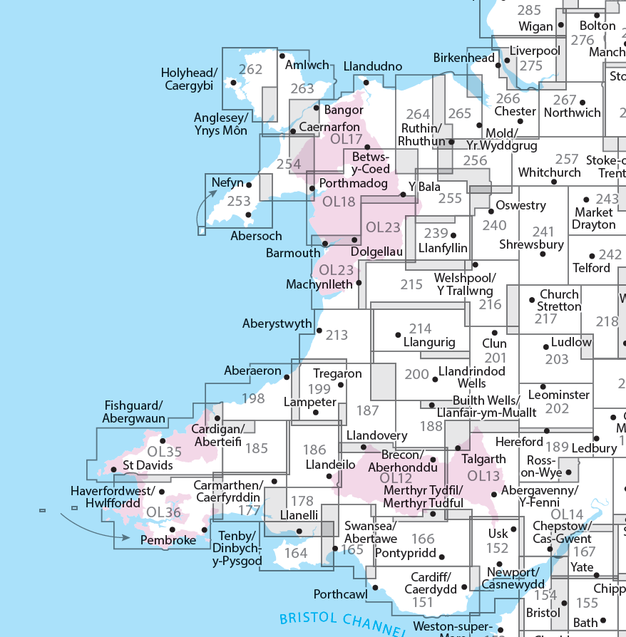
OSI Explorer & Explorer Active - Wales
OSI Explorer & Explorer Active - Wales

Producten op de overzichtskaart
Klik op een product om naar de detailpagina te gaan.
- Wandelkaart 151 Cardiff & Bridgend- Wales - OSI
- Wandelkaart 152 Newport & Pontypool- South Wales - OSI
- Wandelkaart 164 Gower AONB & Gwyr- South Wales - OSI
- Wandelkaart 165 Swansea & Abertawe- South Wales - OSI
- Wandelkaart 166 Rhondda & Merthyr Tydfil - OSI
- Wandelkaart 177 Carmarthen & Kidwelly- Wales - OSI
- Wandelkaart 178 Llanelli- Ammanford & Rhydaman - OSI
- Wandelkaart 185 Newcastle & Emly- Northumberland - OSI
- Wandelkaart 186 Llandeilo- Brechfa Forest- Wales - OSI
- Wandelkaart 187 Llandovery- South Wales - OSI
- Wandelkaart 188 Builth Wells & Llanfair-ym-Muallt - OSI
- Wandelkaart 189 Hereford & Ross-on-Wye- England - OSI
- Wandelkaart 198 Cardigan & New Quay- Wales - OSI
- Wandelkaart 199 Lampeter- Wales - OSI
- Wandelkaart 200 Llandrindod Wells & Elan Valley - OSI
- Wandelkaart 201 Knighton & Presteigne- Wales - OSI
- Wandelkaart 202 Leominster & Bromyard Hererfordshire - OSI
- Wandelkaart 203 Ludlow & Shropshire Hills AONB - OSI
- Wandelkaart 213 Aberystwyth & Cwm Rheidol - Wales - OSI
- Wandelkaart 214 Llanidloes- Newtown & Y Drenewydd - OSI
- Wandelkaart 215 Newtown & Machynlleth- Powys Wales - OSI
- Wandelkaart 216 Welshpool & Montgomery- Powys - OSI
- Wandelkaart 217 Long Mynd & Wenlock Edge - OSI
- Wandelkaart 239 Lake Vyrnwy & Efyrnwy- North Wales - OSI
- Wandelkaart 240 Oswestry & Croesoswallt- Shropshir - OSI
- Wandelkaart 241 Shrewsbury- shropshire England - OSI
- Wandelkaart 253 Lleyn Peninsula West Wales - OSI
- Wandelkaart 254 Lleyn Peninsula East- Wales - OSI
- Wandelkaart 255 Llangollen & Berwyn- West Wales - OSI
- Wandelkaart 256 Wrexham- Wrecsam & Llangollen - OSI
- Wandelkaart 257 Crewe & Nantwich & Cheshire East - OSI
- Wandelkaart 262 Anglesey West- Wales AONB - OSI
- Wandelkaart 263 Anglesey East AONB- Wales - OSI
- Wandelkaart 264 Vale of Clwyd & Dyffryn Clwyd - OSI
- Wandelkaart 265 Clwydian Range & Bryniau Clwyd - OSI
- Wandelkaart 266 Wirral- Chester & Caer- Merseyside - OSI
- Wandelkaart 267 Northwich & Delamere Forest - OSI
- Wandelkaart 275 Liverpool- South West England - OSI
- Wandelkaart OL12 Brecon Beacons NP- West & Central - OSI
- Wandelkaart OL13 Brecon Beacons NP - Eastern area - OSI
- Wandelkaart OL17 Snowdon & Conwy Valley area - OSI
- Wandelkaart OL35 North Pembrokeshire Wales - OSI
- Wandelkaart OL36 South Pembrokeshire- Wales - OSI


