
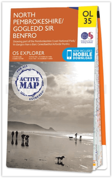
Wandelkaart OL35 North Pembrokeshire Wales - OSI
St Davids - Cardigan - Goodwick & Fishguard
Korte omschrijving
Wandelkaart North Pembrokeshire Wales - OSI Productomschrijving: Kaart nummer OL35 in de OS Explorer serie bestrijkt de kust van North Pembrokeshire en het Pembrokeshire Coast National Park ...

Specificaties
- Uitgever: Ordnance Survey
- ISBN-13: 9780319475744
- HOOFDCATEGORIEËN: Wandelkaart
- Activiteiten: Wandelen, Hiking & Trekking
- Regio: Pembrokeshire, Wales
- Land: Wales
- Waterafstotende kaart: Ordnance Survey ACTIVE Explorer Weatherproof Maps
- Nationale parken: Pembrokeshire Coast NP, Wales
- Schaal: 1:25000
- Afmeting: 13x24
- Taal: Engels
- Reeks: Explorer ACTIVE Series OSI
Volledige omschrijving
Wandelkaart North Pembrokeshire Wales - OSI
Productomschrijving: Kaart nummer OL35 in de OS Explorer serie bestrijkt de kust van North Pembrokeshire en het Pembrokeshire Coast National Park aan de westkust van Wales. Hoogtepunten van het gebied zijn: St Davids, Cardigan, Goodwick en Fishguard, samen met het Pembrokeshire Coast Path.
National Trails and recreation paths:
* Ceredigion Coast path * Pembrokeshire Coas path * Landsker Borderlands trail * Wales Coast PathEngelse omschrijving: Map sheet OL35 in the OS Explorer series covers the North Pembrokeshire coast and the Pembrokeshire Coast National Park on the West coast of Wales. Highlights of the area include: St Davids, Cardigan, Goodwick and Fishguard, along with the Pembrokeshire Coast Path. Also on the map is: St Davids, Cardigan, Goodwick, and Fishguard, and the Pembrokeshire Coast Path.

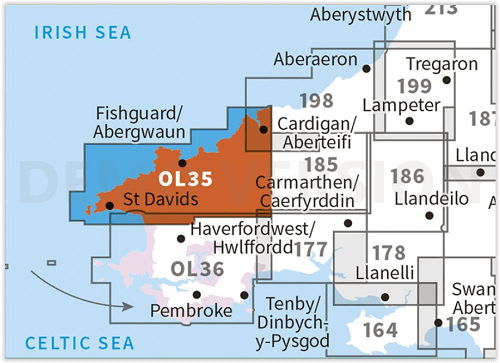
Locatie op kaart
Overzichtskaarten

OSI Explorer & Explorer Active - Wales
OSI Explorer & Explorer Active - Wales

Producten op de overzichtskaart
Klik op een product om naar de detailpagina te gaan.
- Wandelkaart 151 Cardiff & Bridgend- Wales - OSI
- Wandelkaart 152 Newport & Pontypool- South Wales - OSI
- Wandelkaart 164 Gower AONB & Gwyr- South Wales - OSI
- Wandelkaart 165 Swansea & Abertawe- South Wales - OSI
- Wandelkaart 166 Rhondda & Merthyr Tydfil - OSI
- Wandelkaart 177 Carmarthen & Kidwelly- Wales - OSI
- Wandelkaart 178 Llanelli- Ammanford & Rhydaman - OSI
- Wandelkaart 185 Newcastle & Emly- Northumberland - OSI
- Wandelkaart 186 Llandeilo- Brechfa Forest- Wales - OSI
- Wandelkaart 187 Llandovery- South Wales - OSI
- Wandelkaart 188 Builth Wells & Llanfair-ym-Muallt - OSI
- Wandelkaart 189 Hereford & Ross-on-Wye- England - OSI
- Wandelkaart 198 Cardigan & New Quay- Wales - OSI
- Wandelkaart 199 Lampeter- Wales - OSI
- Wandelkaart 200 Llandrindod Wells & Elan Valley - OSI
- Wandelkaart 201 Knighton & Presteigne- Wales - OSI
- Wandelkaart 202 Leominster & Bromyard Hererfordshire - OSI
- Wandelkaart 203 Ludlow & Shropshire Hills AONB - OSI
- Wandelkaart 213 Aberystwyth & Cwm Rheidol - Wales - OSI
- Wandelkaart 214 Llanidloes- Newtown & Y Drenewydd - OSI
- Wandelkaart 215 Newtown & Machynlleth- Powys Wales - OSI
- Wandelkaart 216 Welshpool & Montgomery- Powys - OSI
- Wandelkaart 217 Long Mynd & Wenlock Edge - OSI
- Wandelkaart 239 Lake Vyrnwy & Efyrnwy- North Wales - OSI
- Wandelkaart 240 Oswestry & Croesoswallt- Shropshir - OSI
- Wandelkaart 241 Shrewsbury- shropshire England - OSI
- Wandelkaart 253 Lleyn Peninsula West Wales - OSI
- Wandelkaart 254 Lleyn Peninsula East- Wales - OSI
- Wandelkaart 255 Llangollen & Berwyn- West Wales - OSI
- Wandelkaart 256 Wrexham- Wrecsam & Llangollen - OSI
- Wandelkaart 257 Crewe & Nantwich & Cheshire East - OSI
- Wandelkaart 262 Anglesey West- Wales AONB - OSI
- Wandelkaart 263 Anglesey East AONB- Wales - OSI
- Wandelkaart 264 Vale of Clwyd & Dyffryn Clwyd - OSI
- Wandelkaart 265 Clwydian Range & Bryniau Clwyd - OSI
- Wandelkaart 266 Wirral- Chester & Caer- Merseyside - OSI
- Wandelkaart 267 Northwich & Delamere Forest - OSI
- Wandelkaart 275 Liverpool- South West England - OSI
- Wandelkaart OL12 Brecon Beacons NP- West & Central - OSI
- Wandelkaart OL13 Brecon Beacons NP - Eastern area - OSI
- Wandelkaart OL17 Snowdon & Conwy Valley area - OSI
- Wandelkaart OL35 North Pembrokeshire Wales - OSI
- Wandelkaart OL36 South Pembrokeshire- Wales - OSI
Artikelen uit dezelfde regio

Wandelkaart 158 Tenby & Pembroke - Wales - OSI • 9780319474815
Wandelkaart Tenby & Pembroke in Pembrokeshire Wales Productbeschrijving: Deze OS Landranger kaart 158 omvat Tenby & Pembroke, alsook Kilgetty, Freystrop, Yerbeston, Milford Haven, Wolfsdale, Llandissilio, het Nationaal Park van Pembrokeshire Coast en de Pembrokeshire Coast Path. De OS Landranger kaarten reeks heeft betrekking op Groot-Brittannië met 204 gedetailleerde kaarten, perfect voo…

Wandelkaart 157 St-David's & Haverfordwest Wales - OSI • 9780319262559
Wandelkaart St-David's & Haverfordwest - Wales - OSI Productbeschrijving: Pembrokeshire Coast Path op OS Landranger kaart 157, volgt de iconische kustlijn rond de landtong en St. Brides Bay, de traditionele Welsh steden van Pembroke, Milford Haven, Haverfordwest, St. David's en Goodwick passeren. De OS Landranger kaarten reeks heeft betrekking op Groot-Brittannië met 204 gedetailleerde kaa…
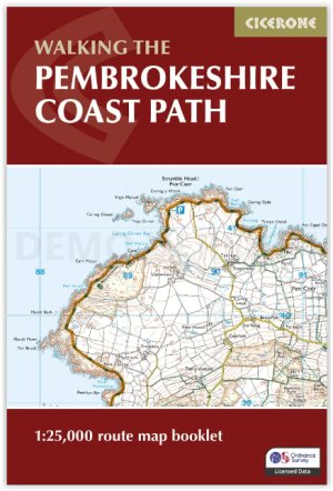
Map Nooklet Pembrokeshire Coast Path - Cicerone • 9781786312099
Pembrokeshire Coast Path - Cicerone Productomschrijving: OPGELET: Dit art. zit standard inbegrepen in de wandelgids van de route zelf. Pembrokeshire Coast Path National Trail, van 291 km langs de kust van de regio Pembrokeshire NP wales. Deze omvat de kaartjes boekje voor de route. Engelse omschrijving: Map of the 182 mile (291km) Pembrokeshire Coast Path National Trail, between …
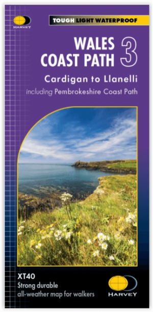
Wandelkaart XT40 Wales Coast Path 3 - Cardigan to LIanelli • 9781851376629
Wandelkaart Wales Coast Path 3 - Cardigan to LIanelli Productomschrijving: Het officiële pad is 300 kilometer, oftewel 186 mijl, en loopt van Amroth naar St. Dogmaels. Het Pembrokeshire Coast Path is een onderdeel van het Wales Coast Path, dat 1400 kilometer, oftewel 870 mijl, lang is en de gehele kust van Wales passeert. Het Pembrokeshire Coast Path passeert 58 stranden en 14 havens. …

Wandelgids Pembrokeshire Tenby & the south - Cicerone • 9781786311757
Pembrokeshire Tenby & the south - Cicerone Productomschrijving: 15 van de beste korte wandelingen in Tenby en South Pembrokeshire. Onze gids is voorzien van goed leesbare Ordnance Survey-kaarten en duidelijke routebeschrijvingen, perfect als je voor het eerst gaat wandelen of op zoek bent naar iets waar je met het hele gezin van kunt genieten. Engelse omschrijving: 15 of the best short…