
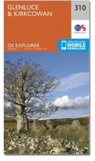
Wandelkaart 310 Glenluce & Kirkcowan Schotland - OSI
Kirkcowan- Luce Bay en de Southern Upland Way
Korte omschrijving
Wandelkaart Glenluce & Kirkcowan - Dumfries & Galoway 310 / Glenluce & Kirkcowan, Dumfries & Galoway - In het zuidwesten van Schotland, toont deze OS Explorer kaart 310 Glenluce en Kirkcowan...

Specificaties
- Uitgever: Ordnance Survey
- ISBN-13: 9780319245620
- HOOFDCATEGORIEËN: Wandelkaart
- Activiteiten: Wandelen, Hiking & Trekking
- Regio: Dumfries & Galloway, Schotland
- Land: Schotland
- Schaal: 1:25000
- Afmeting: 13x23
- Taal: Engels
- Reeks: Explorer Series OSI
Volledige omschrijving
Wandelkaart Glenluce & Kirkcowan - Dumfries & Galoway
310 / Glenluce & Kirkcowan, Dumfries & Galoway - In het zuidwesten van Schotland, toont deze OS Explorer kaart 310 Glenluce en Kirkcowan, Luce Bay en de Southern Upland Way. De OS Explorer kaart voor Glenluce & Kirkcowan is beschikbaar in zowel de standaard papieren versie als weerbestendige 'Actief' versie.
310 / Glenluce & Kirkcowan, Dumfries & Galoway - In Scotland's South-West, OS Explorer Map 310 shows Glenluce and Kirkcowan, Luce Bay and the Southern Upland Way. The OS Explorer map for Glenluce & Kirkcowan is available in both the standard paper version and weatherproof 'Active' version.
Locatie op kaart
Gekoppelde artikelen

Wandelkaart 310 Glenluce & Kirkcowan Schotland - OSI • 9780319245620
standaard versieWandelkaart Glenluce & Kirkcowan - Dumfries & Galoway 310 / Glenluce & Kirkcowan, Dumfries & Galoway - In het zuidwesten van Schotland, toont deze OS Explorer kaart 310 Glenluce en Kirkcowan, Luce Bay en de Southern Upland Way. De OS Explorer kaart voor Glenluce & Kirkcowan is beschikbaar in zowel de standaard papieren versie als weerbestendige 'Actief' versie. 310 / Glenluce & Kirkcow…

Wandelkaart 310 Glenluce & Kirkcowan- Schotland - OSI • 9780319471821
weatherproof versieWandelkaart Glenluce & Kirkcowan - Dumfries & Galloway Productbeschrijving: In Schotland in het zuidwesten toont OS Explorer kaart 310 Glenluce en Kirkcowan, Luce Bay en de Southern Upland Way. De OS Explorer kaart voor Glenluce & Kirkcowan is beschikbaar in zowel de standaard papieren versie als de weerbestendige 'Actief' versie. Productdiscription: In Scotland's South-West, OS Explor…
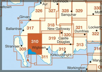
Overzichtskaarten

OSI Explorer & Explorer Active - Zuid Scotisch Borders
OSI Explorer & Explorer Active - Zuid Scotisch Borders

Producten op de overzichtskaart
Klik op een product om naar de detailpagina te gaan.
- Wandelkaart 307 Consett & Derwent reservoir - OSI
- Wandelkaart 308 Durham & Sunderland - England - OSI
- Wandelkaart 309 Stranraer & The Rhins - Dumfries - OSI
- Wandelkaart 310 Glenluce & Kirkcowan - Schotland - OSI
- Wandelkaart 311 Wigtown- Whithorn & The Machars - OSI
- Wandelkaart 312 Kirkcudbright & Castle Douglas - OSI
- Wandelkaart 313 Dumfries & Dalbeattie- Schotland - OSI
- Wandelkaart 314 Solway Firth- Wigton & Silloth - OSI
- Wandelkaart 315 Carlisle- Brampton & Longtown - OSI
- Wandelkaart 316 Newcastle upon Tyne - Northumberland - OSI
- Wandelkaart 137 Ballantrae South Ayrshire- Schotland- OSI
- Wandelkaart 318 Galloway Forest Park North- Ayrshire
- Wandelkaart 319 Galloway Forest Park South - OSI
- Wandelkaart 320 Castle Douglas & Loch Ken - OSI
- Wandelkaart 321 Nithsdale & Dumfries & Thornhill - OSI
- Wandelkaart 322 Annandale- Dumfries & Galoway - OSI
- Wandelkaart 323 Eskdale & Castle O'er Forest- Schotland - OSI
- Wandelkaart 324 Liddesdale & Kershope Forest - OSI
- Wandelkaart 325 Morpeth & Blyth - Northumberland - OSI
- Wandelkaart 326 Ayr & Troon - South Ayrshire - OSI
- Wandelkaart 327 Cumnock & Dalmellington - OSI
- Wandelkaart 328 Sanquhar & New Cumnock - OSI
- Wandelkaart 329 Lowther Hills- Sanquhar & Leadhills - OSI
- Wandelkaart 330 Moffat & St Mary's Loch - Dumfries - OSI
- Wandelkaart 331 Teviotdale South - Schotisch Borders - OSI
- Wandelkaart 332 Alnwick Amble - Northumberland - OSI
- Wandelkaart 333 Kilmarnock & Irvine - East Ayrshire - OSI
- Wandelkaart 334 East Kilbride- Galston & Darvel - Glasgow - OSI
- Wandelkaart 335 Lanark & Tinto Hills - South Lankashire - OSI
- Wandelkaart 336 Biggar & Broughton - South Lanarkshire - OSI
- Wandelkaart 337 Peebles & Interleithen - Schotish Borders - OSI
- Wandelkaart 338 Galashiels- Selkirk & Melrose - OSI
- Wandelkaart 339 Kelso- Coldstream & Lower Tweed Valley - OSI
- Wandelkaart 340 Holy Island & Bamburgh - OSO
- Wandelkaart 341 Greenock- Largs & Millport - OSI
- Wandelkaart 342 Glasgow Schotland - OSI
- Wandelkaart 343 Motherwell & Coatbridge- Glasgow - OSI
- Wandelkaart 344 Pentland Hills RP- Edinburgh - OSI
- Wandelkaart 345 Lammermuir Hills - Edinburgh - OSI
- Wandelkaart 346 Berwick-upon-Tweed - Northumberland - OSI
- Wandelkaart 349 Falkirk- Cumbernauld & Livingston - OSI
- Wandelkaart 350 Edinburgh - East Schotland - OSI
- Wandelkaart 351 Dunbar & North Berwick - Edinburgh - OSI
- Wandelkaart 361 Isle of Arran - OSI
- Wandelkaart 362 Cowal West & Isle of Bute - OSI
- Wandelkaart OL16 Cheviot Hills Northumberland - OSI
- Wandelkaart OL42 Kielder Water & Forest - OSI
- Wandelkaart OL43 Hadrian's Wall - OSI
- Wandelkaart OL37 Cowal East- Dunoon & Iverary - OSI
- Wandelkaart OL38 Loch Lomond South & Dumbarton - OSI
Artikelen uit dezelfde regio

Wandelkaart 84 Dumfries & Castle Douglas Schotland - OSI • 9780319261828
Wandelkaart Dumfries & Castle Douglas - Schotland Productbeschrijving: OS Landranger kaart 84 toont Dumfries & Castle Douglas, en omvat ook Parton, Crossmicheal, Shawhead, Tokaj, Kirkcudbright, Ringford en deel van de Galloway Forest Park. De kust rond de Solway Firth is aangewezen en Area of Outstanding Natural Beauty - AONB De OS Landranger kaarten reeks heeft betrekking op Groot-Bri…

Wandelkaart 319 Galloway Forest Park South - OSI • 9780319471913
Wandelkaart Galloway Forest Park South - Schotland Omvat ook: Glen Trool & Clatteringshaws Loch Newton Stewart. Productbeschrijving: OS Explorer kaart 319 toont het zuidelijke deel van het Galloway Forest park, Clatteringshaws Loch, Southern Upland Way, E2 Europese Long Distance pad, Loch Grannoch en Loch Ken. De OS Explorer kaart voor Galloway Forest Park South is beschikbaar in zowel…

Wandelkaart 311 Wigtown Whithorn & The Machars - OSI • 9780319245637
Wandelkaart Wigtown- Whithorn - Dumfries & Galloway Productbeschrijving: OS Explorer kaart 331 omvat Whithorn en The Machars. De Machars zijn een gebied met glooiende groene heuvels waarvan sommige met belangrijke vroege oude nederzettingen. Wigton Bay is een Site van bijzonder wetenschappelijk belang zowel als een natuurreservaat terwijl Luce Bay een speciale beschermingszone is. De OS Ex…

Wandelkaart 329 Lowther Hills- Sanquhar & Leadhills - OSI • 9780319245811
Wandelkaart Lowther Hills- Sanquhar & Leadhills - Schotland Omvat ook: Wanlockhead & Crawford Productomschrijving: OS Explorer kaart 329 omvat de Lowther Hills, Daer Water en Daer Resevoir, Sanquhar en Leadhills. Verder wordt de Southern Upland Way getoont, evenals een onderdeel van de E2 Europese Long Distance pad. Dit gebied beschikt ook over het hoogstgelegen dorp in Schotland - Wan…

Wandelkaart 324 Liddesdale & Kershope Forest - Schotland • 9780319475324
Wandelkaart Liddesdale & Kershope Forest - Schotsich borders Omvat ook: Newcastleton & Canonbie. Productbeschrijving: Aan de Schots / engelsee grens, omvat OS Explorer kaart 324 de omgevingen van Kershope bos en het Liddel Water. De Hermitage Castle in de buurt van Liddel Water is één van de best bewaarde in Schotland. De OS Explorer kaart voor Liddesdale & Kershope Forest is beschikba…