
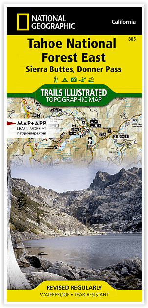
Wandelkaart 805 Tahoe Nat. Forest East - Sierra Buttes - Nat Geo
French Meadows - New Bullards Bar - Granite Chief Wilderness
Korte omschrijving
Tahoe National Forest East - Sierra Buttes - Nat Geo Omvat: Donner Pass, Eldorado National Forest, Granite Chief Wilderness, Mosquito Ridge, Plumas National Forest, Sawtooth Ridge, Tahoe Nat...

Specificaties
- Uitgever: National Geographic
- ISBN-13: 9781566953818
- HOOFDCATEGORIEËN: Wandelkaart
- Activiteiten: Wandelen, Hiking & Trekking
- Regio: Californië, USA
- Land: Verenigde Staten van Amerika (USA)
- Waterafstotende kaart: Nat Geo waterproof series
- Schaal: 1:63360
- Afmeting: 10x19
- Taal: Engels
Volledige omschrijving
Tahoe National Forest East - Sierra Buttes - Nat Geo
Omvat: Donner Pass, Eldorado National Forest, Granite Chief Wilderness, Mosquito Ridge, Plumas National Forest, Sawtooth Ridge, Tahoe National Forest, Truckee.
Engelse omschrijving: Expertly researched and created in partnership with the U.S. Forest Service and others, National Geographic's Trails Illustrated map of Yuba and American Rivers region of Tahoe National Forest provides an unparalleled tool for exploring this historically significant region of the Sierras. Whatever the season, you'll find this map a useful tool in pursuing a host of recreational activities from skiing and snowmobiling to camping and boating. The map features many key points of interest, including French Meadows and New Bullards Bar Reservoirs, Granite Chief Wilderness, South Yuba River Recreation Area, Malakoff Diggins State Historic Park, Donner Memorial State Park and the western rim of the Lake Tahoe Basin Management Unit.
The Tahoe National Forest West map can guide you off the beaten path and back again with miles of clearly marked trails including portions of the Pacific Crest, Pioneer, and Tahoe Rim trails. To help you choose the path that's right for you, trails are color coded according to the designated usage and mileage between intersections is indicated. The Yuba Donner scenic byways is noted for those wishing to take in the scenery by car. Many recreation features are noted as well, including ski areas, campgrounds, trailheads, wildlife viewing areas, boat launches, and swimming and fishing areas. The map base includes contour lines and elevations for summits, passes and many lakes.
Every Trails Illustrated map is printed on "Backcountry Tough" waterproof, tear-resistant paper. A full UTM grid is printed on the map to aid with GPS navigation.
Locatie op kaart
Overzichtskaarten

NAT GEO California trail maps
NAT GEO California trail maps

Producten op de overzichtskaart
Klik op een product om naar de detailpagina te gaan.
- Wandelkaart 205 Sequoia & Kings Canyon NP - California
- Wandelkaart 206 Yosemite NP - California - Nat Geo
- Wandelkaart 218 Redwood National & State Parks - Nat Geo
- Wandelkaart 221 Death Valley NP - Nevada - Natgeo
- Wandelkaart 226 Joshua Tree NP - California - Nat Geo
- Wandelkaart 256 Mojave National park California - Nat Geo
- Wandelkaart 306 Yosemite SW- Yosemite Valley - Nat Geo
- Wandelkaart 307 Yosemite NP North West - Nat Geo
- Wandelkaart 308 Yosemite NE- Tuolumne Meadows - Nat Geo
- Wandelkaart 309 Yosemite SE - Ansel Adams Wilderness - Nat Geo
- Wandelkaart 322 Mount Whitney California - Nat Geo
- Wandelkaart 803 Lake Tahoe Basin - California - Nat Geo
- Wandelkaart 804 Tahoe National Forest West - Nat Geo
- Wandelkaart 805 Tahoe Nat. Forest East - Sierra Buttes - Nat Geo
- Wandelkaart 809 Mammoth Lakes - Mono Divide - Nat Geo
- Wandelkaart 810 Shaver Lake - Sierra National Forest - Nat Geo
Artikelen uit dezelfde regio

Reisgids The Rough Guide to California - Rough Guides • 9781839058592
The Rough Guide to California - Rough Guides Productomschrijving: De volledig bijgewerkte The Rough Guide to California is de definitieve gids voor de meest bezochte staat in de VS. Ontdek de hoogtepunten van Californië met prachtige fotografie, gemakkelijk te gebruiken kaarten en meer lijsten en informatie dan ooit tevoren. De Rough Guide to California bevat leuke en avontuurlijke reisrou…
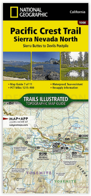
Wandelkaart 1008 Pacific Crest Trail - Nat Geo • 9781566957908
Wandelkaart Pacific Crest Trail - Nat Geo Productomschrijving: De Pacific Crest Trail, die in de topografische kaartengids voor de Sierra Nevada North staat aangegeven, loopt door subalpiene bossen en vulkanische rotsformaties en blijft dicht bij de Sierra Crest. De John Muir Trail loopt 160 mijl samen met de PCT en splitst zich in het westen van de PCT bij Tuolumne Meadows in Yosemite Nat…

Reisgids California wine country USA - Top 10 - Eyewitness • 9781409326823
California wine country USA - Top 10 - Eyewitness Productomschrijving: Explore California's world-class wineries, take a leisurely tour on the Napa Valley Wine Train, cycle along the Silverado Trail or venture to the Russian River for the renowned River Jazz and Blues Festival. From Top 10 festivals to the Top 10 beaches - discover the best of California Wine Country with this easy-to-use …

Wandelgids Hiking the Pacific Crest Trail - Cicerone • 9781852849207
Hiking the Pacific Crest Trail - PCT - Cicerone Productomschrijving: Een wandelgids over de Pacific Crest Trail (PCT), een epische wandeling van 3300 km van de Mexicaanse grens naar het Canadese British Columbia. Een van 's werelds beste wandelingen, de route loopt door Californië, Oregon en de staat Washington, langs de Mojave-woestijn, High Sierras, Cascades en talloze meer wilde bergen …

Reisgids L'essentiel de Californie - Lonely Planet • 9782816171204
L'essentiel de Californie du Lonely Planet Description de produits: Le guide Lonely Planet qui va à l'essentiel, pour découvrir le meilleur de la Californie. Un guide tout en couleurs, illustré par des centaines de photos. Sonoma Valley, la Pacific Coast Highway, Yosemite, les parcs à thème, San Francisco, Lake Tahoe, Death Valley… tous les incontournables de la région réunis dans ce volum…