
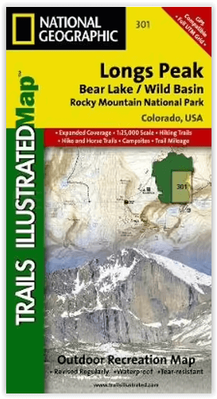
Wandelkaart 301 Longs Peak -Trails Illustrated N. Trails - Nat Geo
Bear Lake / Wild Basin / Rocky Mountain NP
Korte omschrijving
Wandelkaart 301 Longs Peak - Nat Geo Productomschrijving: Engelse omschrijving: Towering over the Rocky Mountains stands the 14,259 foot high Longs Peak. National Geographic's Trails Il...

Specificaties
- Uitgever: National Geographic
- ISBN-13: 9781566954310
- HOOFDCATEGORIEËN: Wandelkaart
- Activiteiten: Wandelen, Hiking & Trekking
- Regio: Colorado, USA
- Land: Verenigde Staten van Amerika (USA)
- Nationale parken: Rocky Mountain NP, Colorado USA
- Schaal: 1:25000
- Afmeting: 10x19
- Taal: Engels
Volledige omschrijving
Wandelkaart 301 Longs Peak - Nat Geo
Productomschrijving:
Engelse omschrijving: Towering over the Rocky Mountains stands the 14,259 foot high Longs Peak. National Geographic's Trails Illustrated map of Longs Peak and the surrounding south-east areas of Rocky Mountain National Park is designed to meet the needs of those who are looking for a phenomenal climbing experience as well as for all outdoor enthusiasts. Expertly researched and created in partnership with local land management agencies, this map features key points of interest including Bear Lake, Wild Basin, Moraine Park , Glacier Basin, the privately owned MacGregor Ranch Conservation Easement and the western edge of the Roosevelt National Forest.
With extensive detail of Longs Peak and miles of clearly marked trails, scenic byways lakes and creeks, the map can guide you off the beaten path and back again. The clearly marked trails include mileages between intersections. The map base includes contour lines and elevations for summits and passes. Some of the many recreation features include: visitor centers, campgrounds, backcountry campsites, trailheads, and interpretive trails.
Every Trails Illustrated map is printed on "Backcountry Tough" waterproof, tear-resistant paper. A full UTM grid is printed on the map to aid with GPS navigation. Other features found on this map include: Longs Peak, Rocky Mountain National Park, Roosevelt National Forest.
Locatie op kaart
Overzichtskaarten
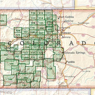
NAT GEO Colorado trail maps
NAT GEO Colorado trail maps
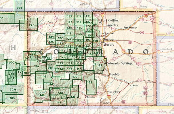
Producten op de overzichtskaart
Klik op een product om naar de detailpagina te gaan.
- Wandelkaart 110 Leadville & Fairplay - Colorado - Nat Geo
- Wandelkaart 127 Aspen - Independence Pass - Colorado USA
- Wandelkaart 137 Pikes Peak & Cañon City - Nat Geo
- Wandelkaart 138 Sangre de Cristo Mountains - Nat Geo
- Wandelkaart 139 La Garita Caldera - Cochetopa - Nat Geo
- Wandelkaart 140 Weminuche Wilderness Colorado USA - Nat Geo
- Wandelkaart 141 Telluride- Silverton- Ouray & Lake City - Nat Geo
- Wandelkaart 144 Durango & Cortez- Colorado - Natgeo
- Wandelkaart 200 Rocky Mountain NP- Colorado - Nat Geo
- Wandelkaart 208 Colorado National Monument - Natgeo
- Wandelkaart 245 Black Canyon of the Gunnison NP - Natgeo
- Wandelkaart 301 Longs Peak -Trails Illustrated N. Trails - Nat Geo
- Wandelkaart 601 Aspen Local Trails - Nat Geo

NAT GEO Montana trails map
NAT GEO Montana trails map

Producten op de overzichtskaart
Klik op een product om naar de detailpagina te gaan.
- Wandelkaart 215 Glacier & Waterton Lakes NP - Montana - Nat Geo
- Wandelkaart 301 Longs Peak -Trails Illustrated N. Trails - Nat Geo
- Wandelkaart 302 Yellowstone NP & Old Faithful - Nat Geo
- Wandelkaart 303 Mammoth Hot Springs- Yellowstone - Nat Geo
- Wandelkaart 304 Tower & Canyon Yellowstone NP - Nat Geo
- Wandelkaart 306 Yosemite SW- Yosemite Valley - Nat Geo
- Wandelkaart 314 Many Glacier NP- Waterton lakes - Montana
Artikelen uit dezelfde regio

Wandelkaart 139 La Garita Caldera - Cochetopa - Nat Geo • 9781566953399
TOPO Wandelkaart 139 - La Garita Caldera - Cochetopa - National Gepgraphic Productomschrijving: La Garita Caldera is de krater van een grote dode vulkaan in het zuidwesten van Colorado in de Verenigde Staten. De caldera, een ringvormige bergketen die centraal binnen een cluster van kleinere caldera's ligt, maakt deel uit van het San Juan Gebergte in de Rocky Mountains. Engelse omschrij…

Wandelkaart 208 Colorado National Monument - Natgeo • 9781566954013
TOPO Wandelkaart 208 - Colorado National Monument - Natgeo Productomschrijving: recreatie regio's doorheen Colorado's 'Grand Valley' omvatten de steden: Grand Junction, Fruita, Palisade & Loma. Dit veel gebruikte gebied is gekend onder de de mensen die in Colorado wonen. Dit gebied is nationaal bekend voor zijn speciale mountainbiketrails en evengoed gekend voor de start van het Kokepelli …

Wandelkaart 144 Durango & Cortez- Colorado - Natgeo • 9781566954631
TOPO Wandelkaart 144 - Durango & Cortez- Colorado - Natgeo Productomschrijving: Deze kaart biedt u alle soorten routes aan in de regio tussen Durango & Cortez in Colrado. UIteraard hebben wij het hier over de wandelroutes, maar eveneens kan er hier aan moutainbiken worden gedaan, of paardrijden op dezelfde routes. Engelse omschrijving: National Geographic's Trails Illustrated map of D…

Reisgids Colorado USA - Lonely Planet • 9781787016811
Reisgids Colorado - Lonely Planet Productomschrijving: Spectaculaire vergezichten, eindeloze poedersneeuwafdalingen en bergstadjes met echo's van het Oude Westen - Colorado is een plek die al heel lang mensen tot avontuur uitnodigt. Lonely Planet brengt je naar het hart van Colorado, met geweldige reiservaringen en het beste planningsadvies. Ga de pistes op in Aspen, ontdek het Oude Westen…
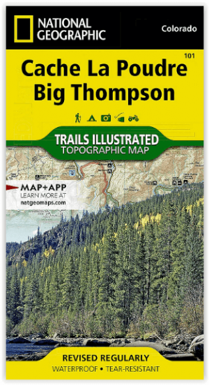
Wandelkaart 101 Cache La Poudre- Big Thompson Colorado - Nat Geo • 9781566953900
Cache La Poudre, Big Thompson Colorado - Nat Geo Productomschrijving: Canyon Lakes Ranger District, dat is het bezienswaardige bosgebied, of zeg maar wildernis gebied dat naast Fort Collins Colorado ligt. Outdoor enthousiastelingen die willen genieten van de recreatieve mogelijkheden net ten oosten van Rocky Mountain National Park zullen National Geographic's Trails Illustrated kaart van C…