
Wandelkaart 215 Glacier & Waterton Lakes NP - Montana - Nat Geo
Glacier NP sluit nadeloos aan op het Canadese Waterten Lakes NP
Korte omschrijving
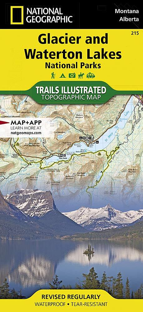
TOPO Wandelkaart 215 - Glacier & Waterton Lakes NP Productomschrijving: Glacier National Park is een nationaal park in de Amerikaanse staat Montana. Het park sluit nadeloos aan op het Canade...

Specificaties
- Uitgever: National Geographic
- ISBN-13: 9781566953184
- HOOFDCATEGORIEËN: Wandelkaart
- Activiteiten: Wandelen, Hiking & Trekking
- Regio: Alberta, Canada, Montana, USA
- Land: Canada, Verenigde Staten van Amerika (USA)
- Nationale parken: Wateron Lakes NP Alberta Canada
- Schaal: 1:100000
- Afmeting: 10x19
- Taal: Engels
Volledige omschrijving
TOPO Wandelkaart 215 - Glacier & Waterton Lakes NP
Productomschrijving: Glacier National Park is een nationaal park in de Amerikaanse staat Montana. Het park sluit nadeloos aan op het Canadese Waterten Lakes NP net over de grens in Alberta Canada. Het park ligt in de Rocky Mountains op de grens met Canada. Zes bergtoppen bereiken er een hoogte van meer dan 3000 meter.
Engelse omschrijving: National Geographic's Trails Illustrated map of Glacier and Waterton Lakes National Parks offers unparalleled detail for outdoor enthusiasts exploring the pristine landscape of forests, mountains, lakes, and meadows within these two spectacular parks. Created in partnership with local land management agencies, this expertly researched map features key areas of interest including Many Glacier, Great Bear Wilderness, Flathead National Forest, Hungry Horse Reservoir, Lake McDonald, Flathead River, St. Mary Lake, Akamina-Kishinena Provincial Park, and the Waterton Lakes.
The Glacier and Waterton Lakes map is an invaluable resource for exploring the more than 800 miles of mapped trails within the parks, including the Pacific Northwest Trail, the Continental Divide Trail, and recommended biking trails. Recreation features are clearly marked, including campgrounds, trailheads, interpretive trails, fishing and boat access, and horse rental locations. The map base includes contour lines and elevations for summits, passes and major lakes. A variety of helpful information about recreation activities available in the parks, hiking and backcountry camping, regulations, and safety tips are included as well. Every Trails Illustrated map is printed on "Backcountry Tough" waterproof, tear-resistant paper. A full UTM grid is printed on the map to aid with GPS navigation.
Other features found on this map include: Apgar Mountains, Bowman Lake, Flathead National Forest, Flathead Range, Glacier, Great Bear Wilderness, Kintla Lake, Lake McDonald, Lake Sherburne, Lewis & Clark National Forest, Lewis Range, Livingston Range, Lower Saint Mary Lake, Mount Carter, Mount Cleveland, Mount Saint Nicholas, Mount Stimson, Saint Mary Lake, Upper Waterton Lake, Whitefish Lake.
Locatie op kaart
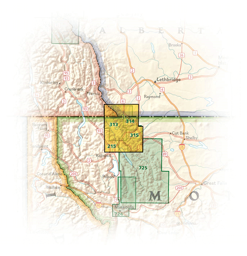
Overzichtskaarten

NAT GEO Montana trails map
NAT GEO Montana trails map

Producten op de overzichtskaart
Klik op een product om naar de detailpagina te gaan.
- Wandelkaart 215 Glacier & Waterton Lakes NP - Montana - Nat Geo
- Wandelkaart 301 Longs Peak -Trails Illustrated N. Trails - Nat Geo
- Wandelkaart 302 Yellowstone NP & Old Faithful - Nat Geo
- Wandelkaart 303 Mammoth Hot Springs- Yellowstone - Nat Geo
- Wandelkaart 304 Tower & Canyon Yellowstone NP - Nat Geo
- Wandelkaart 306 Yosemite SW- Yosemite Valley - Nat Geo
- Wandelkaart 314 Many Glacier NP- Waterton lakes - Montana
Artikelen uit dezelfde regio

Wandelkaart 723 Bozeman- Big Sky & Bridger Range - Natgeo • 9781566956802
TOPO Wandelkaart 723 - Bozeman- Big Sky & Bridger Range Productomschrijving: Bozeman Pass is een bergpas gelegen ongeveer 21 km ten oosten van Bozeman, Montana en ongeveer 24 km ten westen van Livingston, Montana. It verdeeld de Bridger & Gallatin bergmassieven. Engelse omschrijving: Located just north of Yellowstone National Park, Absaroka-Beartooth Wilderness is known for it high pea…

Reisgids Canada Ouest 24-2025 - Le Routard • 9782017888352
Reisgids West-Canada - Hachette Productomschrijving: Ondoordringbare bossen bewoond door zwarte beren, hoge bergen met besneeuwde toppen weerspiegeld in smaragdgroene meren, adembenemende panorama's... Of je nu in de voetsporen van de pioniers treedt of de nationale parken van de Rocky Mountains bezoekt, je zult een ontmoeting hebben met het Grote Westen die de mythe waarmaakt! Franse …

Wandelgids Rocky Mountains & Pacific Northwest NP - Lonely Planet • 9781838696085
Rocky Mountains & Pacific Northwest NP - Lonely Planet Productomschrijving: Lonely Planet's Rocky Mountains and the Pacific Northwest's National Parks is uw paspoort voor het meest actuele advies over wat je moet zien en overslaan. Beklim Grand Teton, bespioneer wilde dieren en kampeer bij Crater Lake, allemaal met je vertrouwde reisgenoot. Duik in het hart van de Rocky Mountains en de nat…

Wandelkaart 15 Bow Lake & Saskatchewan river Crossing - Gem Trek • 9781990161087
Wandelkaart Bow Lake & Saskatchewan river Crossing - Gem Trek Productomschrijving: Deze Gem Trek kaart voldoet aan de behoeften van bezoekers die de Bow Lake en Saskatchewan Crossing regio van Banff National Park willen verkennen. Of je nu over de wegen toert of het binnenland intrekt, de waterdichte en scheurbestendige kaart van Bow Lake & Saskatchewan Crossing is van onschatbare waarde. …
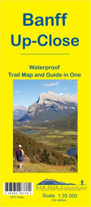
Wandelkaart 11 Banff Up-Close - Gemtrek • 9781895526776
Wandelkaart - Banff Up-Close - Gemtrek Productomschrijving: Banff, een begrip in Alberta en wereldwijd, als skigebied en als wandelgebied in de zomermaanden. Banff heeft maar een klein stukje dat echt kan worden betreden als skigebied, de meerderheid van de skiërs gaan in de richting van Lake Louis zo'n 35km verder richting Jasper National park, die zelf zo'n 400km van Banff ligt. In Banff…