
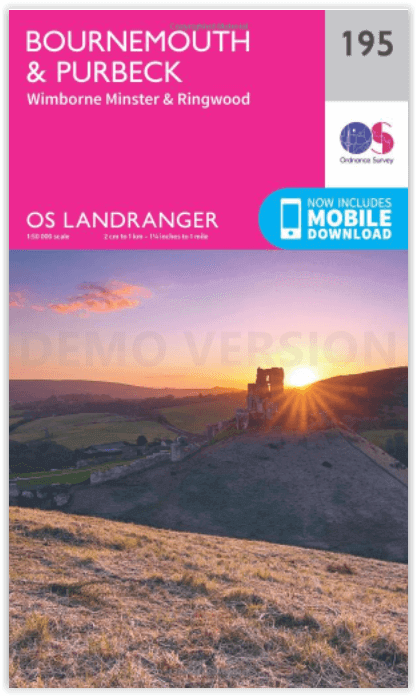
Wandelkaart 195 Bournemouth & Purbeck- SW England - OSI
Bournemouth- Poole Bay- Poole Harbour & Isle van Purbeck
Korte omschrijving
Wandelkaart Bournemouth & Purbeck - SW England Productbeschrijving: Kaart nummer 195 in de OS Landranger kaart reeks heeft betrekking op de kust van Dorset, Bournemouth, Poole Bay, Poole Har...

Specificaties
- Uitgever: Ordnance Survey
- ISBN-13: 9780319262931
- HOOFDCATEGORIEËN: Wandelkaart
- Activiteiten: Wandelen, Hiking & Trekking
- Regio: South West England
- Land: England
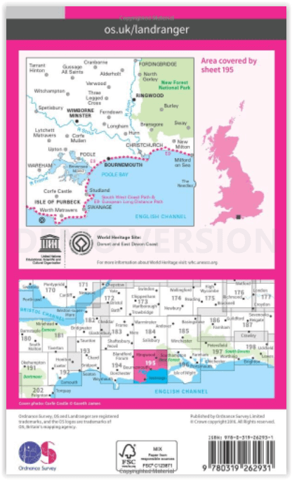
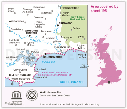
- UNESCO werelderfgoed: Dorset & East Devon Coast, England UK
- Schaal: 1:50000
- Afmeting: 13x23
- Taal: Engels
- Reeks: Landranger Series OSI
Volledige omschrijving
Wandelkaart Bournemouth & Purbeck - SW England
Productbeschrijving: Kaart nummer 195 in de OS Landranger kaart reeks heeft betrekking op de kust van Dorset, Bournemouth, Poole Bay, Poole Harbour, Isle van Purbeck, de Purbeck Hills, Swanage, Christchurch Bay, Ringwood, Wimborne Minster, New Milton, Milford on Sea, Wareham en Corfe Castle. Ook inbegrepen is meest oostelijke gelegen gedeelte van het Zuid-Westelijk gelegen Cast pad en het Nationaalpark New Forest, Sway, Burley en Fordingbridge.
De OS Landranger kaarten reeks heeft betrekking op Groot-Brittannië met 204 gedetailleerde kaarten, perfect voor dagtochten en korte pauzes. Elke kaart bevat alle informatie die u nodig heeft om dit lokaal gebied te leren kennen en omvat plaatsen van belang, toeristische informatie, picknickplaatsen en campings, plus doorgangsrechten informatie voor Engeland en Wales.
Productdiscription: Map sheet number 195 in the OS Landranger map series covers the Dorset coast, Bournemouth, Poole Bay, Poole Harbour, Isle of Purbeck, the Purbeck Hills, Swanage, Christchurch Bay, Ringwood, Wimborne Minster, New Milton, Milford on Sea, Wareham and Corfe Castle. Also included is the eastern most section of the South West Cast Path and the western area of the New Forest National Park, Sway, Burley and Fordingbridge.
The OS Landranger Map series covers Great Britain with 204 detailed maps, perfect for day trips and short breaks. Each map provides all the information you need to get to know your local area and includes places of interest, tourist information, picnic areas and camp sites, plus Rights of Way information for England and Wales.
Locatie op kaart
Gekoppelde artikelen

Wandelkaart 195 Bournemouth & Purbeck- SW England - OSI • 9780319262931
standaard versieWandelkaart Bournemouth & Purbeck - SW England Productbeschrijving: Kaart nummer 195 in de OS Landranger kaart reeks heeft betrekking op de kust van Dorset, Bournemouth, Poole Bay, Poole Harbour, Isle van Purbeck, de Purbeck Hills, Swanage, Christchurch Bay, Ringwood, Wimborne Minster, New Milton, Milford on Sea, Wareham en Corfe Castle. Ook inbegrepen is meest oostelijke gelegen gedeelte …

Wandelkaart 195 Bournemouth & Purbeck - OSI • 9780319475188
weatherproof versieWandelkaart Bournemouth & Purbeck - S.W. England Productbeschrijving: Kaart nummer 195 in de OS Landranger kaart reeks heeft betrekking op de kust van Dorset, Bournemouth, Poole Bay, Poole Harbour, Isle van Purbeck, de Purbeck Hills, Swanage, Christchurch Bay, Ringwood, Wimborne Minster, New Milton, Milford on Sea, Wareham en Corfe Castle. Ook inbegrepen is de meeste oostelijke gedeelte va…
Overzichtskaarten

Artikelen met UNESCO Werelderfgoed locaties
Artikelen met UNESCO Werelderfgoed locaties

Producten op de overzichtskaart
Klik op een product om naar de detailpagina te gaan.
- Wandelkaart 10047 - Aurland- Sogn og Fjordane - Nordeca AS
- Fietsgids - A vélo en Ardèche méridionale - 46 balades - Glénat
- Wandelgids Rheinsteig - Rheinburgenweg & höhenwegen - Rother
- Wandelgids Pfälzer Weitwanderwege & Weinsteig - Rother
- Wandelkaart XT25 - Yorkshire Dales Zuid-Oost - Harvey maps
- Wandelkaart XT40 - N.O. Yorkshire Dales NP - Harvey ultramaps
- Wandelkaart XT40 - N.W. Yorkshire Dales NP - Harvey Ultramaps
- Wandelkaart XT40 - Z.O. Yorkshire Dales England - Harvey Maps
- Wandelkaart XT40 - Z.W. Yorkshire Dales - Harvey Ultramaps
- Wandelkaart 3713 ET - Pays de Bitche & PNR des Vosges du Nord
- Fietsgids - Canal du Midi cycling - Cicerone
- Wandelgids Japan's Kumano Kodo Pelgrimage - Cicerone
- Wandelgids - The Pennine Way Map Booklet - Cicerone
- Fietsgids Bedevaart Ruta Via de la Plata cycle route - Cicerone
- Wandelgids - Italy's Cinque Terre walking - Cicerone
- Guide de voyage - Angkor en quelques jours - Lonely Planet
- Guide de voyage - Angkor en quelques jours - Lonely Planet
- Wandelkaart 229 - Salzkammergut - Kompass
- Wandelkaart 204 Truro & Falmouth- Cornwall England - OSI
- Wandelkaart 005 - Mont Perdu & Gavarnie - Sua Editions
- Wandelkaart 0/16 - Mount Kenya Nationalpark - Alpenverrein
- Travelguide - Angkor Wat & Siem Reap pocket guide - Lonely Planet
- Wandelgids Tour of the Jungfrau - Cicerone
- Wandelkaart Geopark Harz - Braunschweiger Land - Huber
- Wandelkaart XT25 - Yorkshire Dales NP Noord-Oost - Harvey maps
- Wandelkaart - South West Coast Path 5 - Harvey maps
- Wandelgids - Wanderführer Dolomiten 1 - Hikeline
- Wandelgids - Wanderführer Dolomiten 2 - Hikeline
- Wandelgids - Ostfriesland Duitsland - Rother
- Wandelgids - Pfälzerwald & Deutsche Weinstrasse - Rother
- Wandelgids Drakensberg - 75 day walks - Cicerone
- Fietskaart & wandelkaart 368 - Rhein Radweg 3 - Publipress
- Wandelgids & klimgids - Berner Alpen 4- Jungfrau Region - SAC
- Wandelgids - Hadrian's Wall Path - Rucksack readres
- Wandelkaart - Hadrian's Wall Path - Harvey maps
- Wandelkaart - South West Coast Path 1 - Harvey maps
- Wandelkaart - South West Coast Path 3 - Harvey maps
- Wandelkaart - South West Coast Path 4 - Harvey maps
- Wandelkaart - South West Coast Path 6 - Harvey maps
- Wandelkaart XT25 - Yorkshire Dales Zuid-West - Harvey Maps
- Wandelkaart 194 - Dorchester & Weymouth- Dorset - OSI
- Wandelkaart 179 - Canterbury- East Kent - England - OSI
- Wandelkaart 195 - Bournemouth & Purbeck- SW England - OSI
- Wandelkaart 193 - Taunton & Lyme Regis- Somerset - OSI
- Wandelkaart 2241 SB - Albi & Cordes-sur-Ciel - IGN
- Wandelkaart 179 - Canterbury & East Kent - England - OSI
- Wandelkaart 247t - Sardona Graubünden - Swisstopo
- Fietsgids Bikeline - Neusiedler See - Radweg - Estenbauer
- Wandelkaart 2136 ET - Rocamadour & Padirac - IGN
- Wandelgids - Massif Central (week-end) à pied - Ed. Chamina
- Wandelkaart 2137 SB - Gramat & Rocamadour - IGN
- Compostelle en France nouveaux chemins- Ed.Ouest France
- Wandelkaart 2138 OT - Cahors & St-Cirq-Lapopie - IGN

OSI Landranger & Landranger Active - Zuid Engeland & London
OSI Landranger & Landranger Active - Zuid Engeland & London

Producten op de overzichtskaart
Klik op een product om naar de detailpagina te gaan.
- Wandelkaart 194 Dorchester & Weymouth- Dorset - OSI
- Wandelkaart 194 Dorchester & Weymouth- Dorset - OSI
- Wandelkaart 195 Bournemouth & Purbeck - OSI
- Wandelkaart 195 Bournemouth & Purbeck- SW England - OSI
- Wandelkaart 196 The Solent & Isle of Wight - OSI
- Wandelkaart 196 The Solent & Isle of Wight - OSI
- Wandelkaart 197 Chichester & The South Downs NP - OSI
- Wandelkaart 197 Chichester & The South Downs NP - OSI
- Wandelkaart 198 Brighton & Lewes- Sussex England - OSI
- Wandelkaart 198 Brighton & Lewes & Haywards Heath - OSI
- Wandelkaart 199 Eastbourne & Hastings- Sussex - OSI
- Wandelkaart 199 Eastbourne & Hastings- Battle - OSI
- Wandelkaart 183 Yeovil & Frome- Somerset England - OSI
- Wandelkaart 183 Yeovil & Frome- Somerset England - OSI
- Wandelkaart 184 Salisbury & The Plain- Wiltshire England - OSI
- Wandelkaart 184 Salisbury & The Plain- Wiltshire England - OSI
- Wandelkaart 185 Winchester & Basingstoke - England - OSI
- Wandelkaart 185 Winchester & Basingstoke - England - OSI
- Wandelkaart 186 Aldershot & Guildford - England - OSI
- Wandelkaart 186 Aldershot & Guildford - England - OSI
- Wandelkaart 187 Dorking & Reigate- Surrey England - OSI
- Wandelkaart 187 Dorking- Reigate & Crawley - OSI
- Wandelkaart 188 Maidstone & Royal Tunbridge Wells - OSI
- Wandelkaart 188 Maidstone & Royal Tunbridge Wells - OSI
- Wandelkaart 189 Ashford & Romney Marsh - England - OSI
- Wandelkaart 189 Ashford & Romney Marsh - Kent - OSI
- Wandelkaart 172 Bristol & Bath- S.W. England - OSI
- Wandelkaart 172 Bristol- Bath & Thornbury- S.W. England - OSI
- Wandelkaart 173 Swindon & Devizes- England - OSI
- Wandelkaart 173 Swindon- Devizes & Marlborough - OSI
- Wandelkaart 174 Newbury & Wantage- England - OSI
- Wandelkaart 174 Newbury- Wantage & Hungerford - OSI
- Wandelkaart 175 Reading & Windsor- S.E. England - OSI
- Wandelkaart 175 Reading- Windsor & Bracknell - OSI
- Wandelkaart 176 West London & Rickmansworth - OSI
- Wandelkaart 176 West London & Rickmansworth - OSI
- Wandelkaart 177 Billericay East London & Gravesend - OSI
- Wandelkaart 178 Thames Estuary & Rochester - OSI
- Wandelkaart 178 Thames Estuary- Medway London - OSI
- Wandelkaart 179 Canterbury & East Kent - England - OSI
- Wandelkaart 179 Canterbury & East Kent - England - OSI
- Wandelkaart 162 Gloucester & Forest Dean - OSI
- Wandelkaart 163 Cheltenham & Cirencester- England - OSI
- Wandelkaart 163 Cheltenham & Cirencester- England - OSI
- Wandelkaart 164 Oxford & Chipping Norton - OSI
- Wandelkaart 164 Oxford & Chipping Norton- England - OSI
- Wandelkaart 165 Aylesbury & Leighton Buzzard - OSI
- Wandelkaart 165 Aylesbury & Leighton Buzzard - OSI
- Wandelkaart 166 Luton- Hertford & Hitchin - OSI
- Wandelkaart 166 Luton- Hertford & Hitchin- Bedfordshire - OSI
- Wandelkaart 167 Chelmsford & Harlow- Essex England - OSI
- Wandelkaart 167 Chelmsford- Harlow & Bishop's - OSI
- Wandelkaart 168 Colchester- Halstead & Maldon - OSI
- Wandelkaart 168 Colchester- Halstead & Maldon- England - OSI
- Wandelkaart 169 Ipswich & The Naze- England - OSI
- Wandelkaart 169 Ipswich & The Naze- England - OSI
- Wandelkaart 149 Hereford & Leominster- England - OSI
- Wandelkaart 149 Hereford & Leominster- England - OSI
- Wandelkaart 150 Worcester & The Malverns - OSI
- Wandelkaart 150 Worcester & The Malverns- England - OSI
- Wandelkaart 151 Stratford-upon-Avon & Warwick - England - OSI
- Wandelkaart 151 Stratford-upon-Avon- England - OSI
- Wandelkaart 152 Northampton & Milton Keynes - OSI
- Wandelkaart 152 Northampton & Milton Keynes - OSI
- Wandelkaart 153 Bedford & Huntingdon- England - OSI
- Wandelkaart 153 Bedford- Huntingdon & St-Neots- England - OSI
- Wandelkaart 154 Cambridge & Newmarket - OSI
- Wandelkaart 154 Cambridge & Newmarket- England - OSI
- Wandelkaart 155 Bury St Edmunds & Stowmarket - OSI
- Wandelkaart 155 Bury St Edmunds & Sudbury - OSI
Artikelen uit dezelfde regio

Wandelgids Great Walks on the England Coast Path - Cicerone • 9781852849894
Great Walks on the England Coast Path - Cicerone Engelse omschrijving: At around 4500 km (2800 miles), the England Coast Path is the longest coastal trail in the world. This inspirational large-format guide presents a handpicked selection of 30 highlight sections, offering a taste of England's stunning and diverse shoreline. Routes range from 9 to 45km, spanning between 3 hours and 2 days,…

Wandelkaart South West Coast Path 5 - Harvey maps • 9781851374427
Wandelkaart - South West Coast Path 5 - Harvey maps Productomschrijving: Waterdichte XT40 kaart van Harvey. Een ideale kaart voor wandelaars op de langste en op één van haar meest populairste nationale routes. Het loopt langs de kust van Somerset, Cornwall en Devon, Dorset van Minehead round via Land's end naar Poole. Het omvat alle 95 mijls van het World Heritage site bekend als de Jurass…

Wandelkaart 103 The Lizard Cornwall England - OSI • 9780319243053
Wandelkaart The Lizard - South west England - OSI Omvat ook: Falmouth & Helston. Productbeschrijving: Kaart nummer 103 in de OS Explorer kaarten reeks is de ideale kaart voor het verkennen van The Lizard, Falmouth en Helston. Hoogtepunten van het gebied zijn onder andere: Falmouth, Goonhilly Downs, Mullion Cove, Lizard Point, Bumble Rock, Cornwall Maritime Museum, Porthleven en de Sout…

Wandelkaart South West Coast Path 2 - Harvey maps • 9781851376827
South West Coast Path 2 - Harvey maps Productomschrijving: Het South West Coast path is een 1014 km lang langeafstandspad en het langste nationale pad in Engeland. Het pad strekt zich uit van Minehead in Somerset tot Poole in Dorset, inclusief Land's End en de prachtige zuidkust van Cornwall. Dit deel van de route brengt u van St-Ives naar Plymouth. Engelse omschrijving: The Sou…

Wandelkaart 172 Bristol & Bath S.W. England - OSI • 9780319262702
Wandelkaart Bristol & Bath - South West England Productbeschrijving: OS Landranger kaart 172 toont Bristol, de rivier de Avon, de Georgische stad Bath en de zuidkant van de Cotswolds way. De Romeinse badhuizen zijn het hoogtepunt van de stad, maar niet te missen zijn de diverse voorgestelde wandeltochten die wijzen naar het mooiste van de regio De OS Landranger kaarten reeks heeft betrekki…