
Wandelkaart South West Coast Path 2 - Harvey maps
St-Ives naar Plymouth

Korte omschrijving
South West Coast Path 2 - Harvey maps Productomschrijving: Het South West Coast path is een 1014 km lang langeafstandspad en het langste nationale pad in Engeland. Het pad strekt zich uit va...

Specificaties
- Uitgever: HARVEY MAPS
- ISBN-13: 9781851376827
- HOOFDCATEGORIEËN: Wandelkaart
- Activiteiten: Wandelen, Hiking & Trekking
- Regio: South West England
- Land: England
- Lange afstand wandelroutes: South West Coast Path - SWCP (1014 km)
- Schaal: 1:40000
- Afmeting: 14x25
- Taal: Engels
- Reeks: Superwalker XT40, Harvey Maps
Volledige omschrijving
South West Coast Path 2 - Harvey maps
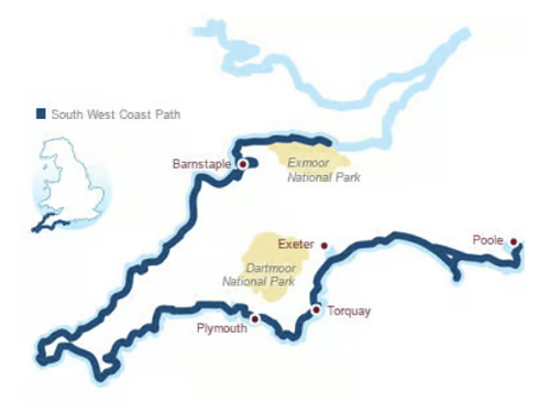
Productomschrijving: Het South West Coast path is een 1014 km lang langeafstandspad en het langste nationale pad in Engeland. Het pad strekt zich uit van Minehead in Somerset tot Poole in Dorset, inclusief Land's End en de prachtige zuidkust van Cornwall. Dit deel van de route brengt u van St-Ives naar Plymouth.
Engelse omschrijving: The South West Coast path is a 1014km (630mile) long distance path and the longest National Trail in England. The path stretches from Minehead in Somerset to Poole in Dorset, including Land's End and Cornwall's stunning south coast.
- This updated Trail Map covers the second section of the South West Coast Path from St-Ives to Plymouth which is 282 km (181.5 miles).
- The entire route on 3 sheets. This is map 2 of 3.
- A good two weeks walking on one map.
- The XT40 is based on original HARVEY mapping with all the detail a walker would expect on a map at 1:40,000 scale.
- Clear and easy to read mapping which is uncluttered by information irrelevant to the walker.
- Printed on tough, light and 100% waterproof paper, less than half the weight of a laminated map.
- Shows facilities and services along the route.
Overzichtskaarten

Harvey Maps - Mountain XT40 Maps
Harvey Maps - Mountain XT40 Maps

Producten op de overzichtskaart
Klik op een product om naar de detailpagina te gaan.
- Wandelkaart Yorkshire Dales NP - Harvey Maps
- Wandelkaart Assynt & Coigach - Harvey Maps
- Wandelkaart Ben Nevis and Glen Coe Schotland - Harvey maps
- Wandelkaart Brecon Beacons NP - Harvey maps
- Wandelkaart Cairngorms National Park - Harvey maps
- Wandelkaart Dark Peak- Peak District NP England - Harvey maps
- Wandelkaart Dartmoor National Park - Harvey maps
- Wandelkaart Knoydart - Kintail & Glen Affric - Harvey maps
- Wandelkaart Lake District National Park XT40 - Harvey Maps
- Wandelkaart en klimkaart - North Yorkshire Moors - Harvey maps
- Wandelkaart Schiehallion - Ben Lawers & Glen Lyon - Harvey maps
- Wandelkaart Snowdonia NP South - Harvey maps
- Wandelkaart Torridon & remote Fisherfield Hills - Harvey maps
- Wandelkaart White Peak - Peak District NP - Harvey maps
- Wandelkaart South West Coast Path 2 - Harvey maps
- Wandelkaart South West Coast Path 3 - Harvey Maps
- Wandelkaart South Wales Coast Path 4 - Harvey Maps
- Wandelkaart Northumberland - Harvey Maps
- Wandelkaart Snowdonia Noord XT40 ultra - Harvey Maps
Artikelen uit dezelfde regio

Wandelkaart 103 The Lizard Cornwall England - OSI • 9780319243053
Wandelkaart The Lizard - South west England - OSI Omvat ook: Falmouth & Helston. Productbeschrijving: Kaart nummer 103 in de OS Explorer kaarten reeks is de ideale kaart voor het verkennen van The Lizard, Falmouth en Helston. Hoogtepunten van het gebied zijn onder andere: Falmouth, Goonhilly Downs, Mullion Cove, Lizard Point, Bumble Rock, Cornwall Maritime Museum, Porthleven en de Sout…

Wandelkaart 169 Cirencester & Swindon England - OSI • 9780319470411
Wandelkaart Cirencester & Swindon- Gloucestershire Omvat ook: Fairford & Cricklade. Productbeschrijving: Kaart nummer 169 in de OS Explorer kaarten reeks heeft betrekking op een gebied van Cirencester en Fairford met een gedeelte van de Cotswolds AONB in het noorden, tot de North Wessex Downs AONB in het zuiden. De nationale routes van Thames pad en Ridgeway vallen onder deze kaart, sa…

Mountainbike kaart en VTT - Exmoor National Park - Goldeneye • 9781859651148
Mountainbike kaart en VTT / Exmoor National Park - Norht Devon. Productomschrijving: Mountainbiken net zoals in het Dartmoor NP, bevinden zich vele verschillende routes door Exmoor NP. Zoals gekend lopen deze eveneens door de bloemrijke omgevingen van het park, en in tegenstelling tot andere parken, kunt u zelfs een stuk strand meepakken. Moutainbikeroutes die langs de kust en stranden lop…

Wandelkaart South West Coast Path 1 - Harvey maps • 9781851374229
Wandelkaart - South West Coast Path 1 - Harvey maps Productomschrijving: Waterdichte XT40 kaart van Harvey. Een ideale kaart voor wandelaars op de langste en op één van haar meest populairste nationale routes. Het loopt langs de kust van Somerset, Cornwall en Devon, Dorset van Minehead round via Land's end naar Poole. Het omvat alle 95 mijls van het World Heritage site bekend als de Jurass…

Wandelkaart South West Coast Path 3 - Harvey maps • 9781851374328
Wandelkaart - South West Coast Path 3 - Harvey maps Productomschrijving: Waterdichte XT40 kaart van Harvey. Een ideale kaart voor wandelaars op de langste en op één van haar meest populairste nationale routes. Het loopt langs de kust van Somerset, Cornwall en Devon, Dorset van Minehead round via Land's end naar Poole. Het omvat alle 95 mijls van het World Heritage site bekend als de Jurass…