
Wandelgids The California Mission Trails - Cicerone
San Francisco Bay en San Diego - 1289 km

Korte omschrijving
The California Mission Trails - Cicerone Productomschrijving: Gids over het wandelen en fietsen van de 1289 km lange California Missions Trail tussen San Francisco Bay en San Diego. De pelgr...

Specificaties
- Uitgever: CICERONE Press
- ISBN-13: 9781786311139
- HOOFDCATEGORIEËN: Wandelgids
- Activiteiten: Wandelen, Hiking & Trekking
- Auteur: Sandy Brown Reverend
- Regio: Californië, USA
- Land: Verenigde Staten van Amerika (USA)
- Lange afstand wandelroutes: California Missions Trail (1289 km)
- Bedevaart routes: California Missions trail (1289 km)
- Blz.: 320
- Afmeting: 12x17
- Editie: 1
- Taal: Engels
Volledige omschrijving
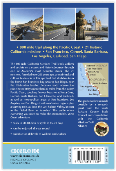
The California Mission Trails - Cicerone
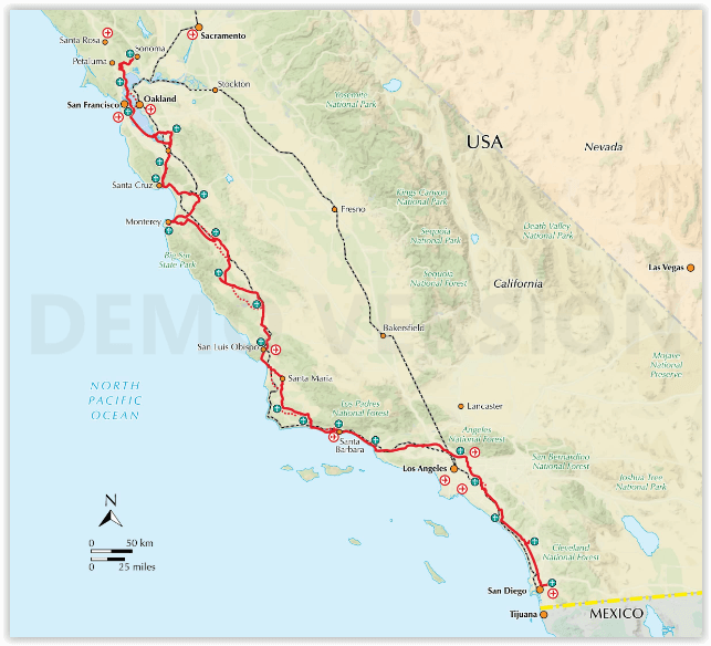
Productomschrijving: Gids over het wandelen en fietsen van de 1289 km lange California Missions Trail tussen San Francisco Bay en San Diego. De pelgrimsroute voert langs 21 historische Spaanse missies en kan worden voltooid in 50-60 wandeldagen of 2-3 weken fietsen. Met 1:100.000 kaarten, routebeschrijving en details van accommodatie en faciliteiten voor elke etappe.
Engelse omschrijving: Guidebook to walking and cycling the 800 mile (1289km) California Missions Trail between San Francisco Bay and San Diego. The pilgrimage trail takes in 21 historic Spanish missions and can be completed in 50-60 walking days or 2-3 weeks cycling. With 1:100,000 mapping, route description and details of accommodation and facilities for each stage.
Seasons:
California's moderate coastal weather allows virtually a 12-month season, with no freezing temperatures or snow on the route. Watch for high summer heat in inland valleys and fog near the coast.
Centres:
Metropolitan San Francisco, Los Angeles and San Diego; the seaside towns of Santa Cruz, Monterey, Carmel, Santa Barbara, Carlsbad and Solana Beach
Difficulty:
This route is suitable for all levels of walkers, with no special gear necessary. Cyclists can cover 95% of the route on conventional or electric-assist street bikes, but mountain bikes are advised for a few specific mountain paths.
Must See:
The trail visits 21 California missions, historic landmarks along this epic adventure that crosses the Golden Gate Bridge, traverses coastal mountain ranges, hugs the Pacific coast through charming beach towns like Santa Cruz, Santa Barbara and Carlsbad, and crosses vast farmlands in the Salinas Valley, the 'Salad Bowl of America'.
Artikelen uit dezelfde regio
Wandelgids Best Day Walks California - Lonely Planet • 9781838691172
Best Day Walks California - Lonely Planet Productomschrijving: Lonely Planet's Best Day Walks Californië is uw paspoort met 60 gemakkelijke wandel ontsnappingen in de natuur. Strek je benen weg van de stad door een wandeling te kiezen die bij je past, van een paar uur tot een hele dag, van gemakkelijk tot zwaar. Verken Yosemite National Park, bewonder de sequoia's en wandel door Gold Count…

Wandelkaart 252 Channel Islands National Park - Nat Geo • 9781566954105
Channel Islands National Park - Nat Geo Productomschrijving: De Channel Islands Nationaal Park, gelegen voor de kust van Californië, zijn de thuisbasis van vele unieke soorten flora en fauna. National Geographic's Trails Illustrated kaart van Channel Islands National Park bestrijkt met ongeëvenaard detail de vijf eilanden die het park omvat, inclusief The Nature Conservancy gebied van Sant…

Wandelkaart 804 Tahoe National Forest West - Nat Geo • 9781566954259
Tahoe National Forest West - Nat Geo Omvat: Donner Pass, Eldorado National Forest, Granite Chief Wilderness, Mosquito Ridge, Plumas National Forest, Sawtooth Ridge, Tahoe National Forest, Truckee. Engelse omschrijving: Expertly researched and created in partnership with the U.S. Forest Service and others, National Geographic's Trails Illustrated map of Yuba and American Rivers region o…

Reisgids San Francisco - Gallimard • 9782742453474
Reisgids San Francisco - Gallimard Productomschrijving: Van Chinatown tot de Golden Gate Bridge, van Mission tot Twin Peakes, van SFMoMa tot het Asian Art Museum, van Potrero tot Haight-Ashbury, San Francisco ontvouwt zich in een oogwenk met een gids als geen ander. Franse omschrijving: De Chinatown au Golden Gate Bridge, de Mission à Twin Peakes, du SFMoMa à l'Asian Art Museum, …

Reisgids Wat & hoe Californië - Kosmos • 9789043934503
Reisgids Californië - Kosmos Productomschrijving: Uitgebreide verkenning van de iconische steden van Californië: Los Angeles, San Francisco en San Diego. Ontdek de bruisende cultuur van LA, van Hollywood tot de stranden van Santa Monica. In San Francisco bewonder je de beroemde Golden Gate Bridge, de historische wijk Fisherman's Wharf en de karakteristieke kabeltrams. San Diego biedt e…