
Wandelkaart 252 Channel Islands National Park - Nat Geo
Deze eilanden zijn gelegen voor de kust van Californië
Korte omschrijving
Channel Islands National Park - Nat Geo Productomschrijving: De Channel Islands Nationaal Park, gelegen voor de kust van Californië, zijn de thuisbasis van vele unieke soorten flora en fauna...

Specificaties
- Uitgever: National Geographic
- ISBN-13: 9781566954105
- HOOFDCATEGORIEËN: Wandelkaart
- Activiteiten: Wandelen, Hiking & Trekking
- Regio: Californië, USA
- Land: Verenigde Staten van Amerika (USA)
- Nationale parken: Channel Islands NP, California USA
- Schaal: 1:50000
- Afmeting: 11x24
- Taal: Engels
Volledige omschrijving
Channel Islands National Park - Nat Geo
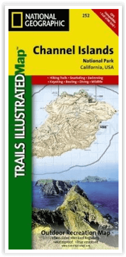
Productomschrijving: De Channel Islands Nationaal Park, gelegen voor de kust van Californië, zijn de thuisbasis van vele unieke soorten flora en fauna. National Geographic's Trails Illustrated kaart van Channel Islands National Park bestrijkt met ongeëvenaard detail de vijf eilanden die het park omvat, inclusief The Nature Conservancy gebied van Santa Cruz Island en de vele State Marine Reserve Areas rondom de eilanden. Deskundig onderzocht en gemaakt in samenwerking met de National Park Service en anderen, geeft de kaart achtergrondinformatie van het park en van elk afzonderlijk eiland, samen met de voorschriften en richtlijnen. Daarnaast wordt informatie gegeven over het vervoer naar de eilanden en worden waarschuwingen gegeven voor de veiligheid op het land (wandelen), in het water (zwemmen, snorkelen en duiken) en bij het varen (en kajakken).
Engelse omschrijving: Located just off the California shore, the Channel Islands are home to many unique species of flora and fauna. National Geographic's Trails Illustrated map of Channel Islands National Park covers with unparalleled detail the five islands that encompass the park, including The Nature Conservancy area of Santa Cruz Island and the many State Marine Reserve Areas surrounding the islands. Expertly researched and created in partnership with the National Park Service and others, the map provides background information of the park and of each individual island along with its regulations and guidelines. In addition, information regarding transportation to the islands is given as well as land (hiking), water (swimming, snorkeling and diving) and boating (and kayaking) safety warnings.
Each island is shown with a trail guide, listing trail start and destination points, distances and difficulty. Trails are mapped with mileage markers and coded according to trail type. Island roads, which can also be used use for hiking, are shown as well. An inset map of the Scorpion Area provides extra detail of this popular area. The map includes contour lines, elevations, labeled peaks, selected waypoints, water features and areas of wooded cover. Moreover, many recreation features and facilities are pinpointed, such as ranger stations, campgrounds, restroom, picnic areas and historic buildings.
Every Trails Illustrated map is printed on "Backcountry Tough" waterproof, tear-resistant paper. A full UTM grid is printed on the map to aid with GPS navigation.
Other features found on this map include: Anacapa Passage, Channel Islands National Park, Encino Reservoir, Franklin Canyon Reservoir, Laguna Point, Point Dume, San Fernando Valley, San Miguel Island, San Miguel Passage, Santa Barbara Island, Santa Cruz Channel, Santa Cruz Island, Santa Monica Mountains, Santa Rosa Island, Sepulveda Dam, Stone Canyon Reservoir.
Locatie op kaart
Artikelen uit dezelfde regio

Reisgids California - Lonely Planet • 9781838691813
Reisgids California - Lonely Planet Productomschrijving: Van mistige Noord-Californische sequoiawouden tot zonovergoten Zuid-Californische stranden, in de betoverende Golden State lijkt Disneyland heel gewoon. Lonely Planet brengt je naar het hart van Californië, met geweldige reiservaringen en het beste planningsadvies. Lonely Planet California is je paspoort voor het meest relevante,…

Reisgids Californie 2024-25 - Le Routard • 9782017888208
Reisgids Californie - Hahette Productomschrijving: De nieuwe update van Le Routard, Frankrijks nummer 1 reisgids! De legendarische westkust, bakermat van film, surfen en technologie. Tussen de Stille Oceaan, de bergen, de wijngaarden en de woestijn maak je een onvergetelijke roadtrip van San Francisco naar Los Angeles langs de grote nationale parken. Franse omschrijving: Nouvelle…

Wandelgids California & Southwest USA's NP's - Lonely Planet • 9781838696061
Wandelgids California & Southwest USA's National Parks Productomschrijving: Lonely Planet's California and Southwest USA's National Parks is uw paspoort voor het meest actuele advies over wat je moet zien en overslaan. Wandel door de Grand Canyon, bewonder Sequoia en jaag op watervallen in Yosemite; allemaal met je vertrouwde reisgenoot. Duik in het hart van de nationale parken van Califor…

Reisgids San Diego - Top 10 - DK Eyewitness • 9780241367964
DK Eyewitness TOP 10 - San Diego California Omvat: Downtown, Old Town, Uptown, Mission Valley, Ocean Beach & Coronado. Productomschrijving: Verken de prachtige tuinen van Balboa Park, bezoek de beroemde San Diego Zoo, wandel langs de Embarcadero naar het historische tallship Star of India, of geniet van het nautische erfgoed van de stad in het Maritiem Museum. Van de Top 10 tuinen en n…

Reisgids California wine country USA - Top 10 - Eyewitness • 9781409326823
California wine country USA - Top 10 - Eyewitness Productomschrijving: Explore California's world-class wineries, take a leisurely tour on the Napa Valley Wine Train, cycle along the Silverado Trail or venture to the Russian River for the renowned River Jazz and Blues Festival. From Top 10 festivals to the Top 10 beaches - discover the best of California Wine Country with this easy-to-use …