
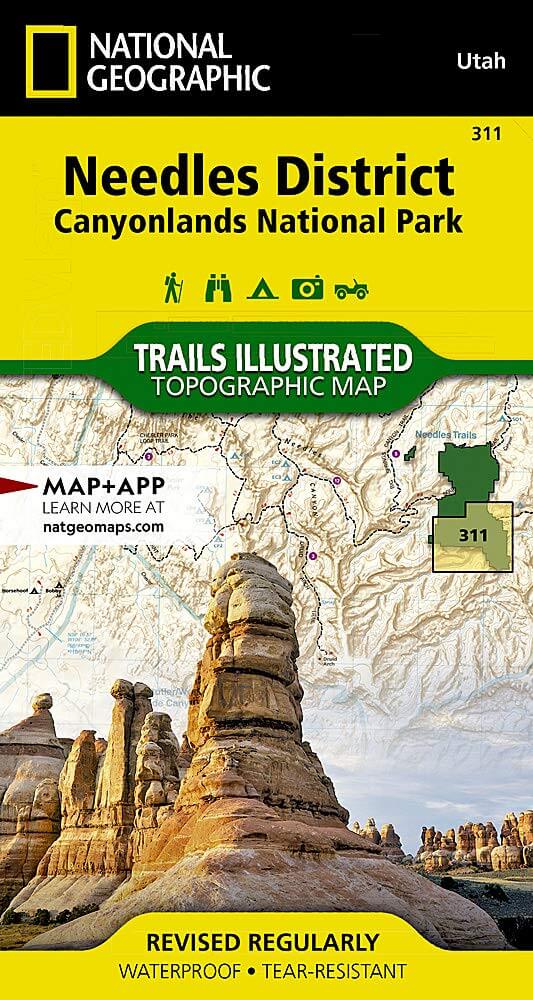
Wandelkaart 311 Canyonlands NP - Needles District - Natgeo
Gelegen in het Zuidoosten van Utah- dichtbij de stad Moab
Korte omschrijving
TOPO Wandelkaart 311 - Canyonlands NP - Needles District Productomschrijving: Canyonlands National Park is een Amerikaans nationaal park gelegen in het Zuidoosten van Utah, dichtbij de stad ...

Specificaties
- Uitgever: National Geographic
- ISBN-13: 9781566954617
- HOOFDCATEGORIEËN: Wandelkaart
- Regio: Utah, USA
- Land: Verenigde Staten van Amerika (USA)
- Nationale parken: Canyonlands NP, Utah USA
- Schaal: 1:35000
- Afmeting: 10x19
- Taal: Engels
Volledige omschrijving
TOPO Wandelkaart 311 - Canyonlands NP - Needles District
Productomschrijving: Canyonlands National Park is een Amerikaans nationaal park gelegen in het Zuidoosten van Utah, dichtbij de stad Moab. Het park omvat een kleurrijk landschap, geerodeerd in verschillende canyons door het water van de Colorado River. Het park is verdeeld in 4 districten: the Island in the Sky District, the Needles district, the Maze district, en the combined rivers—the Green & Colorado rivieren
Algemene kaart : 9781566953269
The Island in the Sky District - 9781566954600
Needles district - 9781566954617
Maze district - 9781566954624
Locatie op kaart
Gekoppelde artikelen

Wandelkaart 210 Canyonlands NP - Utah - Natgeo • 9781566953269
standaard versieTOPO Wandelkaart 210 - Canyonlands NP - Utah - Nat geo Productomschrijving: Canyonlands National Park is een Amerikaans nationaal park gelegen in het Zuidoosten van Utah, dichtbij de stad Moab. Het park omvat een kleurrijk landschap, geerodeerd in verschillende canyons door het water van de Colorado River. The park is verdeeld in 4 districten: the Island in the Sky District, the Needles d…

Wandelkaart 310 Canyonlands NP - Island in the Sky District • 9781566954600
standaard versieTOPO Wandelkaart 310 -Canyonlands NP - Island in the Sky District Productomschrijving: Canyonlands National Park is een Amerikaans nationaal park gelegen in het Zuidoosten van Utah, dichtbij de stad Moab. Het park omvat een kleurrijk landschap, geerodeerd in verschillende canyons door het water van de Colorado River. Het park is verdeeld in 4 districten: the Island in the Sky District, the…

Wandelkaart 312 Canyonlands NP - Maze District - Natgeo • 9781566954624
standaard versieTopografische Wandelkaart 312 - Canyonlands NP - Natgeo Productomschrijving: Canyonlands National Park is een Amerikaans nationaal park gelegen in het Zuidoosten van Utah, dichtbij de stad Moab. Het park omvat een kleurrijk landschap, geerodeerd in verschillende canyons door het water van de Colorado River. Het park is verdeeld in 4 districten: the Island in the Sky District, the Needles …
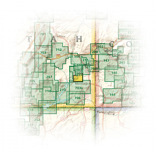
Overzichtskaarten

NAT GEO Utah trail maps
NAT GEO Utah trail maps

Producten op de overzichtskaart
Klik op een product om naar de detailpagina te gaan.
- Wandelkaart 210 Canyonlands NP - Utah - Natgeo
- Wandelkaart 211 Arches National Park- Utah - Natgeo
- Wandelkaart 214 Zion National Park - Natgeo
- Wandelkaart 219 Bryce Canyon NP Utah - Natgeo
- Wandelkaart 220 Dinosaur National Monument - Natgeo
- Wandelkaart 267 Capitol Reef NP Utah - Natgeo
- Wandelkaart 310 Canyonlands NP - Island in the Sky District
- Wandelkaart 311 Canyonlands NP - Needles District - Natgeo
- Wandelkaart 312 Canyonlands NP - Maze District - Natgeo
- Wandelkaart 702 Cedar Mountain - Utah USA - Nat Geo
- Wandelkaart 703 Manti-La Sal National forest - Natgeo
- Wandelkaart 704 Flaming Gorge- Recreational Area - Utah
- Wandelkaart 705 Mount Dutton & Aquarius Plateau - Nat Geo
- Wandelkaart 213 Glen Canyon & Capitol Reef NP - Nat Geo
NAT GEO Utah trail maps
NAT GEO Utah trail maps
Producten op de overzichtskaart
Klik op een product om naar de detailpagina te gaan.
- Wandelkaart 210 Canyonlands NP - Utah - Natgeo
- Wandelkaart 211 Arches National Park- Utah - Natgeo
- Wandelkaart 214 Zion National Park - Natgeo
- Wandelkaart 219 Bryce Canyon NP Utah - Natgeo
- Wandelkaart 220 Dinosaur National Monument - Natgeo
- Wandelkaart 267 Capitol Reef NP Utah - Natgeo
- Wandelkaart 310 Canyonlands NP - Island in the Sky District
- Wandelkaart 311 Canyonlands NP - Needles District - Natgeo
- Wandelkaart 312 Canyonlands NP - Maze District - Natgeo
- Wandelkaart 703 Manti-La Sal National forest - Natgeo
- Wandelkaart 704 Flaming Gorge- Recreational Area - Utah
- Wandelkaart 709 Wasatch Front North Utah - Nat Geo
- Wandelkaart 710 Canyons of the Escalante NP - Nat Geo
- Wandelkaart 213 Glen Canyon & Capitol Reef NP - Nat Geo
Artikelen uit dezelfde regio

Wandelkaart 219 Bryce Canyon NP Utah - Natgeo • 9781566953207
TOPO Wandelkaart 219 - Bryce Canyon NP Utah - Natgeo Productomschrijving: Bryce Canyon Nationaal Park is een Amerikaans nationaal park gelegen in het zuidwesten van Utah. De hoofd atractie in het park is Bryce Canyon, die ondanks zijn naam, geen echte canyon is, maar een collectie van lange natuurlijke amphitheaters langs de oostelijke zijde van het Paunsaugunt Plateau. Engelse omschri…

Wandelkaart 507 Moab Oost - Dewey Bridge & Sand Flats - Nat Geo • 9781566959025
Wandelkaart Moab Oost - Dewey Bridge & Sand Flats - Nat Geo Productomschrijving: Deze kaart omvat het Oostelijke gedeelte van het grote Moab recreatie gebied van het befamde National Geographic's Trails Illustrated. De kaart biedt een overzicht genummerd 507 op onderstaande kaart van het gebied. Het gebied omvat 3 kaarten met nummers, 505, 506 & 507. De 505 is de kaart die alles in één kee…

Reisgids Zuidwest Amerika - Insight Guides • 9789066554801
Zuidwest Amerika - Insight Guides Productomschrijving: Zuidwest-Amerika is een fenomenaal mooi gebied dat zich uitstrekt over verschillende staten. Dit boek voert u mee door Arizona, New Mexico, Zuid-Utah en delen van Colorade, Texas en Nevada, inclusief Las Vegas. De auteurs en fotografen laten u op de bekende, onovertroffen en veelvuldig bekroonde Insight Guide -wijze in woord en bee…

Wandelkaart 506 Moab West - Klondike Bluffs & Dead Horse Point • 9781566959018
Wandelkaart Moab West - Klondike Bluffs & Dead Horse Point Productomschrijving: Deze kaart omvat het westelijke gedeelte van het grote Moab recreatie gebied van het befamde National Geographic's Trails Illustrated. De kaart biedt een overzicht genummerd 506 op onderstaande kaart van het gebied. Het gebied omvat 3 kaarten met nummers, 505, 506 & 507. De 505 is de kaart die alles in één keer…

Reisgids USA Southwest & National Parks - DK Eyewitness • 9780241365519
USA Southwest & National Parks Omvat: Arizona, Las Vegas, Southern Utah, the Four Corners & New Mexico. Productomschrijving: Staar naar de diepten van de Grand Canyon, ervaar de glitter en glamour van de Las Vegas strip, beklim de rotsachtige overspanningen van Arches National Park of wandel door het historische Santa Fe: alles wat u moet weten is overzichtelijk weergegeven in kleurgec…