Wandelgids St Oswald's Way & Northumberland Coast Path - Cicerone
Heavenfield- Northumberland NP- Simonside Hills- Coquet Valley...
Korte omschrijving
St Oswald's Way & Northumberland Coast Path - Cicerone Productomschrijving: Deze gids beschrijft de St Oswald's Way en Northumberland Coast Paths, beide langeafstandswandelpaden door Northum...

Specificaties
- Uitgever: CICERONE Press
- ISBN-13: 9781786311559
- HOOFDCATEGORIEËN: Wandelgids
- Activiteiten: Wandelen, Hiking & Trekking
- Auteur: Rudolf Abraham
- Regio: Northumberland, Engeland
- Land: England
- Lange afstand wandelroutes: Northumberland Coastal Path (42 km), St Oswald's Way (156 km)
- Nationale parken: Northumberland NP, England
- AONB - Area of Outstanding Beauty: Northumberland coast AONB
- Blz.: 144
- Afmeting: 12x17
- Editie: 1
- Taal: Engels
Volledige omschrijving
St Oswald's Way & Northumberland Coast Path - Cicerone
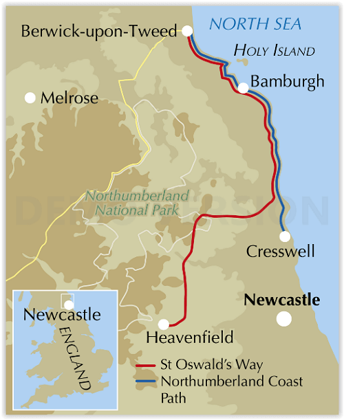
Productomschrijving: Deze gids beschrijft de St Oswald's Way en Northumberland Coast Paths, beide langeafstandswandelpaden door Northumberland. St Oswald's Way (156 km, 97 mijl) begint in Heavenfield en doorkruist delen van het Northumberland National Park en bezoekt Hadrian's Wall, de Simonside Hills en de prachtige Coquet Valley, voordat het verder gaat langs de kust naar Lindisfarne (Holy Island).
Het Northumberland Coast Path (100 km, 62 mijl) loopt door het hele Northumberland Coast AONB met zijn adembenemende kustlandschap en vogelleven. Beide paden komen samen op Holy Island en het kustpad gaat verder naar Berwick-upon-Tweed. Elke route kan in een week worden gelopen.
De gids bevat praktisch advies over wanneer te gaan en wat mee te nemen, en informatie over de regio, het weer, wilde dieren, geschiedenis en erfgoed.
Engelse omschrijving: This guidebook describes the St Oswald's Way and Northumberland Coast Paths, both long-distance trails through Northumberland. St Oswald's Way (156 km, 97 miles) begins in Heavenfield and traverses parts of Northumberland National Park and visits Hadrian’s Wall, the Simonside Hills and the beautiful Coquet Valley, before continuing up the coast to Lindisfarne (Holy Island).
The Northumberland Coast Path (100km, 62 miles) takes in the whole of the Northumberland Coast AONB with its breathtaking coastal scenery and birdlife. Both trails converge on Holy Island, with the Coast Path continuing up to Berwick-upon-Tweed. Each trail can be walked in a week.
The guide includes practical advice on when to go and what to take, and information on the region, its weather, wildlife, history and heritage.

Locatie op kaart
Artikelen uit dezelfde regio

Wandelgids Hadrian's Wall Path - Trailblazer • 9781912716371
Hadrian's Wall Path 135 km - Trailblazer Productomschrijving: Hadrian's Wall Path is een lange-afstandwandelroute in het noorden van Engeland. De route loopt voor 135 km van Wallsend op de East coast van Engeland tot Bowness-on-Solway op de West kust. Voor het meeste van de route loopt het pad dicht bij Hadrian's Wall, die de defensieve muur omvat die gebouwd werd door de Romeinen op de no…

Wandelkaart 340 Holy Island & Bamburgh - OSI • 9780319475768
Wandelkaart Holy Island & Bamburgh - Explorer Active Productomschrijving: Holy Island en Bamburgh zijn 2 aan de kust liggende eilanden/archipel die de interesse trekt van velen in het teken van natuur bezoek, wandelen of fietsen. De locatie is zeer mooi wat de natuur betreft. Omvat: Cheswick, Ancroft, Haggerston, Bowsden, Beal, Fenwick, Holy Island, Holburn, Doddington, Belford, Waren …

Wandelkaart 340 Holy Island & Bamburgh - OSO • 9780319263907
Wandelkaart Holy Island & Bamburgh - OSI Productomschrijving: Holy Island en Bamburgh zijn 2 aan de kust liggende eilanden/archipel die de interesse trekt van velen in het teken van natuur bezoek, wandelen of fietsen. De locatie is zeer mooi wat de natuur betreft. Omvat: Cheswick, Ancroft, Haggerston, Bowsden, Beal, Fenwick; Holy Island, Holburn, Doddington, Belford, Waren Mill, Bambur…

Reisgids Go Slow Northumberland - Bradt Travel guides • 9781784776084
Reisgids Northumberland England - Bradt Productomschrijving: Deze nieuwe, grondig bijgewerkte tweede editie van Bradt's bestseller, uitgebreide gids voor Northumberland inclusief Newcastle, Hadrian's Wall & the Coast blijft de betrouwbare bron van informatie voor het ontdekken van het uiterste noordoosten van Engeland, een gebied dat Europa's grootste beschermde nachthemel herbergt - en En…

Wandelgids The Pennine Way - Trailblazer • 9781912716333
The Pennine Way 420 km - Trailblazer Productomschrijving: De Pennine Way, het bekendste nationale pad van Groot-Brittannië, slingert zich 420 km over woeste heidevelden en door stille dalen langs de ruggengraat van Noord-Engeland. Het begint in Edale in het Peak District en eindigt net over de grens in Schotland bij Kirk Yetholm. Dit prachtige wandelpad doorkruist 3 nationale parken - het …


