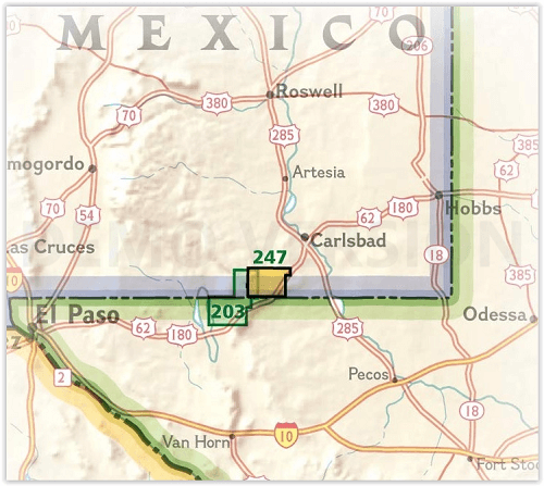
Wandelkaart 247 Carlsbad Caverns National Park - Nat Geo
Mudgetts WSA - Lincoln National Forest - Slaughter Canyon Cave
Korte omschrijving
Carlsbad Caverns National Park New Mexico - Nat Geo Productomschrijving: National Geographic's Trails Illustrated kaart van Carlsbad Caverns National Park is de meest uitgebreide kaart die b...

Specificaties
- Uitgever: National Geographic
- ISBN-13: 9781566954891
- Activiteiten: Wandelen, Hiking & Trekking
- Regio: New Mexico, USA
- Land: Verenigde Staten van Amerika (USA)
- Waterafstotende kaart: Nat Geo waterproof series
- Toepasselijke bergketen: Guadalupe Mountains, New Mexico USA
- Nationale parken: Carlsbad Caverns NP, New Mexico USA
- Regionale parken: Lincoln National Forest, New Mexico USA
- Schaal: 1:35000
- Afmeting: 11x24
- Taal: Engels
- Reeks: National Geographic Trails Illustrated
Volledige omschrijving
Carlsbad Caverns National Park New Mexico - Nat Geo
Productomschrijving: National Geographic's Trails Illustrated kaart van Carlsbad Caverns National Park is de meest uitgebreide kaart die beschikbaar is voor degenen die zowel boven als onder de grond op verkenning gaan in het prachtige deel van de Guadalupe Mountains in het zuidoosten van New Mexico. Deze unieke kaart is gemaakt in samenwerking met de National Park Service en de U.S. Forest Service en biedt informatie van onschatbare waarde over de overvloed aan recreatie- en avontuuractiviteiten in het gebied.
Eén kant van de kaart beslaat het hele nationale park, inclusief Carlsbad Wilderness, en aangrenzende gebieden, zoals het zuidoostelijke Lincoln National Forest en Mudgetts WSA. De andere kant van de kaart toont de ondergrondse werelden van Carlsbad Caverns en Slaughter Canyon Cave.
Beschrijvingen van paden in het park helpen je bij het kiezen van een geschikte route voor je avontuur. Navigeer met behulp van de hoogtelijnen op de kaart, hoogteverschillen, gelabelde pieken en toppen, waterpartijen, geselecteerde waypoints en het volledige wegennetwerk. Route-opties door de Caverns en Slaughter Canyon Cave worden getoond met gedetailleerde beschrijvingen. Ondergrondse kaarten hebben gelabelde kamers en stalactieten, stalagmieten, zuilen, hellingen, poelen, vleermuisguano, gips, onontdekte doorgangen en andere interessante punten. Ook inbegrepen zijn een reisoverzicht van het binnenland, veiligheidstips voor wandelaars, voorschriften voor grotten en achtergrondinformatie over het park met contactinformatie.
Engelse omschrijving: National Geographic's Trails Illustrated map of Carlsbad Caverns National Park is the most comprehensive map available for those exploring both above and below ground in the beautiful section of the Guadalupe Mountains in southeastern New Mexico. Created in cooperation with the National Park Service and U.S. Forest Service, this unique map provides invaluable information about the abundance of recreation and adventure activities in the area.
One side of the map covers the entire national park, including Carlsbad Wilderness, and adjacent areas, such as southeastern Lincoln National Forest and Mudgetts WSA. The other side of the map shows the underground worlds of Carlsbad Caverns and Slaughter Canyon Cave.
Descriptions of trails in the park will help you chose a suitable route for your adventure. Navigate using the map's contour lines, elevations, labeled peaks and summits, water features, selected waypoints and full road network. Route options through the Caverns and Slaughter Canyon Cave are shown with detailed descriptions. Underground maps have labeled rooms and pinpointed stalactites, stalagmites, columns, breakdowns, slopes, pools, bat guano, gypsum, unexplored passages and other points of interest. Also included are a backcountry travel overview, hiker safety tips, cavern regulations, and background information about the park with contact information.
Every Trails Illustrated map is printed on "Backcountry Tough" waterproof, tear-resistant paper. A full UTM grid is printed on the map to aid with GPS navigation.
Other features found on this map include: Carlsbad Caverns National Park, Lincoln National Forest.

Overzichtskaarten

NAT GEO New Mexico USA
NAT GEO New Mexico USA

Producten op de overzichtskaart
Klik op een product om naar de detailpagina te gaan.
Artikelen uit dezelfde regio

Wandelkaart 730 Taos Wheeler Peak - New Mexico - Nat Geo • 9781566953092
Taos Wheeler Peak - New Mexico - Nat Geo Omvat: Agua Fria Peak, Baldy Mountain, Carson National Forest, Cerro Vista, Eagle Nest Lake, Latir Peak Wilderness, Palo Flechado Pass, Wheeler Peak, Wheeler Peak Wilderness. Engelse omschrijving: The northern New Mexico town of Taos lies in the high desert bounded by the Sangre de Cristo Mountains. In those mountains northeast of the town, Whee…

Reisgids USA Southwest & National Parks - DK Eyewitness • 9780241365519
USA Southwest & National Parks Omvat: Arizona, Las Vegas, Southern Utah, the Four Corners & New Mexico. Productomschrijving: Staar naar de diepten van de Grand Canyon, ervaar de glitter en glamour van de Las Vegas strip, beklim de rotsachtige overspanningen van Arches National Park of wandel door het historische Santa Fe: alles wat u moet weten is overzichtelijk weergegeven in kleurgec…


