
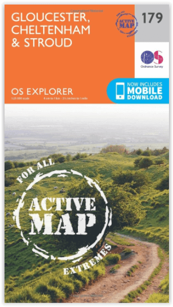
Wandelkaart 179 Gloucester Cheltenham & Stroud - OSI
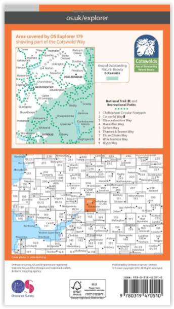
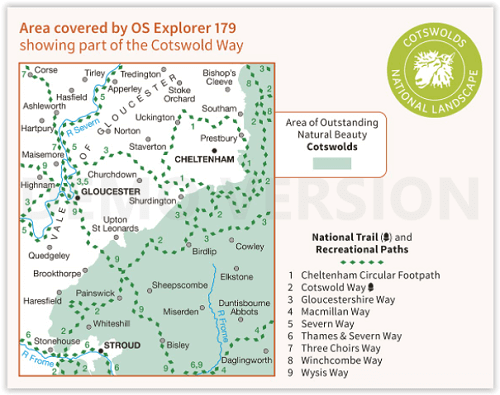
Cotswolds AONB- Vale van Gloucester & de Cotswolds way
Korte omschrijving
Wandelkaart Gloucester- Cheltenham & Stroud - S.W. England Productbeschrijving: Kaart nummer 179 in de OS Explorer reeks heeft betrekking op de omgeving van Gloucester, Cheltenham, Stroud. H...

Specificaties
- Uitgever: Ordnance Survey
- ISBN-13: 9780319470510
- HOOFDCATEGORIEËN: Wandelkaart
- Activiteiten: Wandelen, Hiking & Trekking
- Regio: Gloucestershire, Egland
- Land: England
- Waterafstotende kaart: Ordnance Survey ACTIVE Explorer Weatherproof Maps
- AONB - Area of Outstanding Beauty: Cotswolds AONB
- Schaal: 1:25000
- Afmeting: 13x24
- Taal: Engels
- Reeks: Explorer ACTIVE Series OSI
Volledige omschrijving
Wandelkaart Gloucester- Cheltenham & Stroud - S.W. England
Productbeschrijving: Kaart nummer 179 in de OS Explorer reeks heeft betrekking op de omgeving van Gloucester, Cheltenham, Stroud. Hoogtepunten van het gebied zijn onder andere: Cotswolds AONB gebied van uitzonderlijke natuurlijke schoonheid AONB, Vale van Gloucester, rivier de Severn en de Cotswolds way. De OS Explorer kaart voor Gloucester, Cheltenham & Stroud is beschikbaar in zowel de standaard papieren versie als de weerbestendige 'Actief' versie.
Productdiscription: Map sheet number 179 in the OS Explorer series covers the area around Gloucester, Cheltenham, Stroud. Highlights of the area include: Cotswolds Area of Outstanding Natural Beauty AONB, Vale of Gloucester, River Severn and the Cotswolds Way. The OS Explorer map for Gloucester, Cheltenham & Stroud is available in both the standard paper version and weatherproof 'Active' version.
Locatie op kaart
Gekoppelde artikelen

Wandelkaart 179 Gloucester Cheltenham & Stroud - OSI • 9780319243725
standaard versieWandelkaart Gloucester- Cheltenham & Stroud - Gloucestershire Productbeschrijving: Gloucester & Cheltenham 179 / Gloucester, Cheltenham & Stroud, Gloucestershire, England - Kaart nummer 179 in de OS Explorer reeks heeft betrekking op de omgeving van Gloucester, Cheltenham, Stroud. Hoogtepunten van het gebied zijn onder meer: The Cotswolds AONB gebied van uitzonderlijke natuurlijke scho…

Wandelkaart 179 Gloucester Cheltenham & Stroud - OSI • 9780319470510
weatherproof versieWandelkaart Gloucester- Cheltenham & Stroud - S.W. England Productbeschrijving: Kaart nummer 179 in de OS Explorer reeks heeft betrekking op de omgeving van Gloucester, Cheltenham, Stroud. Hoogtepunten van het gebied zijn onder andere: Cotswolds AONB gebied van uitzonderlijke natuurlijke schoonheid AONB, Vale van Gloucester, rivier de Severn en de Cotswolds way. De OS Explorer kaart voor G…
Overzichtskaarten

OSI Explorer & Explorer Active - Z.W. England Devon - Cornwall
OSI Explorer & Explorer Active - Z.W. England Devon - Cornwall

Producten op de overzichtskaart
Klik op een product om naar de detailpagina te gaan.
- Wandelkaart 102 Land's End - OSI
- Wandelkaart 102 Land's End - OSI
- Wandelkaart 103 The Lizard- Cornwall England - OSI
- Wandelkaart 103 The Lizard- Cornwall England - OSI
- Wandelkaart 104 Redruth & St Agnes- Cornwall - OSI
- Wandelkaart 104 Redruth & St Agnes- Cornwall - OSI
- Wandelkaart 105 Falmouth & Mevagissey - Cornawall - OSI
- Wandelkaart 105 Falmouth & Mevagissey - Cornawall - OSI
- Wandelkaart 106 Newquay & Padstow - Cornwall - OSI
- Wandelkaart 106 Newquay & Padstow- Cornwall - OSI
- Wandelkaart 107 St-Austell & Liskeard- Cornwall - OSI
- Wandelkaart 107 St-Austell & Liskeard & Fowey- Cornwall - OSI
- Wandelkaart 108 Lower Tamar Valley & Plymouth - OSI
- Wandelkaart 108 Lower Tamer Valley & Plymouth- Cornwall - OSI
- Wandelkaart 109 Bodmin Moor- Cornwal - OSI
- Wandelkaart 109 Bodmin Moor- Cornwal - OSI
- Wandelkaart 111 Bude- Boscastle & Tintagel- Devon - OSI
- Wandelkaart 111 Bude- Boscastle & Tintagel- Devon - OSI
- Wandelkaart 112 Launceston & Holsworthy- Devon - OSI
- Wandelkaart 112 Launceston & Holsworthy- Devon - OSI
- Wandelkaart 113 Okehampton- Devon England - OSI
- Wandelkaart 113 Okehampton- Devon England - OSI
- Wandelkaart 114 Exeter & Exe Valley- Devon - OSI
- Wandelkaart 114 Exeter & Exe Valley- Devon - OSI
- Wandelkaart 115 Exmouth & Sidmouth- Devon - OSI
- Wandelkaart 115 Exmouth & Sidmouth- Devon - OSI
- Wandelkaart 116 Lyme regis & Bridport- Devon - OSI
- Wandelkaart 116 Lyme Regis & Bridport- Dorset - OSI
- Wandelkaart 117 Cerne Abbas & Bere Regis - Dorset - OSI
- Wandelkaart 117 Cerne Abbas & Bere Regis - Dorset - OSI
- Wandelkaart OL15 Purbeck- South Dorset & Poole - OSI
- Wandelkaart 118 Shaftesbury & Cranbourne Chase - OSI
- Wandelkaart 118 Shaftesbury & Cranbourne Chase - OSI
- Wandelkaart 129 Yeovil & Sherborne- Somerset - OSI
- Wandelkaart 129 Yeovil & Sherborne- Somerset - OSI
- Wandelkaart 140 Quantock Hills AONB & Bridgwater- Devon - OSI
- Wandelkaart 140 Quantock Hills AONB- Somerset - OSI
- Wandelkaart 141 Cheddar Gorge & Mendip Hills - OSI
- Wandelkaart 141Shepton Mallet & Mendip Hills East - OSI
- Wandelkaart 142 Shepton Mallet & Mendip Hills - OSI
- Wandelkaart 142 Shepton Mallet & Mendip Hills - OSI
- Wandelkaart 143 Warminster & Trowbridge- Wiltshire - OSI
- Wandelkaart 143 Warminster & Trowbridge- Wiltshire - OSI
- Wandelkaart 130 Salisburry & Stonehenge- Wiltshire - OSI
- Wandelkaart 130 Salisburry & Stonehenge- Wiltshire - OSI
- Wandelkaart 131 Romsey- Andover & Test Valley- Hampshire
- Wandelkaart 131 Romsey & Andover - Hampshire - OSI
- Wandelkaart 153 Weston-super-Mare & Bleadon Hill - OSI
- Wandelkaart 153 Weston-Super-Mare & Bleadon Hill - OSI
- Wandelkaart 154 Bristol West & Portishead- Bristol - OSI
- Wandelkaart 154 Bristol West & Portishead- Bristol area
- Wandelkaart 155 Bristol & Bath Keynsham & Marshfield - OSI
- Wandelkaart 155 Bristol & Bath- Bristol Area - OSI
- Wandelkaart 156 Chippenham & Bradford-on-Avon - OSI
- Wandelkaart 156 Chippenham & Bradford-on-Avon- Wiltshire - OSI
- Wandelkaart 157 Marlborough & Savernake Forest - OSI
- Wandelkaart 157 Marlborough & Savernake Forest - OSI
- Wandelkaart 158 Newbury & Hungerford- Berkshire - OSI
- Wandelkaart 158 Newbury & Hungerford- West Berkshire - OSI
- Wandelkaart 167 Thornbury- Dursley & Yate - England- OSI
- Wandelkaart 167 Thornbury- Dursley & Yate - England- OSI
- Wandelkaart 168 Stroud- Tetbury & Malmesbury - OSI
- Wandelkaart 168 Stroud- Tetbury & Malmesbury - OSI
- Wandelkaart 169 Cirencester & Swindon - England - OSI
- Wandelkaart 169 Cirencester & Swindon - England - OSI
- Wandelkaart 170 Abingdon & Wantage - Oxfordshire - OSI
- Wandelkaart 170 Abingdon- Wantage & Vale - OSI
- Wandelkaart 179 Gloucester- Cheltenham & Stroud - OSI
- Wandelkaart 179 Gloucester- Cheltenham & Stroud - OSI
- Wandelkaart OL45 The Cotswolds AONB- Gloucestershire - OSI
- Wandelkaart 190 Malvern Hills AONB & Bredon Hill - OSI
- Wandelkaart 190 Malvern Hills AONB & Bredon Hill - OSI
- Wandelkaart 205 Stratford-upon-Avon & Evesham - OSI
- Wandelkaart 205 Stratford-upon-Avon & Evesham - OSI
- Wandelkaart 206 Edge Hill & Fenny Compton - OSI
- Wandelkaart 206 Edge Hill & Fenny Compton - OSI
Artikelen uit dezelfde regio

Wandelkaart 169 Cirencester & Swindon England - OSI • 9780319470411
Wandelkaart Cirencester & Swindon- Gloucestershire Omvat ook: Fairford & Cricklade. Productbeschrijving: Kaart nummer 169 in de OS Explorer kaarten reeks heeft betrekking op een gebied van Cirencester en Fairford met een gedeelte van de Cotswolds AONB in het noorden, tot de North Wessex Downs AONB in het zuiden. De nationale routes van Thames pad en Ridgeway vallen onder deze kaart, sa…

Wandelkaart 168 Stroud- Tetbury & Malmesbury - OSI • 9780319470404
Wandelkaart Stroud- Tetbury & Malmesbury - England Productbeschrijving: Kaart nummer 168 in de OS Explorer kaarten reeks omvat Stroud, Tetbury, Malmesbury en Nailsworth. Hoogtepunten van het gebied zijn onder meer: Cotswolds AONB, Cotswold Way, Monarch Way en de Thames Path. De OS Explorer kaart voor Stroud, Tetbury & Malmesbury is beschikbaar in zowel de standaard papieren versie als de w…

Wandelgids 50 walks in Gloucestershire - AA Publishing • 9780749583729
50 walks in Gloucestershire - AA Publishing Productomschrijving: Gloucestershire, gelegen in het schilderachtige hart van Engeland, biedt een rijke verscheidenheid aan wandelroutes die zowel natuurliefhebbers als geschiedenisfanaten aanspreken. Met 50 wandelingen verspreid door de glooiende heuvels van de Cotswolds, diepe bossen van het Forest of Dean en langs historische bezienswaardighed…

Wandelgids & Fietsgids The Cotswold AONB - Cicerone • 9781852847067
Wandelgids & Fietsgids - The Cotswold AONB - Cicerone Productomschrijving: De Cotswolds is de thuisbasis van mooie honing-hued stenen dorpen in een glooiende landschap. De dramatische 100-mijl lange kalkstenen helling biedt een adembenemend uitzicht, terwijl het netwerk van rustige wegen, fietsvriendelijke kanaalwegen, sporen en ruiterpaden perfect is voor verkenning op een fiets. De Cotwo…

Wandelgids Walking the Thames Path National Trail - Cicerone • 9781786311481
Thames Path National Trail - Cicerone Productomschrijving: Een gloednieuwe wandelgids vover het Theemspad, een National Trail van 180 mijl tussen de Thames Barrier in Londen en de bron van de rivier in Gloucestershire, door Windsor, Oxford en het platteland. Biedt volledige informatie over deze gemakkelijke route langs de rivier die ongeveer twee weken in beslag neemt. Inclusief een 1:25K …