
Wandelgids The West Highland Way - Rucksack Readers
Milngavie nabij Glasgow tot Fort William door de Schotse Hoogland


Korte omschrijving
The West Highland Way - Rucksack Readers Productomschrijving: Een unieke intussen zeer gekende wandelroute, die loopt van Milngavie nabij Glasgow tot Fort William door de Schotse Hooglanden....

Specificaties
- Uitgever: RUCKSACK READERS
- ISBN-13: 9781913817213
- HOOFDCATEGORIEËN: Wandelgids
- Activiteiten: Wandelen, Hiking & Trekking
- Auteur: Jacquetta Megarry
- Regio: Highlands, Schotland, Schotland
- Land: Schotland
- Lange afstand wandelroutes: West Highland Way, Schotland (152 km)
- Blz.: 80
- Schaal: 1:40000
- Afmeting: 13x22
- Editie: 6
- Taal: Engels
Volledige omschrijving
The West Highland Way - Rucksack Readers
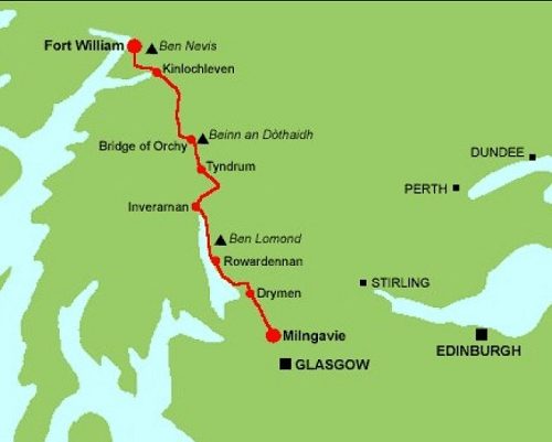
Productomschrijving: Een unieke intussen zeer gekende wandelroute, die loopt van Milngavie nabij Glasgow tot Fort William door de Schotse Hooglanden. De Route is 152 km Lang en brengt u door de westelijke Highlands van Schotland starten vanuit Glasgow.
Engelse omschrijving: The West Highland Way is the first, and remains the most famous, of Scotland’s Great Trails, running for 96 miles (152 km) through superb scenery. Starting from the outskirts of Glasgow, it passes through Scotland’s first National Park, along the shores of beautiful Loch Lomond, across the wilds of Rannoch Moor and ends in Fort William at the foot of Ben Nevis, Britain’s highest mountain.
This sixth edition of our popular rucksack-friendly guidebook has been revised for 2024 with various updates. It has more pages, fresh photos and mapping at 1:42,500 on 15 pages, yet thanks to robust perfect binding (glued and sewn) it’s lightweight, pocketable and rainproof.
This guidebook contains all you need to plan and enjoy the West Highland Way:
• the Way in sections, with summaries of distance, terrain and altitude profiles
• where to find food and drink, accommodation and how to split the distance
• concise background on the history, heritage and wildlife
• information about side-trips, e.g. Ben Lomond and Ben Nevis
• background information about Loch Lomond, history, habitats and wildlife
• planning information for travel by car, train, bus or plane
• 15 pages with detailed route mapping at 1:42,500
• in full colour, with 120 photographs
• rucksack-friendly and on rainproof paper.
Locatie op kaart
Artikelen uit dezelfde regio

Reisgids Handbook Schotland Highlands & Islands - Footprint • 9781911082576
Reisgids Handbook Schotland/Scotland Highlands & Islands - Footprint Productomschrijving: Als de regen ophoudt met vallen en de mist opklaart, is er geen mooiere plek op aarde dan de Schotse Hooglanden en Eilanden. Footprint's Schotland Highlands & Islands geeft je alles wat je nodig hebt om het meeste uit Europa's laatste grote wildernis te halen: de mooiste glens en lochs, de spookachtig…

Wandelkaart 431Glen Urquhart & Strathglass - OSI • 9780319246634
Wandelkaart Glen Urquhart & Strathglass - Highlands Schotland Productbeschrijving: Drumnadrochit & Muir of Ord. 431 / Glen Urquhart & Strathglass, Highlands, Schotland - Ten westen van de Highalnd hoofdstad Inverness, omvat deze OS Explorer kaart 431 Drumnadrochit north to Muir of Ord. Het omvat de nationale Scenic gebied van Strathfarrar, Orrin Reservoir, en een kleine hoeveelheid va…

Wandelgids Ben Nevis & Glen Coe Schotland - Cicerone • 9781852848712
Wandelgids - Ben Nevis & Glen Coe Schotland - Cicerone Productomschrijving: Wandelgids voor de regio van Schotland, de Ben Nevis en Glen Coe, en omvat 100 ingedeelde routes van tussen de 2 tot en met 26km. De routes variëren van zachte wandelingen tot Bothy treks en omvatten 43 Munro's en 3 scrambles. De routes omvatten wandelingen in de buurt van Kinlochleven, Fort William, de Grey Corrie…

Wandelkaart 33 Loch Alsh Glen Shiel & Loch Hourn - OSI • 9780319261316
Wandelkaart Loch Alsh- Glen Shiel & Loch Hourn - Schotland Productbeschrijving: OS Landranger kaart 33 toont de noordoostelijke kust van Schotland aan, de gebieden rond Glen Shiel en Glenkingie, evenals Loch Duich, Hourn Loch, Loch Alsh, Loch Nevis en Loch Quoich. Als u op zoek bent een plek om er vanuit te geraken, zou dit wel eens de plaats kunnen zijn. De OS Landranger kaarten reek…

Wandelkaart Great Glen Way - Schotland - Harvey maps • 9781851374632
Wandelkaart Great Glen Way - Schotland - Harvey maps Productomschrijving: Toont de gehele route op één vel. 117km (73 mijl) van Fort William tot Inverness via Fort Augustus langs het Caledonisch Kanaal en de noordelijke oever van Loch Ness. Informatie over het vinden van accommodatie, camping, voedsel. Routebeschrijving naar het start van de route. Nieuwe generatie HARVEY Superwalker,…