
Wandelgids The Two Moors Way - Cicerone
Two Moors Way beslaat 153 km van Ivybridge naar Lynmouth
Korte omschrijving
Wandelgids, The Two Moors Way (9781852849917) Cicerone Press Productomschrijving: De oorspronkelijke Two Moors Way beslaat 153 km van Ivybridge aan de zuidelijke grens van Dartmoor National ...

Specificaties
- Uitgever: CICERONE Press
- ISBN-13: 9781852849917
- HOOFDCATEGORIEËN: Wandelgids
- Activiteiten: Wandelen, Hiking & Trekking
- Auteur: Sue Viccars
- Regio: Devon, England
- Land: England
- Lange afstand wandelroutes: The Two Moors Way, England (153 km)
- Nationale parken: Dartmoor NP, Devon England, Exmoor NP, Devon England
- Blz.: 216
- Afmeting: 12x17
- Editie: 2
- Taal: Engels
Volledige omschrijving
Wandelgids, The Two Moors Way (9781852849917) Cicerone Press
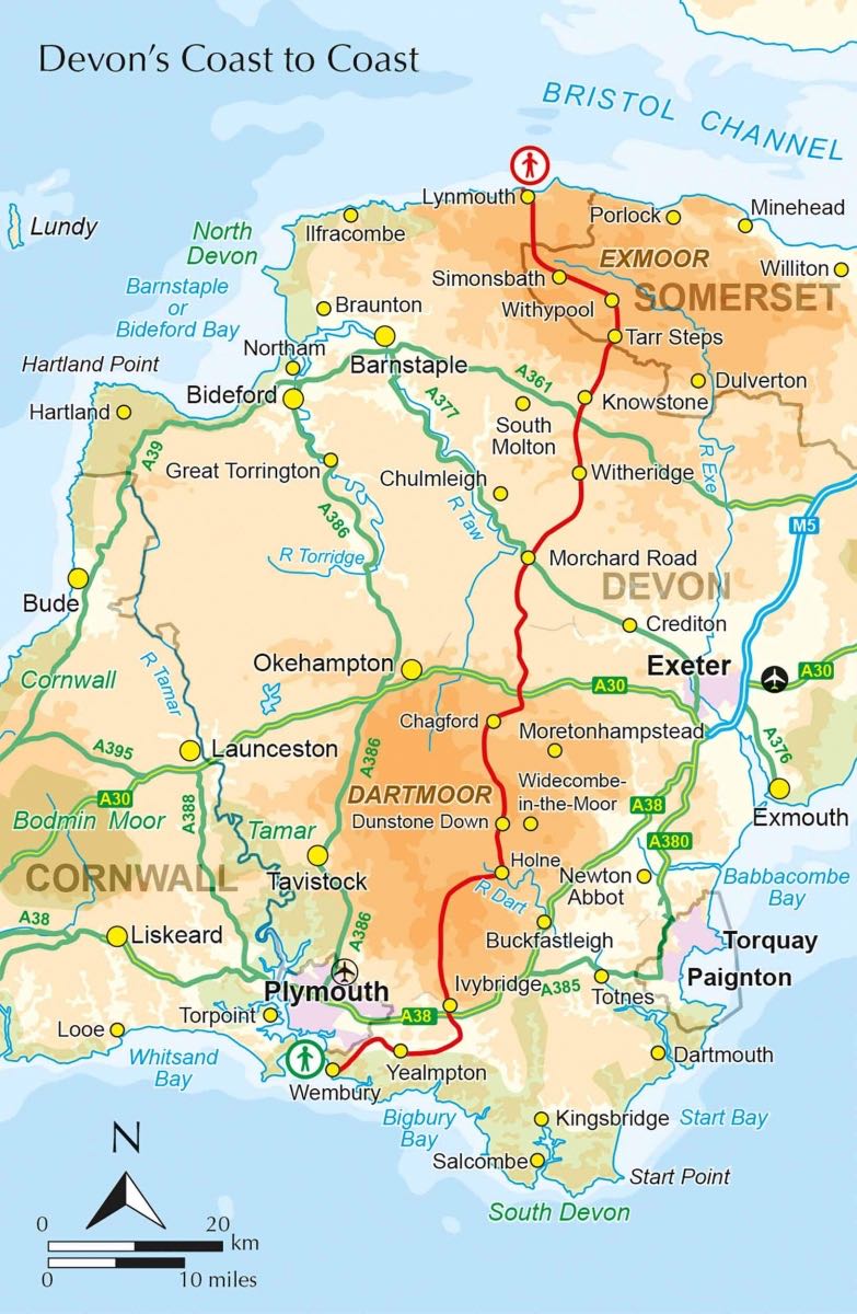
Productomschrijving: De oorspronkelijke Two Moors Way beslaat 153 km van Ivybridge aan de zuidelijke grens van Dartmoor National Park naar Lynmouth aan de kust van Noord-Devon in Exmoor National Park. Als u een Coast to Coast-wandeling wilt maken, kunt u beginnen bij Wembury aan de kust van Zuid-Devon en de Erme-Plym-route volgen naar Ivybridge, waarbij u ongeveer 15 mijl toevoegt.
Product description: This guidebook to walking Coast to Coast across Devon, presents a 117 mile route incorporating the Two Moors Way and a section of the Erme-Plym Trail. Beginning at Wembury Bay on the south coast and finishing at Lynmouth, the 11-stage walk passes through the beautiful Devon countryside and across two of southwest England’s magnificent moorlands, Dartmoor and Exmoor. The schedule can be adjusted to give a one-week walk, or a more leisurely pace if preferred, and the book includes low-level bad-weather alternative routes for some moorland stretches.
A full route description is given for walking the route from south to north, with a summary description for walking in the opposite direction. 1:50,000 map extracts show the route and there is lots of practical information on public transport, refreshments and accommodation to make day-by-day planning simple. A map booklet showing the full route on OS 1:25K maps is included with this guide. The county of Devon incorporates a wonderful range of landscapes, from the rolling fields of South Devon and the narrow-hedged lanes of Mid Devon to the wild, wide-open spaces of Dartmoor, home to hill ponies, granite tors and Bronze Age relics. To the north, Exmoor’s sandstone moorland sweeps down to the sea, and lofty coastal hills tower over the Bristol Channel
Locatie op kaart
Artikelen uit dezelfde regio

Wandelkaart XT40 Ultra - Dartmoor NP Noord - Harvey Maps • 9781851376322
Wandelkaart XT40 Ultra - Dartmoor NP Noord - Harvey Maps Productomschrijving: Omvat een groot gebied, maar de kaart is wel zeer praktisch en compact en in zakformaat - De kaart omvat gedetailleerde informatie voor lopers en wandelaars van het noordelijk deel van Dartmoor National Park. Omvat eveneens Dartmoor's bekende Tors waaronder Haytor Rocks, Yes Tor & High Willhays. Archaeologisc…

Fietskaart Dartmoor - South Devon - Goldeneye • 9781859652473
Fietskaart Dartmoor South Devon - Goldeneye Productomschrijving: Een gloednieuwe overzichtskaarten van het bewonderenswaardige nationale park van Devon in England, namelijk Dartmoor NP. De kaart omvat 18 cirkelvormige fietsroutes in het park, als ook 27 nationale fietsroutes. •18 circular routes overprinted on map •National Cycle Network routes 27 (Coast to Coast) 2 (Southern Coasta…

Wandelgids Walking the Jurassic Coast - Cicerone • 9781852847418
Wandelgids - Walking the Jurassic Coast - Cicerone Discover the Jurassic Coast of Devon and Dorset with a Cicerone guide. Productomschrijving: Deze gids bevat 30 wandelingen naar de Jurassic Coast van Devon en Dorset. Dekking van de kust tussen Exmouth en Bournemouth, deze prachtige routes variëren van 3 tot 16 mijl (5 tot 24km). De gids verkent en geeft uitleg over de spectaculaire ge…

Wandelkaart 126 Clovelly & Hartland- Devon England - OSI • 9780319470015
Wandelkaart Clovelly & Hartland - Devon England - OSI Productbeschrijving: Kaart nummer 126 in de OS Explorer reeks omvat Clovelly, Bideford, Hartland, Bradworthy en great Torrington. Hoogtepunten van het gebied zijn onder andere: Noord-Devon en Cornwall AONB, rivier Torridge en Tamar, Hartland punt, Barnstaple en Bideford Bay en Coombe. Ook omvat een deel van de South West Coast Path. De …

Wandelkaart Dartmoor National Park - Harvey maps • 9781851374649
Wandelkaart Dartmoor National Park - Harvey maps Productomschrijving: Deze Harvey kaart heeft de gehele Dartmoor op één kaart en wordt afgedrukt in samenwerking met de British Council van het alpinisme. Het omvat ook een geologische kaart van het gebied speciaal ontworpen door de British Geological Survey, klimcrags zijn ook gemarkeerd op de kaart. De kaart heeft ook tips over het gebruik …