
Wandelgids The Pilgrim's Way - Cicerone
Alle gegevens van deze uitermate gekende route
Korte omschrijving
Wandelgids - The Pilgrim's Way - Cicerone Productomschrijving: Een samenstelling van alle route gegevens van deze uitermate gekende St-jacobs/bedevaart wandelroute in hartje Engeland. ...

Specificaties
- Uitgever: CICERONE Press
- ISBN-13: 9781852847777
- HOOFDCATEGORIEËN: Wandelgids
- Activiteiten: Wandelen, Hiking & Trekking
- Auteur: Leigh Hatts
- Regio: South & South East England
- Land: England
- Lange afstand wandelroutes: The Pilgrim's Way, London England (150 km)
- Bedevaart routes: The Pilgrims' Way
- Blz.: 208
- Afmeting: 12x17
- Editie: 1
- Taal: Engels
Volledige omschrijving
Wandelgids - The Pilgrim's Way - Cicerone
Productomschrijving: Een samenstelling van alle route gegevens van deze uitermate gekende St-jacobs/bedevaart wandelroute in hartje Engeland.
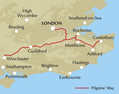
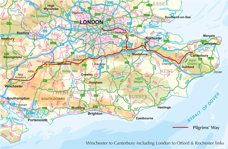
Product description: This guidebook details the Pilgrims' Way, an historic pilgrimage route to Canterbury Cathedral in Kent, home of the shrine of the martyred archbishop, St Thomas Becket. The route is described both from Winchester in Hampshire (136½ miles) and London's Southwark Cathedral (90¼ miles), with an optional spur to Rochester Cathedral.
With relatively easy walking on ancient byways, the route from Winchester is presented in 15 stages of 4¾-13½ miles: it can be comfortably completed in under a fortnight. It follows a major chalk ridge through scenic countryside, taking in characterful towns and villages and historic churches. The route from Southwark is described in 10 stages and includes a visit to the ruined Lesnes Abbey.
Seasons:
Medieval pilgrims were hardy and often undertook the walk in winter but summer and autumn offer the chance of seeing hops, hillside vineyards, lavender fields and orchards bursting with growth.
Centres:
Winchester, Alton, Farnham, Guildford, London, Dartford and Rochester, with plenty of accommodation and easy transport on the two routes.
Difficulty:
The first pilgrims always sought the easiest route so while there are unavoidable rises in ground and sometimes steep hills there are also long flat stretches. No special equipment is required beyond a water bottle and sandwiches in case progress is slower than expected. The ancient rutted path can be partly flooded in wet winter months.
Must See:
The Pilgrims' Way is often along a shelf on the side rather than the top of the North Downs but still high enough for long views. The downs are broken by valleys marked by chapels, castles and river crossings.
.png)
Locatie op kaart
Overzichtskaarten

Alle Bedevaart routes in ons gamma
Alle Bedevaart routes in ons gamma

Producten op de overzichtskaart
Klik op een product om naar de detailpagina te gaan.
- Wandelgids - GR655 - Bruxelles-Paris-Tours - FFR
- Via Francigena - Canterbury au col du Grand Saint-Bernard - Anwb
- Wandelkaart - Roncevaux à Compostelle - IGN
- Wandelgids - Japan's Kumano Kodo Pelgrimage - Cicerone
- Wandelgids - Camino Inglés and Ruta do Mar - Cicerone
- Wandelgids - Chemin d'Arles Compostelle - La voie du Sud- Rando
- Wandelgids - Camino dos Faros walking - Cicerone
- Wandelkaart 922 - Chemins vers St-Jacques-de-Compostella - IGN
- Wandelgids Le Puy aux Pyrénées - guide poche - Ed. Rando
- Wandelgids - Spaanse St-Jakobsweg - Hikeline
- Compostelle en France nouveaux chemins- Ed.Ouest France
- Fietsgids Bedevaart Ruta Via de la Plata cycle route - Cicerone
- Wandelgids - Guide des chemins de pèlerinage d'Europe
- Wandelgids Via Francigena - Part 3 Lucca to Rome - Cicerone
- Wandelgids Via Francigena pilgrim route - Part 2
- Reisverhaal Onderweg - Alleen over het St. Olavspad
- Wandegids - Marcher Vers Compostelle - Larousse
- Wandelgids - Moissac-Roncevaux GR65 - Via Le Puy - FFR
- Wandelgids - Camino Ignaciano Loyola - Manresa - Bradt
- Wandelgids - Camino de Santiago - Via Podiensis GR65 - Cicerone
- Wandelgids 650 Sentier Saint-Jacques - Genève-Le-Puy GR65 - FFR
- Wandelgids GR65 - Le Puy-en-valais > Figeac - FFR
- Wandelgids Via Tolosana- Arles naar Toulouse - Rother
- Wandelgids GR 654 - Périgueux-Roncevaux - FFR
- Wandelgids - The Pilgrim's Way - Cicerone
- Wandelgids- St-Jakobsweg - Rother
- Wandelgids Camino de Santiago - Rother
- Bedevaartgids - le Puy-en-Velay to Figeac - Le Félin
- Bedevaartgids - Figeac to St-Jean - Le Félin
- Bedevaartgids - le Puy-en-Velay à Figeac - Le Félin
- Bedevaartgids - Figeac à St-Jean - Le félin
- Wandelgids - The Way of St Francis - Cicerone
- Wandelgids - Montgenèvre à Arles - FFR
- Wandelgids - Via de la Plata- Sevilla tot Santiago - Rother
- Wandelgids - Via Podiensis- Le Puy-en-Velay > Pyreneeën - Rother
- Wandelgids Schweiz- Konstanz- Rorschach am Genf - Rother
- Wandelgids - Irun bis Santiago - Rother
- Wandelgids - Chemin du Piémont tot de Pyréneen - Rando
- Wandelgids Marburg- via Trier na Vézelay - Rother
- Wandelgids Osterreich - Hainburg am Feldkirch - Rother
- Alle Europese Pelgrim & bedevaart routes - Freytag & Berndt
- Wandelgids - Caminho Português in 15 etappes - Elmar
- Wandelgids - Pelgrimsroute 7-1 - LAW Pelgrimspad - Wandelnet
- Wandelgids - Pelgrimsroute 7-2 - LAW Pelgrimspad - Wandelnet
- Tous les chemins de Compostelle - Ed. Ouest-France
- Wandelgids Jakobswegweiser Weinviertel - Freytag & Berndt
- Wandelkaart 89020 - Le-Puy-en-Velay - Moissac GR65-1 - IGN
- Wandelkaart 89021 - Moissac - Roncevaux GR65-2 - IGN
Artikelen uit dezelfde regio

Wandelkaart Ridgeway National Trail SE England - Harvey maps • 9781851374786
Wandelkaart Ridgeway National Trail SE England - Harvey maps Productomschrijving: Toont de gehele route van de Ridgeway op één plan, vanaf Overton Hill in de buurt van Avebury in Wiltshire naar Ivinghoe Beacon, ten oosten van Tring in Hertfordshire 137 km (85 mijl). Geschikt voor wandelaars, fietsers en ruiters. Informatie over het vinden van accommodatie, camping, voedsel. Routebeschrijvi…

Mountainbikegids South Downs - 26 off road routes - Cicerone • 9781852846459
Mountainbikegids South Downs - 26 off road routes - Cicerone Productomschrijving: Een gids voor berg (MTB) fietsroutes op de South Downs van Hampshire en Sussex, tussen Winchester, Brighton en Eastbourne. De 26 routes beschreven in dit boek nemen deel aan achtbanen, toegewijde bos singletrack en grote afdalingen. Ritten worden gequoteerd voor alle vaardigheden met informatie over plaatseli…

Wandelgids The Kennet and Avon Canal walking guide - Cicerone • 9781852847869
The Kennet and Avon Canal walking guide - Cicerone Productomschrijving: Gids voor wandelen langs het Kennet & Avon Kanaal. De 94 mijl lange route van Reading naar Bristol is opgedeeld in 7 redelijk gemakkelijke etappes en omvat het UNESCO werelderfgoed Bath en de drijvende haven van Bristol. Er zijn ook 20 rondwandelingen opgenomen, variërend van 4¼ tot 9 mijl, waarbij de beste delen van h…

Fietsgids 20 Rides in South East England - Cicerone • 9781852847432
Cycle the best Sportive routes in South East England Productomschrijving: Deze gids biedt 20 sportieve wielerroutes in de meest uitdagende en mooie fietsgebieden van Zuidoost-Engeland. Van Surrey en de Chiltern Hills naar het New Forest en de Berkshire Downs, het gebied heeft km's van fietsvriendelijke wegen geschikt voor sportieve training. De gesorteerde routes zijn allemaal op rustige l…

Wandelkaart OL22 New Forest- Southampton & Ringwood - OSI • 9780319475782
Wandelkaart New Forest national park - Southampton - OSI Productomschrijving: Kaart nummer OL22 in de OS Explorer kaartenserie is de perfecte kaart voor vakantiegangers en dagjesmensen om te gebruiken bij een bezoek aan het New Forest Nationaal Park in West Engeland. Het nationale park is beroemd om zijn uitstekende wandelingen en ritten en is de thuisbasis van New Forest pony's en heidela…