
Wandelgids The Pennine Way - Cicerone
320 km van Edale naar Kirk Yetholm duurt drie weken
Korte omschrijving
Wandelgids - The Pennine Way - Cicerone Productomschrijving: De Pennine Way National Trail met OS kaart boekje. De route van de 320 km van Edale naar Kirk Yetholm duurt drie weken om te lope...

Specificaties
- Uitgever: CICERONE Press
- ISBN-13: 9781852849061
- HOOFDCATEGORIEËN: Wandelgids
- Activiteiten: Wandelen, Hiking & Trekking
- Auteur: Paddy Dylan
- Regio: Derbyshire, England, North & North East England
- Land: England
- Lange afstand wandelroutes: Pennine Way (420 km)
- Nationale parken: Peak District NP, Derbyshire UK
- Blz.: 240
- Afmeting: 12x17
- Editie: 4
- Taal: Engels
Volledige omschrijving
Wandelgids - The Pennine Way - Cicerone
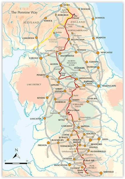
Productomschrijving: De Pennine Way National Trail met OS kaart boekje. De route van de 320 km van Edale naar Kirk Yetholm duurt drie weken om te lopen en is geschikt voor fit en langeafstand ervaren wandelaars. De route doorkruist het Peak District NP, de Yorkshire Dales NP en de North Pennines nationale parken. Bevat afzonderlijk boekje van de route.
Productdescription: Guidebook to the Pennine Way National Trail with OS map booklet. The 270 mile route from Edale to Kirk Yetholm takes three weeks to walk and is suitable for fit and experienced long distance walkers. The route crosses the Peak District, Yorkshire Dales and North Pennines National Parks. Includes separate OS 1:25,000 map booklet of the route.
Seasons:
This National Trail is essentially a summer walk, though it can be completed in spring or autumn, the winter months are solely for dedicated and experienced long-distance walkers.
Centres:
Edale, Crowden, Hebden Bridge, Cowling, Gargrave, Malham, Horton in Ribblesdale, Hawes, Keld, Bowes, Middleton-in-Teesdale, Dufton, Alston, Hadrian's Wall, Bellingham, Byrness, Kirk Yetholm.
Difficulty:
The Pennine Way is a challenging walk, often across high, exposed moorlands. No problems on fine, sunny days, but some parts can be exceptionally difficult in bad weather. In mist, careful navigation is required, but on the whole the route is well-signposted. Suitable for backpackers and youth hostellers, but ample B&B accommodation is also available. Previous long-distance walking experience is an advantage.
Must See:
Peak District National Park - Kinder Scout, Bleaklow and Black Hill; South Pennines - Stoodley Pike and Brontë Country; Yorkshire Dales National Park - Malham Cove, Pen-y-Ghent and Great Shunner Fell; North Pennines AONB - Teesdale, High Cup and Cross Fell; Northumberland National Park - Hadrian's Wall and the Cheviot Hills.
Locatie op kaart
Artikelen uit dezelfde regio
Wandelkaart XT25 Peak District Zuid - Harvey maps • 9781851375523
Wandelkaart - Peak District Zuid - XT25 - Harvey maps Productomschrijving: Het Nationaal park Peak District is een zeer heuvelrijk nationaal park in het noorden van Engeland. Meestal wordt het onderverdeeld in het noordelijke Dark Peak, waar vooral veel heidegebieden zijn, en het zuidelijke White Peak, waar de meeste mensen wonen. Het is een bekend recreatiegebied en een plaats om bepaalde…
Wandelgids Great Walks on the England Coast Path - Cicerone • 9781852849894
Great Walks on the England Coast Path - Cicerone Engelse omschrijving: At around 4500 km (2800 miles), the England Coast Path is the longest coastal trail in the world. This inspirational large-format guide presents a handpicked selection of 30 highlight sections, offering a taste of England's stunning and diverse shoreline. Routes range from 9 to 45km, spanning between 3 hours and 2 days,…

Fietsgids Peak District cycling - Cicerone • 9781852848781
Fietsgids - Peak District cycling - Cicerone Productomschrijving: Fietsgids over het Peak district, die routes beschrijft in- en rond het National Park, op de weg of op de talrijke fietsroutes. 20 dag routes en één meerdaags fietsroute door het Peak District. Allemaal gemakkelijk toegankelijke routes vanuit Sheffield en Manchester, met routes vanaf het charmante Derbyshire, met steden zoal…
Wandelgids Yorkshire Dales South & West walking guide- Cicerone • 9781852848859
Wandelgids - Yorkshire Dales South & West walking guide- Cicerone Productomschrijving: Deel 2 van een 2-delige gidsen set omvat 44 wandelingen in het zuiden en het west van de Yorkshire Dales, incl het 23km lange "Three Peak cicuit" door Pen-y-Ghent, Whernside & Ingleborough. De andere, meestal bezienswaardige routes van ongeveer 13km ovatten de regio's tussen Sedbergh, Kirkby Lonsdale, Se…
Wandelkaart 269 Chesterfield & Alfreton- Derbyshire - OSI • 9780319471418
Wandelkaart Chesterfield & Alfreton - Derbyshire East Midlands Omvat ook: Sutton in Ashfield & Bolsover. Productbeschrijving: OS Explorer kaart 269 omvat Chesterfield, Sutton in Ashfield en Alfreton. Er vallen een aantal parken om te ontdekken, evenals deel van de Trans Pennine Trail. De Five Pits Trail in Grassmoor is open voor fietsers, wandelaars en ruiters. De OS Explorer kaart voo…