
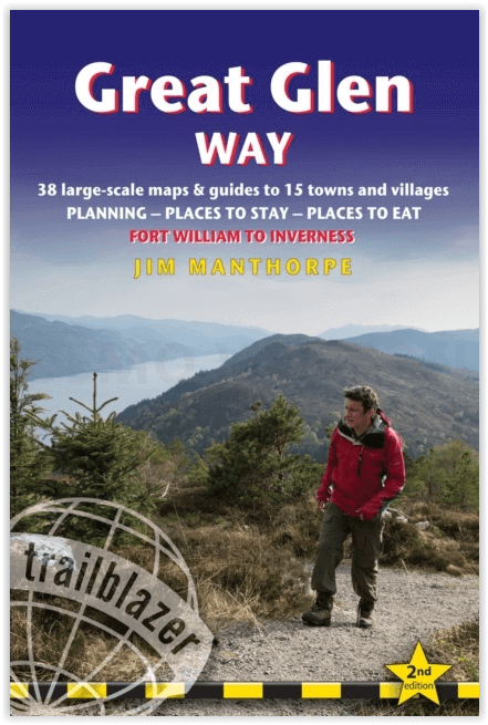
Wandelgids The Great Glen Way - Trailblazer
The Great Glen Way begint waar de West Highland Way eindigt
Korte omschrijving
The Great Glen Way - Trailblazer Publications Productomschrijving: The Great Glen Wayfrom Fort William to Inverness. Het langeafstandswandelpad Great Glen Way begint waar de West Highland Wa...

Specificaties
- Uitgever: Trailblazer Publications
- ISBN-13: 9781912716104
- HOOFDCATEGORIEËN: Wandelgids
- Activiteiten: Wandelen, Hiking & Trekking
- Regio: Highlands, Schotland
- Land: Schotland
- Historische wandelroutes: The Great Glen Way (119 km)
- Blz.: 192
- Afmeting: 12x18
- Editie: 2
- Taal: Engels
Volledige omschrijving
The Great Glen Way - Trailblazer Publications
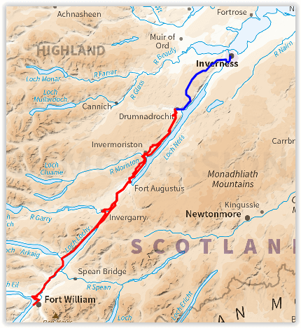
Productomschrijving: The Great Glen Wayfrom Fort William to Inverness. Het langeafstandswandelpad Great Glen Way begint waar de West Highland Way eindigt - in Fort William - en volgt de breuklijn van de Great Glen om na 79 mijl (127 km) te eindigen in Inverness. Het pad loopt langs Loch Lochy, Loch Oich en Loch Ness en volgt ook het jaagpad van het Caledonisch Kanaal. Het is een relatief gemakkelijke wandeling van een week in een prachtig Highland landschap, maar er is een hooggelegen optie tussen Fort Augustus en Drumnadrochit die een nog beter uitzicht op de bergen biedt.
192 pages,
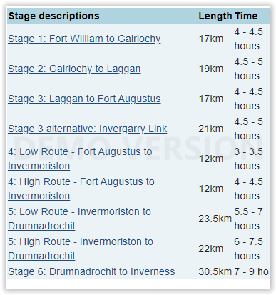
38 trail maps + 10 town plans
40 colour photos + 4pp colour flower guide
8 stage maps + 2 overview maps
Engelse omschrijving: The Great Glen Way long-distance footpath begins where the West Highland Way ends – at Fort William – and follows the Great Glen faultline to finish at Inverness after 79 miles (127km). The trail passes Loch Lochy, Loch Oich and Loch Ness and also follows the towpath of the Caledonian Canal. It’s a relatively easy week-long walk amongst beautiful Highland scenery but there’s a high level option between Fort Augustus and Drumnadrochit that gives even better mountain views.
Features:
1. Unique mapping features – In many walking guides the reader has to read a route description then try to relate it to the map. Our guides are easier to use because walking directions, tricky junctions, places to stay and eat, points of interest and walking times are all written onto the maps themselves in the places to which they apply. With their uncluttered clarity, these are not general-purpose maps but fullyedited maps drawn by walkers for walkers. Downloadable GPS waypoints also included.
2. The largest scale walking maps available – At just under 1:20,000 (8cm or 31/8 inches to 1 mile) our maps are bigger than even the most detailed walking maps currently available in the shops.
3. An all-in-one guide – Trailblazer guides include practical information not usually found in walking guides to the UK: reviews of places to stay, places to eat, attractions along the way and detailed public transport information showing all access points on the path, for weekend and day walkers.
Locatie op kaart
Overzichtskaarten

Hystorische wandel- en fietsroutes
Hystorische wandel- en fietsroutes

Producten op de overzichtskaart
Klik op een product om naar de detailpagina te gaan.
- Wandelkaart - South Downs Way - Harvey maps
- Wandelgids - North Yorkshire historic walks - Cicerone
- Wandelkaart OL13 - Brecon Beacons NP - Eastern area - OSI
- Wandelgids - Pilgrim Pathways walking guide - Trailblazer
- Wandelgids - The Great Glen Way - Trailblazer
- Wandelgids - Hadrian's wall Path - Knife Edge
- Wandelgids - Hadrian's Wall Path - Trailblazer
- Wandelkaart XT40 - Offa's Dyke Path - Harvey Maps
- Wandelkaart OL43 - Hadrian's Wall - OSI
- Wandelkaart 351 - Dunbar & North Berwick- Schotland - OSI
- Wandelgids - Walking in the Forest of Dean - Cicerone
- Wandelkaart 130 - Salisburry & Stonehenge- Wiltshire - OSI
- Wandelkaart 256 - Wrexham- Wrecsam & Llangollen - OSI
- Wandelkaart 130 - Salisbury & Stonehenge- Wiltshire - OSI
- Wandelgids - John Muir Trail - Cicerone
- Wandelkaart - Rob Roy Way National trail - Harvey maps
- Wandelkaart - Hadrian's Wall Path - Harvey maps
- Wandelkaart - Offa's Dyke Path- Route Map Booklet - Cicerone
Artikelen uit dezelfde regio

Wandelkaart 444 Helmsdale & Strath of Kildonan - OSI • 9780319472965
Wandelkaart Helmsdale & Strath of Kildonan - Highland Schotland Productbeschrijving: OS Explorer kaart 444 toont Strath van Kildonan en Helmsdale. Er was hier iets van een kleine goudkoorts in 1869 - maar als u daar naar op zoek bent zult u nu waarschijnlijk teleurgesteld worden. Ondanks, de ruige landschappen en externe paden nog steeds te vinden zijn. De OS Explorer kaart voor Helmsdale …

Wandelkaart 443 Ben Kilbreck- Ben Armine - Schotland - OSI • 9780319246863
Wandelkaart Ben Kilbreck- Ben Armine - Highlands Schotland Productbeschrijving: 443 / Ben Kilbreck, Ben Armine, Highlands, Schotland - OS Explorer kaart blad 443 toont de Munro Meall nan Con, Ben Klibreck, Loch Choire en Loch Shin.Toegang via de A836 aan de westzijde van de kaart - alleen onopgemaakte sporen en voetpaden hulpen u verder. De OS Explorer kaart voor Ben Klibreck & Ben Arm…

Wandelkaart 27 Nairn & Forres Highland's Schotland - OSI • 9780319473504
Wandelkaart Nairn & Forres - Highland's Schotland Productbeschrijving: OS Landranger kaart 27 toont Moray Firth, net ten oosten van Inverness. De kust stad van Nairn is een populaire vakantiebestemming, of neem de Moray Coastal Trail langs Forres aan Findhorn. De OS Landranger kaarten reeks heeft betrekking op Groot-Brittannië met 204 gedetailleerde kaarten, perfect voor dagtochten en kort…

Wandelkaart OL60 Lochindorb & Grantown-on-Spey - OSI • 9780319469781
Wandelkaart Lochindorb & Grantown-on-Spey - Highland's Productbeschrijving: Toont het Noord-westelijke deel van Cairngorms National Park, plus Strathdearn en de rivier Findhorn. OS Explorer kaart OL 60 is de perfecte kaart voor wandelen, lopen, rijden of een buiten buiten activiteit. Deze kaart vervangt de vorige OS Explorer kaart 418 voor dit gebied. Deze kaart beschikt over de Dava way &…

Wandelkaart 21 Dornoch & Alness Highland's Schotland - OSI • 9780319261194
Wandelkaart 2Dornoch & Alness - Highland's Schotland Productbeschrijving: Kaart nummer 21 in de OS Landranger kaarten reeks, is de ideale kaart om te gebruiken bij het verkennen van de omgeving van Dornoch Firth, Cromarty Firth en de steden van Dornoch, Tain en Invergordon Alness. Deze kaart heeft ook betrekking op het gebied rond Skiboo Castle en Dornoch Castle. De OS Landranger kaart…