Wandelgids Reivers Way through historic Northumberland- Cicerone
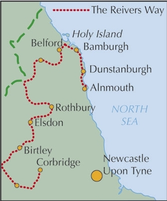
De Reivers Way van Corbridge naar Alnmouth in Northumberland
Korte omschrijving
Wandelgids- Reivers Way through historic Northumberland- Cicerone Productomschrijving: Een handige zakformaat handleiding voor iedereen die van plan is om de Reivers Way af te lopen. Volg in...

Specificaties
- Uitgever: CICERONE Press
- ISBN-13: 9781852844981
- HOOFDCATEGORIEËN: Wandelgids
- Activiteiten: Wandelen, Hiking & Trekking
- Auteur: Paddy Dylan
- Regio: North & North East England, Northhumberland, North England
- Land: England
- Lange afstand wandelroutes: Reivers Way (193 km)
- Blz.: 160
- Afmeting: 12x17
- Editie: 1
- Taal: Engels
Volledige omschrijving
Wandelgids- Reivers Way through historic Northumberland- Cicerone
Productomschrijving: Een handige zakformaat handleiding voor iedereen die van plan is om de Reivers Way af te lopen. Volg in de voetstappen van de border reivers op deze 150 mijl lange route, die loopt van Corbridge naar Alnmouth. De reivers route dwaalt door wilde en schilderachtige delen van Northumberland, en kan worden gewandeld in 9 dagen. Het boek bevat ook varianten en alternatieve routes. Wandelen in de voetstappen van de beruchte border reivers en ontdek hoe zij eeuwen van conflicten en oorlog overleefden.
Product description: A guidebook to walking the Reivers Way. Follow in the footsteps of the border reivers on this 240km (150 mile) route running from Corbridge to Alnmouth. The reivers route wanders through wild and scenic parts of Northumberland, and can be walked in 9 days. The book also includes variants and alternative routes.
Seasons:
Spring can be the most attractive time; in summer accommodation needs to be booked ahead but ferries will be running to the Farne Islands; weather is less reliable in the autumn; in winter some accommodation providers will be closed and walking may be harder (in deep snow or after prolonged rain).
Centres:
Newcastle-upon-Tyne, Corbridge, Rothbury, Bamburgh, Alnwick, Alnmouth.
Difficulty:
The Reivers Way is straightforward but sometimes the walk is remote and not specifically waymarked so navigation skills are required; terrain is varied; the route is described in 9 day stages but experienced long-distance walkers could tackle it in a week.
Must See:
North Pennines Area of Outstanding Natural Beauty; Hadrian’s Wall; Northumberland National Park; Cheviot Hills; Northumberland Heritage Coast; Farne Islands; dramatic castles and wild, empty landscapes.

Locatie op kaart
Artikelen uit dezelfde regio

Wandelgids The Pennine Way - Cicerone • 9781852849061
Wandelgids - The Pennine Way - Cicerone Productomschrijving: De Pennine Way National Trail met OS kaart boekje. De route van de 320 km van Edale naar Kirk Yetholm duurt drie weken om te lopen en is geschikt voor fit en langeafstand ervaren wandelaars. De route doorkruist het Peak District NP, de Yorkshire Dales NP en de North Pennines nationale parken. Bevat afzonderlijk boekje van de rout…

Wandelkaart 332 Alnwick Amble - Northumberland - OSI • 9780319245842
Wandelkaart Alnwick Amble - Northumberland England 332 - Alnwick & Amble NBorthumberland - Kaart nummer 332 in de OS Explorer reeks heeft betrekking op de Northumbrian kust van Embleton Bay naar Amble en het binnenland zover of de bron van de rivier Aln. Plekken om te bezoeken zijn onder andere: Craster, kasteel van Alnwick, Warkworth Castle, Craster kasteel, lange Crag en Rothbury. De OS …

Wandelgids Yorkshire Dales South & West walking guide- Cicerone • 9781852848859
Wandelgids - Yorkshire Dales South & West walking guide- Cicerone Productomschrijving: Deel 2 van een 2-delige gidsen set omvat 44 wandelingen in het zuiden en het west van de Yorkshire Dales, incl het 23km lange "Three Peak cicuit" door Pen-y-Ghent, Whernside & Ingleborough. De andere, meestal bezienswaardige routes van ongeveer 13km ovatten de regio's tussen Sedbergh, Kirkby Lonsdale, Se…

Wandelkaart 81 Alnwick & Morpeth Northumberland - OSI • 9780319263709
Wandelkaart Alnwick & Morpeth - Northumberland England Productomschrijving: De OS Landranger kaarten reeks heeft betrekking op Groot-Brittannië met 204 gedetailleerde kaarten, perfect voor dagtochten en korte pauzes. Elke kaart bevat alle informatie die u nodig heeft om dit lokaal gebied te leren kennen en omvat plaatsen van belang, toeristische informatie, picknickplaatsen en campings, pl…

Wandelgids North Yorkshire historic walks - Cicerone • 9781852843892
Wandelgids - North Yorkshire historic walks - Cicerone Productomschrijving: Een gids over historische wandelingen in North Yorkshire, in 20 meestal circulaire routes. Zij brengen u van open heidegebied en blootgestelde delen van heuvel en kliffen naar de meer beschutte dales en de straten van York. Wandelingen bevatten Skipton Castle, Ripon en Fountains Abbey, Ripley Castle, Castle Howard,…


