Fietskaart 02 Cotswold AONB cycling map - Goldeneye
National Cycle Network - Traffic-Free Family Routes/Trails
Korte omschrijving
Fietskaart Cotswold cycling map - Goldeneye Productomschrijving: De Cotswolds zijn een AONB regio, een regio van uitmuntend natuurschoon. In Engeland geklasseerd als AONB, Area of Outstandin...

Specificaties
- Uitgever: Goldeneye
- ISBN-13: 9781859653036
- Activiteiten: Fietsen / VTT / MTB
- Regio: Oxfordshire west England, Somerset South West England, Warwickshire, West Midlands, Wiltshire, West England, Worcestershire, West England
- Land: England
- AONB - Area of Outstanding Beauty: Cotswolds AONB
- Schaal: 1:100000
- Afmeting: 12x24
- Editie: 10
- Taal: Engels
Volledige omschrijving
Fietskaart Cotswold cycling map - Goldeneye
Productomschrijving: De Cotswolds zijn een AONB regio, een regio van uitmuntend natuurschoon. In Engeland geklasseerd als AONB, Area of Outstanding Natural Beauty. Zo heeft de UK er een pak verdeeld over het land. De Cotswold kun je een beetje vergelijken met Cornwall, maar dan zonder de kustlijnen. Hier vindt je prachtige landschappen en trails voor fietsers van jong naar ouder.
Engelse omschrijving: The Cotswolds are ideal for the touring cyclist - representing England at its very best. Long, winding lanes connect villages with beautiful churches, excellent pubs and delicious tea rooms. The landscape these cycle routes pass through is rich in imagery, from rolling pastures, dry-stone walls and trickling trout streams, to honey-coloured stone cottages in sleepy hamlets.
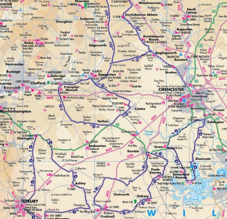
• 27 circular routes overprinted on map
• National Cycle Network routes 5, 41, 45 and 48 are illustrated, and the Traffic-Free Family Cycling Trails: The Stroud Valley Cycle Trail, The Oxford Waterway and the Forest of Dean Family Trails.
National Cycle Network (NCN)
1. NCN Route 5. Stratford-upon-Avon – Banbury – Oxford. The Traffic-Free sections run along the Oxford Waterway (see below), from Oxford to Woodstock and northwards, and a couple of short sections from Bodicote, south of Banbury (see map reference Q1).
2. NCN Route 41. Gloucester & Sharpness Canal – Bristol. The Traffic-Free section runs between Frampton-on-Severn and Slimbridge for about 6km/4 miles.
3. NCN Route 45. Gloucester – Salisbury via Stroud, Cirencester & Swindon. There remain gaps in the route. The Traffic-Free sections runs between South Cerney and Cricklade for about 10km/7 miles.
4. NCN Route 48. Northleach - Cirencester.
5. Regional Route 57. Northleach – Witney. The Traffic-Free section runs between Minster Lovell and Witney for about 5km/3 miles.
Traffic-Free Family Routes/Trails
1. Stroud Valley Cycle Trail. 15km/9.5miles. Former railway track along the Nailsworth Valley. Start at Kings Stanley car park, cross A46, to Dudbridge Roundabout and follow trail to Egypt Mill. (D8)
2. The Oxford Waterway. 15km/9.5miles. Trail along canal towpath. Best started from Wolvercote car park. Suggest you first head north towards Duke’s Lock, Kidlington Green Lock, Roundham Lock and the Jolly Boatman Inn, then onto Thrupp. Return to Wolvercote, and south to Oxford City Centre. (R7)
3. Forest of Dean Family Trail. 15km/9miles. Former mining tracks now converted into a web of criss-crossing biking trails. This circular route starts from Pedalabikeaway – Drybrook Road – Dilke Hospital – Blackpool Brook – Burnt Log – Connop Wharf with off-shoot trail to Coleford via Parkend. The routes are waymarked. A detailed map is available from the bike hire hut. Refreshments. (A6)

Artikelen uit dezelfde regio

Reisgids Cotswolds AONB - Rough Guides • 9781839059728
The Cotswolds AONB - Rough Guides Productomschrijving: Deze omvat het Cotswolds gebied in zuid-oost Engeland. Een gebied van uitmuntend natuurschoon, of in andere meer lokalere woorden, een AONB area, of Area of Outstanding Natural Beauty. Bij ons is dat bijvoorbeeld de westhoek, het Zwin, enz... Deze reisgids biedt u deze regio inclusief de locaties van Stratford-Uppon-Avon & Oxford die a…

Fietskaart & Mtb kaart The Cotswolds - Goldeneye • 9781859652589
Fietskaart en Mtb kaart - The Cotswolds - Goldeneye Productomschrijving: De Cotswolds is een AONB streek, (Area of Outstanding Natural Beauty) in centraal Engeland. Het gebied omvat de graafschappen Somerset, Warwickshire, Wiltshire, Oxfordshire & Worcestershire, maar het grootste deel ligt in Gloucestershire. Er wordt sinds eeuwen kalksteen uit de steengroeven gewonnen in deze regio, en d…

Wandelgids Cotswolds AONB 50 walks guide - AA Publishing • 9780749583224
Cotswolds AONB - 50 walks guide - AA Publishing Productomschrijving: Wandelen is een van de favoriete vrijetijdsbestedingen van Groot-Brittannië. AA 50 Walks in the Cotswolds bevat een verscheidenheid aan uitgestippelde wandelingen van 3 tot 12 km, geschikt voor alle niveaus. Het boek bevat alle praktische details die u nodig hebt, vergezeld van boeiende achtergrondinformatie over de gesch…

Wandelkaart 138 Kidderminster & Wyre Forest - OSI • 9780319262368
Wandelkaart Kidderminster & Wyre Forest - England Productbeschrijving: OS Landranger kaart 138 van Kidderminster & Wyre Forest omvat ook Bridgnorth, Abdon Stanton Lacy, Bayton, Stoke Bliss, Brimfield, Ludlow, Highley, Six Ashes, Chetton, en Much Wenlock. De OS Landranger kaarten reeks heeft betrekking op Groot-Brittannië met 204 gedetailleerde kaarten, perfect voor dagtochten en korte pauz…

Wandelgids Cotswold Classic Walks - Goldeneye • 9781859652916
Cotswold Classic Walks - Goldeneye Productomschrijving: Met 25 rondwandelingen helpt dit boek u een uitvalsbasis te vinden om de auto te ontvluchten en te genieten van een weekend vol frisse lucht en beweging.... Sommige wandelingen bieden verschillende routemogelijkheden en links naar andere wandelingen. Hoe beslist u welke wandeling u gaat doen? - Waar zijn de mooiste uitzichten? - W…


