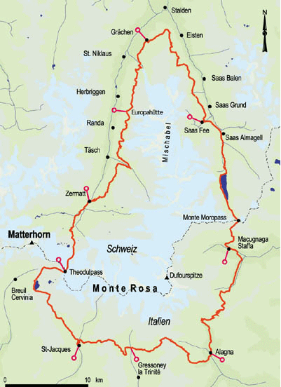
Wandelkaart Tour of Monte Rosa - Knife Edge
Mont Blanc- Grand Combin- Weisshorn- Zinalrothorn- Dom
Korte omschrijving
Tour of Monte Rosa - Knife Edge Productomschrijving: Deze omvat De beste kaart voor de Ronde van Monte Rosa. Dit is de enige beschikbare kaart die de hele route en varianten op één vel weerg...

Specificaties
- Uitgever: Knife Edge Outdoor Limited
- ISBN-13: 9781912933549
- HOOFDCATEGORIEËN: Wandelkaart
- Activiteiten: Wandelen, Hiking & Trekking
- Auteur: Andrew McCluggage
- Regio: Wallis
- Land: Zwitserland
- Toepasselijke bergketen: Monte Rosa, Wallis Zwitserland - Grens Italië
- Schaal: 1:40000
- Afmeting: 12x24
- Editie: 1
- Taal: Engels
- Reeks: Knife Edge, The Great treks of the Alps
Volledige omschrijving
Tour of Monte Rosa - Knife Edge
Productomschrijving: Deze omvat De beste kaart voor de Ronde van Monte Rosa. Dit is de enige beschikbare kaart die de hele route en varianten op één vel weergeeft: perfect voor planning en navigatie. 1:40.000 - grotere schaal en meer detail dan elke andere kaart. de ronde brengt u van het startpunt in Chamonix tot in het Zwitserse Zermatt.
Deze massieven komt u tegen:
Mont Blanc, Grand Combin, the Weisshorn, the Zinalrothorn, the Dom, the Täschhorn, the Breithorn and the Matterhorn.
Engelse omschrijving: The best sheet map for the Tour of Monte Rosa. This is the only map available that displays the entire route and variants on a single sheet: perfect for planning and navigation. 1:40,000 - larger scale and more detail than any other map.
Made specifically for the Tour of Monte Rosa by Knife Edge Outdoor Guidebooks:
• English/French/German map key
• 1:40,000
• Numerous variants
• Includes free GPX downloads for the trail
• GPS compatible
• Tougher than traditional maps: try to tear me!
• More water-resistant than traditional maps
• Lighter than traditional maps
• Huts/accommodation marked on the map
The Walker’s Haute Route is an incredible trek between the two most famous mountain towns in the Alps. Travelling from Chamonix in France to Zermatt in Switzerland, you will start at Mont Blanc and finish at the Matterhorn. On the way, pass the largest collection of snowy 4000m summits in the Alps: Mont Blanc, Grand Combin, the Weisshorn, the Zinalrothorn, the Dom, the Täschhorn, the Breithorn and the Matterhorn, to name a few. The sister trek to the Tour du Mont Blanc crosses unspoilt and remote mountain terrain: amazing glaciers, snow frosted summits, beautiful valleys and pastures, shimmering lakes, carpets of wild flowers and the soothing sound of cow bells. This trek should be on your hiking bucket list.
• 206km
• 10-14 days
• 14,000m of altitude gain
• 12 mountain passes
• 2 countries: France and Switzerland.

Artikelen uit dezelfde regio

Wandelgids Tour des combins two-way trekking guide - Knife Edge • 9781912933181
Tour des combins two-way trekking guide - Knife Edge Productomschrijving: De definitieve gids voor de Tour des Combins: de nieuwe bucketlist-trekking roiute in de Zwitserse/Italiaanse Alpen. Een geweldig alternatief voor de bekendere Tour du Mont Blanc ( TMB) Opgelet, dit is geen gemakkelijke trek, de route is slechts 100 km maar de stijgingen en dalingen, maken de route lang en zwaar. Zor…


Wandelkaart 88 Monte Rosa - Kompass • 9783991218883
Wandelkaart Monte Rosa - Kompass Productomschrijving: Het 50 km lange Monte Rosa bergmassief ligt in het Zwitsers-Italiaanse grensgebied, in de Walliser Alpen. De hoogste top is de 4.634 m hoge Dufourspitze, de hoogste berg van Zwitserland. - De rit omhoog met de beroemde Gornergratbahn naar de 3.135 m hoge Gornergrat is spectaculair: het uitzicht strekt zich uit van de ijswereld van de Mo…

Fietsgids Fietsen door de Alpen en Piemonte naar de zee - Benjami • 9789077899359
Fietsen door de Alpen en Piemonte naar de zee - Benjaminse Productomschrijving: Fietsroute Door de Alpen en Piemonte naar de Zee Aantal detailkaarten: 67, schaal 1:100.000 Aantal stadskaarten: 6, schaal varieert Afstand: 775 km + 170 km langs Italiaanse Meren + 125 km via Turijn Moeilijkheidsgraad: Gemiddeld, voor de echte zwaardere beklimmingen zoals de Simplonpas, kan men ee…

Wandelkaart 5006 Matterhorn & Mischabel - Swisstopo • 9783302050065
Wandelkaart Matterhorn & Mischabel Zwitserland - Swisstopo Omvat: Landeskarte der Schweiz & Zusammensetzung Productomschrijving: De Matterhorn is één van de bekendste bergen ter wereld. De berg is 4478 m hoog, gelegen in de Walliser Alpen, op de grens van Zwitserland (Wallis) en Italië (Valle d'Aosta). De mogelijke wandelpaden starten allemaal vanuit de vallei van Zermatt beneden het …

Klimgids Walliser Alpen 4/5 - vom Theodulpass zum Simplon - SAC • 9783859022904
Walliser Alpen 4/5 - Vom Theodulpass zum Simplon De Walliser Alpen! Productomschrijving: Deze gletsjer bedekte westelijke Alpen, bieden een onvergetelijke serie van pieken, van klassieke alpinisme en bergbeklimmen. Deze volledig herontworpen alpine gids beschrijft de veilige en lonende routes tussen de theodul pass en Simplon. De klimatologische veranderingen van het recente verleden w…


