
Wandelkaart Néouvielle- Gavarnie- Midi de Bigorre - Alpina
Parce National de Pyrénées Est

Korte omschrijving
Néouvielle- Gavarnie- Midi de Bigorre - Alpina Productomschrijving: Het Parc National des Pyrénées strekt zich uit over meer dan 100 kilometer, over 6 valleien, 2 departementen (Pyrénées-Atl...

Specificaties
- Uitgever: Editorial Alpina S.L.
- ISBN-13: 9788470110931
- HOOFDCATEGORIEËN: Wandelkaart
- Activiteiten: Wandelen, Hiking & Trekking
- Regio: Nouvelle-Aquitaine, Frankrijk, Occitanië, Frankrijk
- Land: Frankrijk
- Departement: Hautes-Pyrénées (65), Pyrénées-Atlantiques (64)
- Regionale parken: Réserve Naturelle Nationale du Néouvielle, Frankrijk
- Schaal: 1:30000
- Afmeting: 12x21
- Taal: Engels
- Reeks: Alpina 30
Volledige omschrijving
Néouvielle- Gavarnie- Midi de Bigorre - Alpina
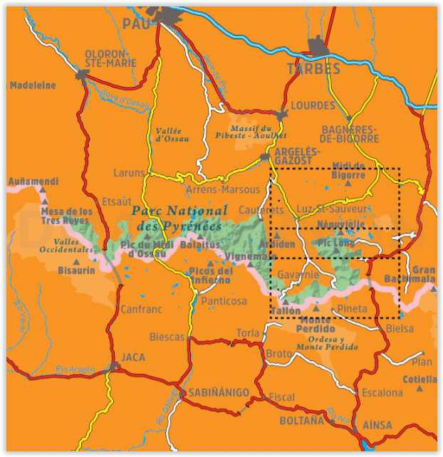
Productomschrijving: Het Parc National des Pyrénées strekt zich uit over meer dan 100 kilometer, over 6 valleien, 2 departementen (Pyrénées-Atlantiques en Hautes-Pyrénées) en twee regio's (Nouvelle Aquitaine en Occitanie). Deze twee kaarten hebben betrekking op het oostelijke deel van het park, met inbegrip van het Réserve Naturelle Nationale du Néouvielle, de keteldalen van Gavarnie, Estaubé, Troumouse en Barroude, evenals de Pic du Midi de Bigorre, buiten het beschermde gebied.
Engelse omschrijving: The Parc National des Pyrénées stretches over one hundred kilometers, across six valleys, two departments (Pyrénées-Atlantiques and Hautes-Pyrénées), and two regions (Nouvelle Aquitaine and Occitanie), along the border with Spain. These two maps cover the eastern sector of the park, including the Réserve Naturelle Nationale du Néouvielle, the cirques of Gavarnie, Estaubé, Troumouse, and Barroude, as well as the Pic du Midi de Bigorre, outside the protected area
2 hiking maps in one folder
•Scale 1:25.000
•Equidistance contours: 10 m distance
•Master contours: at 50 m
•Shady relief
•Compatible with GPS
•Land use symbolized at three levels
20 Hikes:
• Geographic information
• The top 10 touristic highlights
Covered area: Parc National des Pyrénées. Hautes-Pyrénées. Néouvielle, Gavarnie, and Midi de Bigorre sector.Map features: Two topographic maps, scale 1:30.000, with hiking and tourist information: Mountain huts, signposted footpaths (GR’s, PR’s, local), routes to the summits, access to the starting points of the hikes, etc
The folding flap includes:
• 20 Hikes
• Geographic information
• The top 10 touristic highlights
Overzichtskaarten

ALPINA Editorial - Wandelkaarten Oostelijke Pyreneeën 38 > 51
ALPINA Editorial - Wandelkaarten Oostelijke Pyreneeën 38 > 51

Producten op de overzichtskaart
Klik op een product om naar de detailpagina te gaan.
- Wandelkaart 39 Catllaràs Picancel - Ed. Alpina
- Wandelkaart 40 Lluçanès - Llucanes - Ed. Alpina
- Wandelkaart 41 Puigmal - Vall de Nuria - Ulldeter - Ed. Alpina
- Wandelkaart 44 Capçaleres del Ter i del Freser PN - Ed. Alpina
- Wandelkaart 48 Alta Garrotxa - Ed. Alpina
- Wandelkaart 49 Garrotxa zona volcanica - Ed. Alpina
- Wandelkaart Collsacabra - Vall de Sau - Ed. Alpina
- Wandelkaart Cambra d'Ase - Carança - Ed. Alpina
- Wandelkaart Vall de Lord - Port del Comte - Ed. Alpina
- Wandelkaart Carlit 50 Estanys - Ed. Alpina
- Wandelkaart Néouvielle- Gavarnie- Midi de Bigorre - Ed. Alpina
Artikelen uit dezelfde regio

Wandelgids Gironde - 44 balades en famille - Ed. Glénat • 9782344050682
La Gironde - 44 balades en famille - Ed. Glénat Productomschrijving: Van het Bassin d'Arcachon tot de wijngaarden van Saint-Emilion, 44 wandelingen voor het hele gezin op minder dan een uur rijden van de Bordeaux streek. Er worden stads-, plattelands- en kustwandelingen aangeboden in de zeven geografische sectoren van de Gironde: in Entre-deux-Mers, een land van heuvels afgewisseld met vre…

Wandelgids Pays Basque entre montagne & littoral - Ed. Sud-Ouest • 9782817711294
Pays Basque entre montagne & littoral - Sud-Ouest Productomschrijving: Wandelen in de Pyreneeën in Frans Baskenland, in het departement van de Pyrénées-Atlantiques. Deze gids brengt u 26 wandelroutes tussen de bergen en de kustlijn. Een deel van de Pyreneeën die niet veel word besproken in wandelgidsen, wat eigenaardig is, want dit deel is nochtans heel mooi wandelgebied. Een unieke wandel…

Wandelkaart 1642 SB Villeneuve-de-Marsan & Nogaro - IGN • 9782758541332
Wandelkaart 1642 SB - Villeneuve-de-Marsan & Nogaro Productomschrijving: Villeneuve-de-Marsan & Nogaro zijn gemeentes in het Franse departement Landes in de regio Nouvelle-Aquitaine. De plaats maakt deel uit van het arrondissement Mont-de-Marsan. Een gloed nieuwe reeks IGN kaarten: de oude versies met de Est en Ouest (E en O aanduiding achter het nummer van de kaart) verdwijnen en word…

Fietsgids Royan à Hendaye à vélo - Ed. Ouest-France • 9782737361944
Fietsgids Royan à Hendaye à vélo in de Gironde - France Productomschrijving: Royan naar Hendaye, 600 kilometer aan gemarkeerde kust paden in de Gironde, in de Landes en het Baskenland. Deze fietsgids bestaat uit: - 10 stappen zonder verhoging van tussen de 30 & 50 km over de Atlantische kust - 3 routes naar Bordeaux, het bekken van Arcachon aan de Garonne, en de Bayonne in Cambo-les-Bains.…

Wandelkaart 2644 OT Pézenas & Murviel-lès-Béziers - IGN • 9782758548799
TOPO Wandelkaart Pézenas & Murviel-lès-Béziers - IGN Productomschrijving: Pézenas & Murviel-lès-Béziers zijn gemeentes in het Franse departement Hérault in de regio Occitanie. De plaats maakt deel uit van het arrondissement Béziers. De TOP 25 kaarten, met nummers die eindigen op "T" hebben betrekking op gebieden van bijzonder toeristisch belang zoals de Alpen, de Pyreneeën, De Cevennes…