
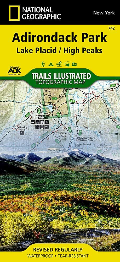
Wandelkaart 742 Adirondack Park - Lake Placid - Natgeo
Lake Placid- Essex County in New York
Korte omschrijving
TOPO Wandelkaart 742 - Adirondack Park - Lake Placid Productomschrijving : Adirondack park of mountains, een groter bebost deel van de staat New York. In dit geval gaat het over de locatie v...

Specificaties
- Uitgever: National Geographic
- ISBN-13: 9781566953573
- HOOFDCATEGORIEËN: Wandelkaart
- Regio: New York State, USA
- Land: Verenigde Staten van Amerika (USA)
- Regionale parken: Adirondack Park/Mountains NY, USA
- Schaal: 1:75000
- Afmeting: 10x19, 11x24
- Taal: Engels
Volledige omschrijving
TOPO Wandelkaart 742 - Adirondack Park - Lake Placid
Productomschrijving : Adirondack park of mountains, een groter bebost deel van de staat New York. In dit geval gaat het over de locatie van Lake Placid, New York. Lake Placid is niet enkel een maar maar ook een kleine stad, in Essex County in New York.
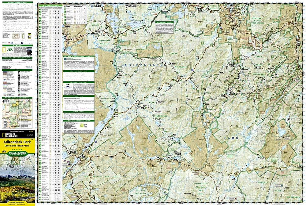
Engelse omschrijving : The largest park in the contiguous United States, Adirondack Park is a diverse mountain landscape of protected boreal forests and pristine waterways interspersed with over one hundred towns and villages. National Geographic's Trails Illustrated map of Adirondack Park combines unmatched detail with helpful information to offer an invaluable tool for making the most of your visit to this extraordinary region. Created in partnership with local land management agencies, this expertly researched map features key areas of interest including High Peaks Wilderness, Lake Placid, Sentinel Range Wilderness, Saranac Lakes Wild Forest, Lake Champlain, Giant Mountain Wilderness, Hurricane Mountain Wilderness, Split Rock Mountain Wild Forest, and Long Lake.
An extensive High Peaks Trail Chart will help you choose a trail that's right for your activity level and recreation use whether you're hiking, horseback riding, biking, snowshoeing, cross country skiing, or snowmobiling. Trails are clearly marked and include mileages between intersections. The map base includes contour lines and elevations for summits, passes and major lakes. Some of the many recreation features include: campgrounds, trailheads, fishing access, boat launch sites, and interpretive trails. Every Trails Illustrated map is printed on "Backcountry Tough" waterproof, tear-resistant paper. A full UTM grid is printed on the map to aid with GPS navigation.
Other features found on this map include: Adirondack Mountains, Algonquin Peak, Ampersand Mountain, Ausable River, Basin Mountain, Boundary Peak, Dix Mountain, Gothics, Gray Peak, Iroquois Peak, Little Marcy, MacIntyre Mountains, Mount Haystack, Mount Marcy, Mount Skylight, Otter Creek, Owls Head Mountain, Sentinel Range, Split Rock Mountain, Street Mountain, Tupper Lake, Upper Saranac Lake, Vanderwhacker Mountain.
Locatie op kaart
Overzichtskaarten

NAT GEO New York trail map
NAT GEO New York trail map

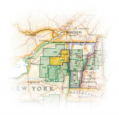
Producten op de overzichtskaart
Klik op een product om naar de detailpagina te gaan.
- Wandelkaart 738 Allegheny National Forest North - Nat Geo
- Wandelkaart 742 Adirondack Park - Lake Placid - Natgeo
- Wandelkaart 745 Adirondack Park - Old Forge & Oswegatchie
- Wandelkaart 746 Adirondack Park - Saranac & Paul Smiths
- Wandelkaart 747 Green Mountain National Forest- Vermont
- Wandelkaart 743 Adirondack Park - Lake George - Natgeo
- Wandelkaart 744 Adirondack Park - Northville & Raquette Lake
- Wandelkaart 748 Green Mountain National Forest
- Wandelkaart 756 Harriman- Bear Mountain & Sterling Forest parks
Artikelen uit dezelfde regio

Wandelkaart 743 Adirondack Park - Lake George - Natgeo • 9781566953634
TOPO Wandelkaart 743 - Adirondack Park - Lake George Productomschrijving: Adirondack park of mountains, een groter bebost deel van de staat New York. In dit geval gaat het over de locatie van Lake George in het noord oostelijk deel. Engelse omschrijving: National Geographic's Trails Illustrated map of Adirondack Park, Lake George - Great Sacandaga combines unmatched detail with helpful…

Reisgids New York Mini Rough Guide • 9781785732379
New York van Mini Rough Guide Productomschrijving: Deze gids in zakformaat is een handige, snelle referentiegids om te ontdekken wat er te doen is, wat er te zien is en hoe je je in New York kunt verplaatsen. Het behandelt topattracties zoals het Empire State Building, maar ook verborgen juweeltjes, zoals de High Line. Zo bespaar je tijd en ontdek je deze fascinerende stad nog beter. O…

Reisgids time to momo New York - Mo'media • 9789057679445
Reisgids time to momo New York - Mo'media Prductomschrijving: Natuurlijk staat The Big Apple bekend om de wolkenkrabbers, gele taxi's en beroemde bezienswaardigheden zoals Times Square, het Guggenheim Museum, het 9/11 Memorial en Central Park. Maar vooral de vele buurten met hun eigen karakter en sfeer maken New York tot zo'n inspirerende stad. Van exotisch Chinatown tot hippe shopping hoo…

Reisgids New York city - Lonely Planet • 9782816186406
New York city - Lonely Planet Déscription de product: Un guide de référence, à la fois pratique et culturel, pour un séjour inoubliable à New York. Une nouvelle édition tout en couleurs et avec de nombreuses photos. Un guide conçu pour les voyages en profondeur, avec un maximum d'informations pour organiser un séjour en fonction de ses intérêts, du temps et du budget disponible. Les pr…

Reisgids New York City - Anwb Extra • 9789018053413
Reisgids New York - Anwb Productomschrijving: Beleef New York met de vernieuwde reisgids ANWB Extra New York! De eindeloze optocht van extravagant geklede dames op Fifth Avenue, de straatventers met exotische waar in Chinatown, de muzikanten op Washington Square en de straatfeesten in Harlem. Al deze ingrediënten maken New York tot dé bestemming voor een leuke citytrip. De ANWB Extra r…