
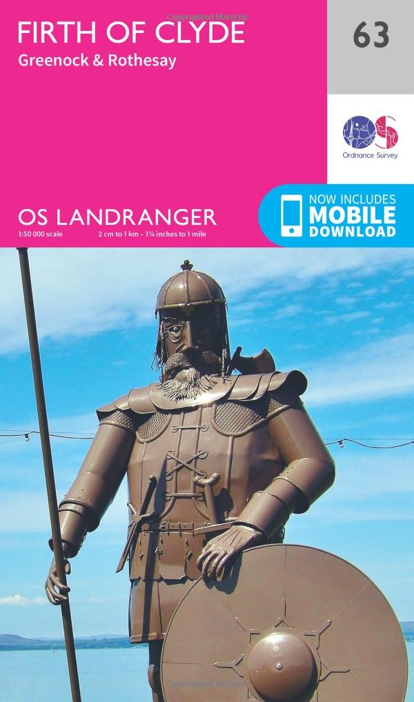
Wandelkaart 63 Firth of Clyde Argyl & Bute Schotland - OSI
Omvat Dunoon- Greenock- Port Glasgow- Rothesay & Millport
Korte omschrijving
Wandelkaart Firth of Clyde - Schotland Productbeschrijving: De diepe wateren rond de Firth of Clyde maakten hen ideaal voor zware schepen-gebouw in het verleden. Nu veel van de zware industr...

Specificaties
- Uitgever: Ordnance Survey
- ISBN-13: 9780319261613
- HOOFDCATEGORIEËN: Wandelkaart
- Activiteiten: Wandelen, Hiking & Trekking
- Regio: Argyll & Bute, Schotland
- Land: Schotland
- Schaal: 1:50000
- Afmeting: 13x23
- Taal: Engels
- Reeks: Landranger Series OSI
Volledige omschrijving
Wandelkaart Firth of Clyde - Schotland
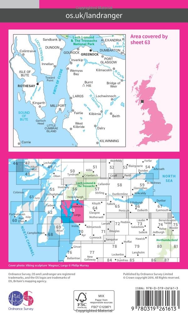
Productbeschrijving: De diepe wateren rond de Firth of Clyde maakten hen ideaal voor zware schepen-gebouw in het verleden. Nu veel van de zware industrie is verdwenen, heeft het gebied nu een weer oplevende wildlife, met inbegrip van zeehonden, bruinvissen, dolfijn. Kaart OS Landranger 63 omvat ook Dunoon, Greenock, Port Glasgow, Rothesay, Millport, Bridge of Weir, Kilbirnie, West Kilbride en Kilwinning.
De OS Landranger kaarten reeks heeft betrekking op Groot-Brittannië met 204 gedetailleerde kaarten, perfect voor dagtochten en korte pauzes. Elke kaart bevat alle informatie die u nodig heeft om dit lokaal gebied te leren kennen en omvat plaatsen van belang, toeristische informatie, picknickplaatsen en campings, plus doorgangsrechten informatie voor Engeland en Wales.
Productdiscription: The deep waters around the Firth of Clyde made them ideal for heavy ship-building in the past. Now much of the heavy industries have gone, the area now has a resurgent wildlife population, including seals, porpoise, dolphin and basking sharks (which are not really scary at all). OS Landranger map 63 also includes Dunoon, Greenock, Port Glasgow, Rothesay, Millport, Bridge of Weir, Kilbirnie, West Kilbride, and Kilwinning.
The OS Landranger Map series covers Great Britain with 204 detailed maps, perfect for day trips and short breaks. Each map provides all the information you need to get to know your local area and includes places of interest, tourist information, picnic areas and camp sites, plus Rights of Way information for England and Wales.
Locatie op kaart
Gekoppelde artikelen

Wandelkaart 63 Firth of Clyde Argyl & Bute Schotland - OSI • 9780319261613
standaard versieWandelkaart Firth of Clyde - Schotland Productbeschrijving: De diepe wateren rond de Firth of Clyde maakten hen ideaal voor zware schepen-gebouw in het verleden. Nu veel van de zware industrie is verdwenen, heeft het gebied nu een weer oplevende wildlife, met inbegrip van zeehonden, bruinvissen, dolfijn. Kaart OS Landranger 63 omvat ook Dunoon, Greenock, Port Glasgow, Rothesay, Millport, B…

Wandelkaart 63 Firth of Clyde- Argyl & Bute - Schotland - OSI • 9780319473863
weatherproof versieWandelkaart Firth of Clyde- Argyl & Bute - Schotland Productbeschrijving: De diepe wateren rond de Firth of Clyde maakte het ideaal voor de zware schepenbouw in het verleden. Nu veel van de zware industrie er weg is, heeft het gebied weer een oplevende wildlife, met inbegrip van zeehonden, bruinvissen, dolfijn en basking haaien. De OS Landranger kaarten reeks heeft betrekking op Groot-Brit…
Overzichtskaarten

OSI Landranger & Landranger Active - Zuid Schotland & Scotisch Borders
OSI Landranger & Landranger Active - Zuid Schotland & Scotisch Borders

Producten op de overzichtskaart
Klik op een product om naar de detailpagina te gaan.
- Wandelkaart 89 West Cumbria England - OSI
- Wandelkaart 89 West Cumbria England - OSI
- Wandelkaart 91 Appleby-in-Westmorland - OSI
- Wandelkaart 91 Appleby-in-Westmorland - OSI
- Wandelkaart 92 Barnard Castle Teesdale - England - OSI
- Wandelkaart 92 Barnard Castle Teesdale - England - OSI
- Wandelkaart 93 Middlesbrough & Darlington- England - OSI
- Wandelkaart 93 Middlesbrough & Darlington- England - OSI
- Wandelkaart 94 Whitby & Esk Dale- North Yorkshire - OSI
- Wandelkaart 94 Whitby & Esk Dale- North Yorkshire - OSI
- Wandelkaart 82 Stranraer & Glenluce - Schotland - OSI
- Wandelkaart 82 Stranraer & Glenluce - Schotland - OSI
- Wandelkaart 83 Newton Stewart & Kirkcudbright- Schotland - OSI
- Wandelkaart 83 Newton Stewart & Kirkcudbright- Schotland - OSI
- Wandelkaart 84 Dumfries & Castle Douglas- Schotland - OSI
- Wandelkaart 84 Dumfries & Castle Douglas- Schotland - OSI
- Wandelkaart 85 Carlisle & Solway Firth- Cumbria England - OSI
- Wandelkaart 85 Carlisle & Solway Firth- Cumbria England - OSI
- Wandelkaart 86 Haltwhistle & Brampton - OSI
- Wandelkaart 86 Haltwhistle & Brampton - OSI
- Wandelkaart 87 Hexham & Haltwhistle- England - OSI
- Wandelkaart 87 Hexham & Haltwhistle- England - OSI
- Wandelkaart 88 Newcastle upon Tyne- N.E. England - OSI
- Wandelkaart 88 Newcastle upon Tyne- N.E. England - OSI
- Wandelkaart 76 Girvan- South Ayrshire - Schotland - OSI
- Wandelkaart 76 Girvan- South Ayrshire -Schotland - OSI
- Wandelkaart 77 Dalmellington & New Galloway- Schotland - OSI
- Wandelkaart 77 Dalmellington & New Galloway- Schotland - OSI
- Wandelkaart 78 Nithsdale & Annandale- Schotland - OSI
- Wandelkaart 78 Nithsdale & Annandale- Schotland - OSI
- Wandelkaart 79 Hawick & Eskdale - Schotland - OSI
- Wandelkaart 79 Hawick & Eskdale - Schotland - OSI
- Wandelkaart 80 Cheviot Hills & Kielder Water - England - OSI
- Wandelkaart 80 Cheviot Hills & Kielder Water - England - OSI
- Wandelkaart 81 Alnwick & Morpeth - Northumberland - OSI
- Wandelkaart 68 South Kintyre & Campbeltown - OSI
- Wandelkaart 68 South Kintyre & Campbeltown - OSI
- Wandelkaart 69 Isle of Arran - Inner Hybrids - OSI
- Wandelkaart 69 Isle of Arran - Inner Hybrids - OSI
- Wandelkaart 70 Ayr- Kilmarnock & Troon- Schotland - OSI
- Wandelkaart 70 Ayr- Kilmarnock & Troon- Schotland - OSI
- Wandelkaart 71 Lanark & Upper Nithsdale - OSI
- Wandelkaart 71 Lanark & Upper Nithsdale - OSI
- Wandelkaart 72 Upper Clyde Valley- Lanarkshire - OSI
- Wandelkaart 72 Upper Clyde Valley- Lanarkshire - OSI
- Wandelkaart 73 Peebles- Galashiels & Selkirk - Schotland - OSI
- Wandelkaart 73 Peebles- Galashiels & Selkirk - Schotland - OSI
- Wandelkaart 74 Kelso & Coldstream - Schotland - OSI
- Wandelkaart 74 Kelso & Coldstream - Schotland - OSI
- Wandelkaart 75 Berwick-upon-Tweed- England - OSI
- Wandelkaart 75 Berwick-upon-Tweed - OSI
- Wandelkaart 62 North Kintyre & Tarbert - Schotland - OSI
- Wandelkaart 62 North Kintyre & Tarbert - Schotland - OSI
- Wandelkaart 63 Firth of Clyde- Argyl & Bute - Schotland - OSI
- Wandelkaart 63 Firth of Clyde- Argyl & Bute - Schotland - OSI
- Wandelkaart 64 Glasgow City Schotland - OSI
- Wandelkaart 64 Glasgow City Schotland- OSI
- Wandelkaart 65 Falkirk & Linlithgow - Edinburgh - OSI
- Wandelkaart 65 Falkirk & Linlithgow - West Schotland - OSI
- Wandelkaart 66 Edinburgh - Western Schotland - OSI
- Wandelkaart 66 Edinburgh - Western Schotland - OSI
- Wandelkaart 67 Duns- Dunbar & Eyemouth- Schotland - OSI
- Wandelkaart 67 Duns- Dunbar & Eyemouth- Schotland - OSI
- Wandelkaart 55 Lochgilphead & Loch Awe - OSI
- Wandelkaart 55 Lochgilphead & Loch Awe - OSI
- Wandelkaart 56 Loch Lomond & Inveraray- Trossachs NP - OSI
- Wandelkaart 56 Loch Lomond & Inveraray- Trossachs NP - OSI
- Wandelkaart 57 Stirling & The Trossachs NP - Highland's - OSI
- Wandelkaart 57 Stirling & The Trossachs NP - Schotland - OSI
- Wandelkaart 58 Perth & Alloa - Perth & Kinross - OSI
- Wandelkaart 58 Perth & Alloa - perth & Kinross - OSI
- Wandelkaart 59 St-Andrews- Fife Schotland - OSI
- Wandelkaart 59 St-Andrews- Fife- Schotland - OSI

OSI Landranger & Landranger Active - Zuid-West Schotland - Schotse eilanden & Highland's
OSI Landranger & Landranger Active - Zuid-West Schotland - Schotse eilanden & Highland's

Producten op de overzichtskaart
Klik op een product om naar de detailpagina te gaan.
- Wandelkaart 68 South Kintyre & Campbeltown - OSI
- Wandelkaart 68 South Kintyre & Campbeltown - OSI
- Wandelkaart 69 Isle of Arran- Inner Hybrids - OSI
- Wandelkaart 69 Isle of Arran- Inner Hybrids - OSI
- Wandelkaart 70 Ayr- Kilmarnock & Troon- Schotland - OSI
- Wandelkaart 70 Ayr- Kilmarnock & Troon- Schotland - OSI
- Wandelkaart 60 Islay- Inner Hybrids Schotland - OSI
- Wandelkaart 60 Islay- Inner Hybrids Schotland - OSI
- Wandelkaart 61 Jura & Colonsay - Inner Hybrids - OSI
- Wandelkaart 61 Jura & Colonsay - Schotland - OSI
- Wandelkaart 62 North Kintyre & Tarbert - Schotland - OSI
- Wandelkaart 62 North Kintyre & Tarbert - Schotland - OSI
- Wandelkaart 63 Firth of Clyde- Argyl & Bute - Schotland - OSI
- Wandelkaart 63 Firth of Clyde- Argyl & Bute - Schotland - OSI
- Wandelkaart 55 Lochgilphead & Loch Awe - OSI
- Wandelkaart 55 Lochgilphead & Loch Awe - OSI
- Wandelkaart 56 Loch Lomond & Inveraray- Trossachs NP - OSI
- Wandelkaart 56 Loch Lomond & Inveraray- Trossachs NP - OSI
- Wandelkaart 48 Iona & West Mull - Inner Hybrids - OSI
- Wandelkaart 48 Iona & West Mull - Schotland - OSI
- Wandelkaart 49 Oban & East Mull- Argyl & Bute Schotland - OSI
- Wandelkaart 49 Oban & East Mull- Schotland - OSI
- Wandelkaart 50 Glen Orchy & Loch Etive- Argyl & Bute - OSI
- Wandelkaart 50 Glen Orchy & Loch Etive- Schotland - OSI
- Wandelkaart 47 Tobermory & North Mull- Argyl & Bute - OSI
- Wandelkaart 47 Tobermory & North Mull - Schotland - OSI
- Wandelkaart 46 Coll & Tiree Isles- Binnen hybriden - OSI
- Wandelkaart 46 Coll & Tiree Isles- Inner hybriden - OSI
Artikelen uit dezelfde regio

Wandelkaart 62 North Kintyre & Tarbert - Schotland - OSI • 9780319473856
Wandelkaart North Kintyre & Tarbert - Schotland Productbeschrijving: De OS Landranger kaarten reeks heeft betrekking op Groot-Brittannië met 204 gedetailleerde kaarten, perfect voor dagtochten en korte pauzes. Elke kaart bevat alle informatie die u nodig heeft om dit lokaal gebied te leren kennen en omvat plaatsen van belang, toeristische informatie, picknickplaatsen en campings, plus door…

Wandelkaart 62 North Kintyre & Tarbert - Schotland - OSI • 9780319261606
Wandelkaart North Kintyre & Tarbert - Schotland Productbeschrijving: OS Landranger kaart 62 heeft betrekking op Noord Kintyre en de stad van Tarbert, samen met kleinere nederzettingen zoals Ormsary, Ardminish en Grogport. Loch Fyne staat bekend om oesters en Hengelsport, terwijl u wandelt het Kintyre way om te ontdekken van een landschap dat in honderden jaren niet is aanzienlijk veranderd…

Wandelkaart 14 Tarbert & Loch Seaforth Schotland - OSI • 9780319261125
Wandelkaart Tarbert & Loch Seaforth - Schotland Productbeschrijving: De OS Landranger kaart 14 van Tarbert & Loch Seaforth bevat ook Maraig, Scalpay, Loch Langabhat, Grabhair, Caolas Stocinis, alsmede Tioga Moraym De OS Landranger kaarten reeks heeft betrekking op Groot-Brittannië met 204 gedetailleerde kaarten, perfect voor dagtochten en korte pauzes. Elke kaart bevat alle informatie …

Wandelkaart 68 South Kintyre & Campbeltown - OSI • 9780319261668
Wandelkaart South Kintyre & Campbeltown - Schotland Productbeschrijving: OS Landranger kaart 68 toont de zuidelijke Kintyre, met inbegrip van Campbeltown, Southend, Carradale, Sanda Island en het Sound of Kilbrannan. Het schiereiland Kintyre is rondom toegangkelijk voor voetgangers, of met de fiets via de B842 en Kilkerran way, kunt u veel van het gebied zien met minimale verkeer. De O…

Wandelkaart 68 South Kintyre & Campbeltown - OSI • 9780319473917
Wandelkaart South Kintyre & Campbeltown - Schotland Productbeschrijving: OS Landranger kaart 68 toont de Zuidelijke Kintyre, met inbegrip van Campbeltown, Southend, Carradale, Sanda Island en het Kilbrannan Sound. Het schiereiland Kintyre bied luswandelingen voor wandelaars. De OS Landranger kaarten reeks heeft betrekking op Groot-Brittannië met 204 gedetailleerde kaarten, perfect voor da…