
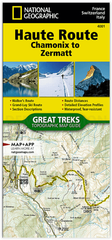
Wandelkaart 4001 Haute Route - Chamonix to Zermatt - Nat Geo
Haute Route from Chamonix France to Zermatt Switzerland
Korte omschrijving
Haute Route - Chamonix to Zermatt - Nat Geo Productomschrijving: De Haute Route - ook wel de Hoge Route of Bergbeklimmersroute genoemd - doorkruist de Franse en Zwitserse Alpen. De route wer...

Specificaties
- Uitgever: National Geographic
- ISBN-13: 9781566958103
- HOOFDCATEGORIEËN: Wandelkaart
- Activiteiten: Wandelen, Hiking & Trekking
- Regio: Haute-S'avoie, Frankrijk, Valle d’Aosta, Italië, Wallis
- Land: Frankrijk, Italië, Zwitserland
- Schaal: 1:40000
- Afmeting: 11x24
- Taal: Engels
Volledige omschrijving
Haute Route - Chamonix to Zermatt - Nat Geo
Productomschrijving: De Haute Route - ook wel de Hoge Route of Bergbeklimmersroute genoemd - doorkruist de Franse en Zwitserse Alpen. De route werd halverwege de negentiende eeuw door leden van de Engelse Alpine Club bedacht als een zomerbergbeklimmersroute. Hoewel oorspronkelijk "The High-Level Route" genoemd door leden van de Alpine Club, legde een groep in 1911 voor het eerst met succes een winterroute van Bourg St. Pierre naar Zermatt op ski's aan en daarna werd de naam van de route in het Frans vertaald.
Als gevolg van hun succes, bleef de Franse term hangen, en de tocht kreeg een reputatie onder skiërs en ski-bergbeklimmers als een klassieke must-do winter / voorjaar tour. Er is ook een niet-technische Walker's Haute Route die aan populariteit heeft gewonnen en een klassieker op zich is geworden.
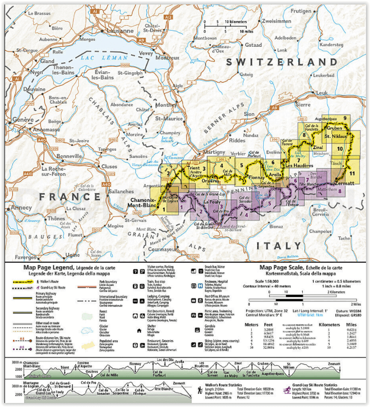
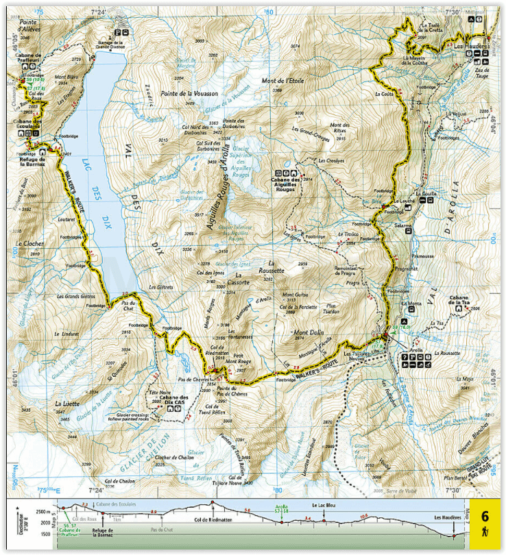
Deze Topografische Kaart Gids schetst twee verschillende varianten van de Haute Route van Chamonix, Frankrijk naar Zermatt, Zwitserland, een voor wandelaars en een voor skiërs. De meest noordelijke route of, Walker's Route, afgebeeld op de kaart reist noordwaarts van Chamonix en doorkruist de Alpen helemaal tot Zermatt. De skiroute die op deze kaart is afgebeeld, illustreert de Grand Lui variant, de langste en meest technische route die de wegverbindingen van de Verbier en Classic varianten elimineert.
Engelse omschrijving: The Haute Route—aka the High Route or Mountaineers' Route—traverses the French and Swiss Alps. It was conceived as a summer mountaineering route in the mid-nineteenth century by members of the English Alpine Club. Though originally called "The High-Level Route" by members of the Alpine Club, in 1911, a group first successfully established a winter route from Bourg St. Pierre to Zermatt on skis and afterwards the name of the route was translated into French. As a result of their success, the French term stuck, and the journey gained a reputation amid skiers and ski mountaineers as a classic must-do winter/spring tour. There is also a non-technical Walker's Haute Route that has gained in popularity and become a classic in and of itself.
This Topographic Map Guide outlines two different variations of the Haute Route from Chamonix, France to Zermatt, Switzerland, one for hikers and one for skiers. The northernmost route or, Walker's Route, depicted on the map travels north from Chamonix and traverses through the Alps all the way to Zermatt. The ski route depicted on this map illustrates the Grand Lui variation, which is the longest and most technical route that eliminates the road links of the Verbier and Classic variations.
Though the term Haute Route has been widely used for many multi-day, hut-to-hut alpine tours, the "Chamonix–Zermatt Haute Route" remains the original. Thus, whether you choose to wear skis or hiking boots, the Haute Route is an adventure unlike any other.
More convenient and easier to use than folded maps, but just as compact and lightweight, National Geographic’s Topographic Map Guide booklets are printed on "Backcountry Tough" waterproof, tear-resistant paper with stainless steel staples. A full UTM grid is printed on the map to aid with GPS navigation.
Artikelen uit dezelfde regio
Klimgids & Kletterführer Oberwallis - SAC • 9783859023109
Klimgids & Kletterführer Oberwallis Productomschrijving: 2000 routes in 99 klimgebieden: omringd door de hoogste bergen van Zwitserland, presenteert een zeer veelzijdig klim landschap met meer dan 250 multi pitch routes tot een lengte van 800 m. 2000 traject in 99 klimgebieden: worden hier gepresenteerd in een ongelooflijk divers klim landschap gelegen in het midden van de hoogste bergen v…

Wandelkaart 87 Breuil- Cervinia & Zermatt - Kompass • 9783990444252
Wandelkaart Breuil- Cervinia & Zermatt - Kompass Productomschrijving: De stad Breuil-Cervinia is een van de Italiaanse gemeente Valtournenche in de autonome regio Valle d'Aosta, Breuil is de Franse en Cervinia (na de Matterhorn) de Italiaanse naam van de plaats. De regio staat eerder bekend als Zermatt, het Zwitserse prachtige skigebied, die in de zomer diendt als wandelparadijs, in de sch…

Wandelgids Valais walking guide - Cicerone • 9781852847333
Wandelgids - Valais walking guide - Cicerone Productomschrijving: Uitgebreide gids naar de Valais, Zwitserland, met een beschrijving van 111 dagwandelingen en 10 meerdaagse routes. Een aantal van Europa's meest dramatische bergen vindt u hier, met inbegrip van de Matterhorn, Monte Rosa, Dent Blanche en Grand Combin. Van gemakkelijk wandelingen tot het moeilijker werk over robuuste passes -…

Wandelkaart TOP75 032 Chaîne d'ravis - Massif des Bauges - IGN • 9782758531500
Wandelkaart Chaîne des Aravis - Massif des Bauges Productomschrijving: IGN TOP75 kaarten zijn op maat gemaakt voor liefhebbers van outdoor activiteiten en liefhebbers van het culturele en historische erfgoed van onze regio's. De Aravis is een bergketen in de Pre-Alpen op de grens tussen de Haute-Savoie (westzijde), en een groot deel van de Savoie (oostzijde). De hoogste top is de piek Door…
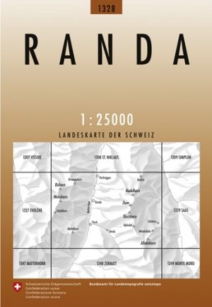

Wandelkaart 1328 - Randa Wallis Zwitserland - Swisstopo • 9783302013282
Wandelkaart Randa - Wallis Zwitserland - Swisstopo Productomschrijving: Kaart 1328 - De Europahütte omg. van het Zermatt skistation, gelegen aan de voet van het Wildwald dicht bij de Monte Rosa en de Matterhorn. Detail: Zeer gedetailleerde topografische kaarten & wandelkaarten van een klein stuke Zwitserland met schaal 1:25.000.en nr 1011 > 1374. De topografische details van deze kaart…