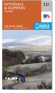
Wandelkaart 321 Nithsdale Schotland - OSI
Omvat Dumfries tot Thornhill en staat bekend als Nithsdale
Korte omschrijving
Wandelkaart Nithsdale - Dumfries & Galloway Schotland Omvat ook: Thornhill. Productbeschrijving: OS Explorer kaart 321 omvat Dumfries tot Thornhill. Het gebied staat bekend als Nithsdale...

Specificaties
- Uitgever: Ordnance Survey
- ISBN-13: 9780319471937
- HOOFDCATEGORIEËN: Wandelkaart
- Activiteiten: Wandelen, Hiking & Trekking
- Regio: Dumfries & Galloway, Schotland
- Land: Schotland
- Waterafstotende kaart: Ordnance Survey ACTIVE Explorer Weatherproof Maps
- Schaal: 1:25000
- Afmeting: 13x24
- Taal: Engels
- Reeks: Explorer ACTIVE Series OSI
Volledige omschrijving
Wandelkaart Nithsdale - Dumfries & Galloway Schotland
Omvat ook: Thornhill.
Productbeschrijving: OS Explorer kaart 321 omvat Dumfries tot Thornhill. Het gebied staat bekend als Nithsdale, want het is de vallei van de rivier de Nith. De indrukwekkende Drumlanrig Castle is het hele jaar door geopend, en er zijn wandelpaden in en rond het Nithsdale gebied. De OS Explorer kaart voor Nithsdale & Dumfries is beschikbaar in zowel de standaard papieren versie als de weerbestendige 'Actief' versie.
Productdiscription: OS Explorer map 321 covers Dumfries to Thornhill. The area is known as Nithsdale, as it's the valley of the River Nith. The impressive Drumlanrig Castle is open year round, or there are footpaths across the Nithsdale area. The OS Explorer map for Nithsdale & Dumfries is available in both the standard paper version and weatherproof 'Active' version.
Locatie op kaart
Gekoppelde artikelen

Wandelkaart 321 Nithsdale & Dumfries & Thornhill - OSI • 9780319245736
standaard versieWandelkaart Nithsdale & Dumfries - Thornhill Dumfries Omvat ook: Thornhill Productomschrijving: OS Explorer kaart 321 omvat Dumfries te Thornhill. Het gebied staat bekend als Nithsdale, want het is de vallei van de rivier de Nith. De indrukwekkende Drumlanrig Castle is het hele jaar geopend, of er zijn wandelpaden over het Nithsdale gebied. De OS Explorer kaart voor Nithsdale & Dumfrie…

Wandelkaart 321 Nithsdale Schotland - OSI • 9780319471937
weatherproof versieWandelkaart Nithsdale - Dumfries & Galloway Schotland Omvat ook: Thornhill. Productbeschrijving: OS Explorer kaart 321 omvat Dumfries tot Thornhill. Het gebied staat bekend als Nithsdale, want het is de vallei van de rivier de Nith. De indrukwekkende Drumlanrig Castle is het hele jaar door geopend, en er zijn wandelpaden in en rond het Nithsdale gebied. De OS Explorer kaart voor Nithsd…
Artikelen uit dezelfde regio

Wandelkaart 318 Galloway Forest Park North - OSI • 9780319471906
Wandelkaart Galloway Forest Park North - Schotland Omvat ook: Glen Trool & Loch Doon St John’s Town of Dalry. Productbeschrijving: OS Explorer kaart nummer 318 toont het noordelijk deel van het Gallowway Forest Park, Doon Loch, Loch Trool, de Southern Upland Way en de E2 Europese Long Distance pad. De OS Explorer kaart voor Galloway Forest Park North is beschikbaar in zowel de standaar…

Wandelkaart XT25 Galloway Hills Schotland - Harvey Maps • 9781851376070
Wandelkaart Galloway Hills Schotland Productomschrijving: Ervaar de voldoening van het navigeren met de Superwalker XT25 kaarten, nu gedrukt op 100% waterbestendig en bijna onverwoestbaar papier, bij gelijk welk weer! - De kaart representeert de Galloway Hills in Schotlands regio Dumfries & Galloway. Het gebied staat bekend voor zijn bosrijke landschappen, en zijn prachtige natuur. Det…

Wandelkaart 309 Stranraer & The Rhins Dumfries - OSI • 9780319245613
Wandelkaart Stranraer & The Rhins - Dumfries & Galloway Productbeschrijving: Kaart nummer 309 omvat Stranraer en The Rhins. Hoogtepunten zijn onder andere kasteel Kennedy, Loch Ryan en Luce Bay. Bevat ook delen van de Southern Upland Way (E2 Europese Long Distance pad), Penwhirn Reservoir, Stoneykirk en Port Logan. De OS Explorer kaart voor Stranraer & The Rhins is beschikbaar in zowel de …

Wandelkaart 313 Dumfries & Dalbeattie- Schotland - OSI • 9780319245651
Wandelkaart Dumfries & Dalbeattie - Schotland Productbeschrijving: New Abbey & Mabie Forest. 313 / Dumfries & Dalbeattie, Dumfries & Galloway, Schotland - Kaart nummer 313 omvat Dumfries en Tokaj. Hoogtepunten zijn Nith estuarium en Stewarty oostkust. Omvat ook Mabie Forest, Milton Loch, Urr Water en Maidenpap. De OS Explorer kaart voor Dumfries & Tokaj is beschikbaar in zowel de stan…

Wandelkaart 330 Moffat & St Mary's Loch Schotland - OSI • 9780319472026
Wandelkaart Moffat & St Mary's Loch - Schotland Omvat ook: Megget Reservoir. Productbeschrijving: OS Explorer kaart nummer 330 toont St. Mary's Loch, Megget, die betrekking heeft op Moffat in Dumfries and Galloway, de Reservoir en deel van de Southern Upland Way lange afstand wandelroute. De OS Explorer kaart voor Moffat & St Mary's Loch is beschikbaar in zowel de standaard papieren ve…


