
Wandelkaart 177 East London & Billericay- England - OSI
Gravesend & Tilbury Docks in het oosten tot London

Korte omschrijving
Wandelkaart East London- Billericay & Gravesend - England Productbeschrijving: De OS Landranger kaarten reeks heeft betrekking op Groot-Brittannië met 204 gedetailleerde kaarten, perfect voo...

Specificaties
- Uitgever: Ordnance Survey
- ISBN-13: 9780319475003
- HOOFDCATEGORIEËN: Wandelkaart
- Activiteiten: Wandelen, Hiking & Trekking
- Regio: Greater London, England
- Land: England
- Waterafstotende kaart: Ordnance Survey ACTIVE Landranger Weatherproof Maps
- Schaal: 1:50000
- Afmeting: 13x23
- Taal: Engels
- Reeks: Landranger ACTIVE series OSI
Volledige omschrijving
Wandelkaart East London- Billericay & Gravesend - England
Productbeschrijving: De OS Landranger kaarten reeks heeft betrekking op Groot-Brittannië met 204 gedetailleerde kaarten, perfect voor dagtochten en korte pauzes. Elke kaart bevat alle informatie die u nodig heeft om dit lokaal gebied te leren kennen en omvat plaatsen van belang, toeristische informatie, picknickplaatsen en campings, plus doorgangsrechten informatie voor Engeland en Wales.
Productdiscription: The OS Landranger Map series covers Great Britain with 204 detailed maps, perfect for day trips and short breaks. Each map provides all the information you need to get to know your local area and includes places of interest, tourist information, picnic areas and camp sites, plus Rights of Way information for England and Wales.
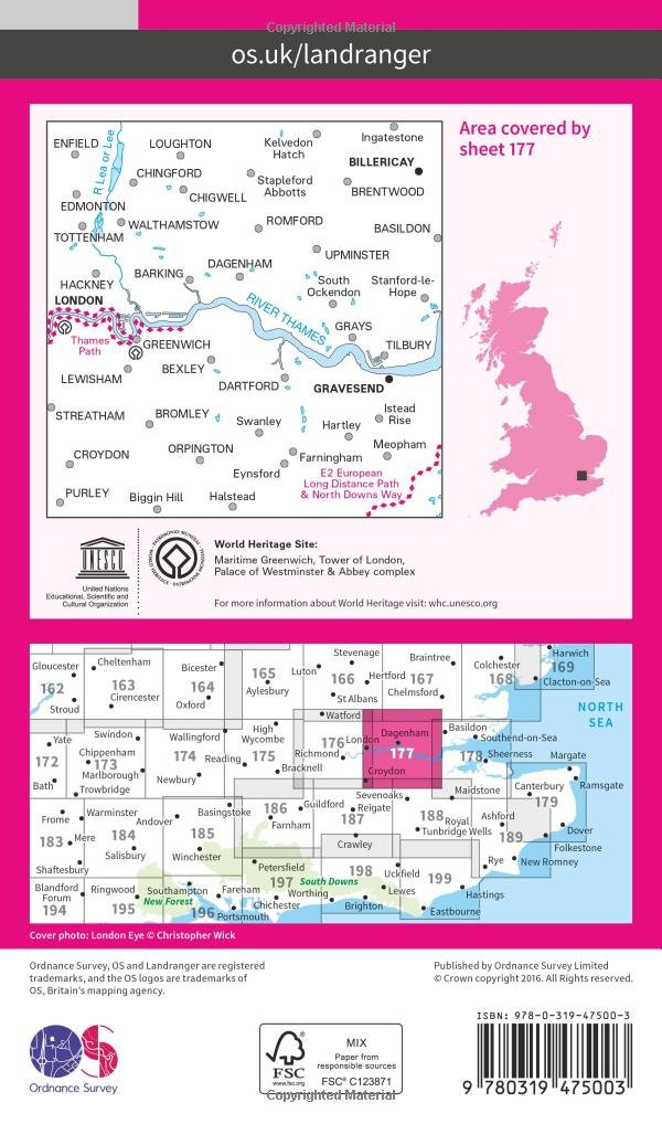
Map sheet number 177 in the OS Landranger map series covers East London. The area covered extends from Gravesend and Tilbury Docks in the east to central London. The map gives visitors a detailed overview of the city from central areas to the suburban towns of Chingford, Enfield, Billericay, Croydon and Bromley. Highlights of the area include: the River Thames, Greenwich Village, Docklands and the westernmost section of the Thames Path.
Locatie op kaart
Artikelen uit dezelfde regio

Reisgids Week-end Londen England - Michelin Lannoo • 9789401489157
Weekendje Londen England - Michelin Productomschrijving: De bewezen sterrenquotering zorgt ervoor dat je geen enkele topper mist - Met tientallen geteste adressen om te overnachten, een hapje te eten, een glas te drinken, een avond te genieten of te shoppen - Alle adressen zijn op een uitneembare stadsplattegrond aangeduid: met een duidelijk herkenbare kleur voor iedere categorie

Wandelkaart 162 Greenwich & Gravesend - OSI • 9780319243558
Wandelkaart Greenwich & Gravesend - Greater London Omvat ook: East End, Docklands, Bromley, Sidcup & Thurrock Productomschrijving: Kaart nummer 162 in de OS Explorer kaarten reeks beslaat een gebied naar het oosten van Londen van Greenwich tot Gravesend. Hoogtepunten van het gebied zijn onder andere: Thames Path, Thames Chase community Forest, Darent Valley paat, Capiral-Ring, Londen l…

Wandelkaart 176 West London & Rickmansworth - OSI • 9780319262740
Wandelkaart West London- Rickmansworth - London England Productbeschrijving: Kaart nummer 176 in de OS Landranger kaarten reeks, is een grote kaart voor de planning dagexcursies in West-Londen. Het gebied strekt zich uit van Windsor en Slough in het westen naar centraal Londen, Islington en kan bezoekers om te verkennen van een groot gebied omvat een groot deel van de stad en het omliggend…

Reisgids Londres en quelques jours - Lonely Planet • 9782816171051
Reisgids Londres en quelques jours - Lonely Planet Déscription de produits: Toutes les clés pour découvrir Londres le temps d'un week-end Le meilleur de Londres en un clin d'œil: tous les sites majeurs décryptés et des conseils d'expert pour tirer le meilleur parti de ses visites. Des doubles pages détaillées sur les sites londoniens incontournables: la Tour de Londres, le British Mus…

Wandelkaart 174 Epping Forest & Lee Valley- London - OSI • 9780319470466
Wandelkaart Epping Forest & Lee Valley - London England Omvat ook: Hertford & Harlow. Productbeschrijving: Kaart nummer 174 in de OS Explorer reeks omvat Epping Forest en het gebied naar het Noord Oosten van Londen. Het besproken gebied van de kaart omvat Hertford en Harlow in het noorden tot Ilford en Tottenham naar het zuiden, en omvat hoogtepunten zoals Epping Forest, Centenary way,…