
Wandelkaart 133 North East Norfolk - OSI
Cromer - Holt - North Walsham - Aylsham - Sherringham & Wroxham
Korte omschrijving
Wandelkaart North East Norfolk - OSI Productomschrijving: Kaart nummer 133 in de OS Landranger kaartenserie bestrijkt het noordoosten van Norfolk, Cromer, Holt, North Walsham, Aylsham, Sherr...

Specificaties
- Uitgever: Ordnance Survey
- ISBN-13: 9780319263563
- HOOFDCATEGORIEËN: Wandelkaart
- Activiteiten: Wandelen, Hiking & Trekking
- Regio: Norfolk East England
- Land: England
- Lange afstand wandelroutes: Peddars Way & Norfolk Coast Path (135 km)
- Schaal: 1:50000
- Afmeting: 13x23
- Taal: Engels
- Reeks: Landranger Series OSI
Volledige omschrijving
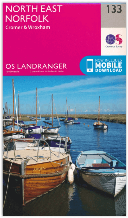
Wandelkaart North East Norfolk - OSI
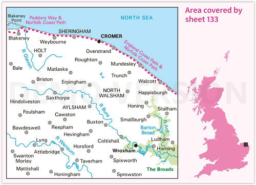
Productomschrijving: Kaart nummer 133 in de OS Landranger kaartenserie bestrijkt het noordoosten van Norfolk, Cromer, Holt, North Walsham, Aylsham, Sherringham en Wroxham en omvat Barton Broad en het zuidelijkste deel van de Peddars Way & Norfolk Coast Path. De kaart bestrijkt een gebied van 40 km bij 40 km (25 mijl bij 25 mijl).
Engelse omschrijving: Map sheet number 133 in the OS Landranger map series covers north east Norfolk, Cromer, Holt, North Walsham, Aylsham, Sherringham and Wroxham and includes Barton Broad and the southernmost section of the Peddars Way & Norfolk Coast Path. The map covers an area of 40 km by 40 km (25 miles by 25 miles).
Locatie op kaart
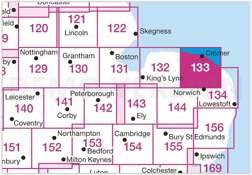
Overzichtskaarten

OSI Landranger & Landranger Active - Midden Engeland - Midland's
OSI Landranger & Landranger Active - Midden Engeland - Midland's

Producten op de overzichtskaart
Klik op een product om naar de detailpagina te gaan.
- Wandelkaart 156 Saxmundham & Aldeburgh - OSI
- Wandelkaart 156 Saxmundham- Aldeburgh & Southwold - OSI
- Wandelkaart 157 St-David's & Haverfordwest - Wales - OSI
- Wandelkaart 157 St-David's & Haverfordwest - Wales - OSI
- Wandelkaart 158 Tenby & Pembroke - Wales - OSI
- Wandelkaart 158 Tenby & Pembroke - Wales - OSI
- Wandelkaart 159 Swansea & Gower - South Wales - OSI
- Wandelkaart 159 Swansea- Gower & Carmarthen - OSI
- Wandelkaart 160 Brecon Beacons NP - Powys Wales - OSI
- Wandelkaart 160 Brecon Beacons NP - Powys Wales - OSI
- Wandelkaart 161Black Mountains & Brecon Beacons NP - OSI
- Wandelkaart 161Black Mountains & Brecon Beacons NP - OSI
- Wandelkaart 163 Cheltenham & Cirencester - England - OSI
- Wandelkaart 163 Cheltenham & Cirencester - England - OSI
- Wandelkaart 162 Gloucester & Forest of Dean - OSI
- Wandelkaart 164 Oxford & Chipping Norton - England - OSI
- Wandelkaart 164 Oxford & Chipping Norton - England - OSI
- Wandelkaart 165 Aylesbury & Leighton Buzzard - OSI
- Wandelkaart 165 Aylesbury & Leighton Buzzard - OSI
- Wandelkaart 166 Luton- Hertford & Hitchin - OSI
- Wandelkaart 166 Luton- Hertford & Hitchin- Bedfordshire - OSI
- Wandelkaart 167 Chelmsford & Harlow- Essex England - OSI
- Wandelkaart 167 Chelmsford- Harlow & Bishop's - OSI
- Wandelkaart 168 Colchester- Halstead & Maldon - OSI
- Wandelkaart 168 Colchester- Halstead & Maldon- England - OSI
- Wandelkaart 169 Ipswich & The Naze- England - OSI
- Wandelkaart 169 Ipswich & The Naze- England - OSI
- Wandelkaart 145 Cardigan & Mynydd Preseli - OSI
- Wandelkaart 145 Cardigan & Mynydd Preseli - OSI
- Wandelkaart 146 Lampeter & Llandovery - Ceredigion - OSI
- Wandelkaart 146 Lampeter & Llandovery - Ceredigion - OSI
- Wandelkaart 147 Elan Valley & Builth Wells - Wales - OSI
- Wandelkaart 147 Elan valley & Builth Wells - Wales - OSI
- Wandelkaart 148 Presteigne & Hay-on-Wye - S. Wales - OSI
- Wandelkaart 148 Presteigne & Hay-on-Wye - S. Wales - OSI
- Wandelkaart 149 Hereford & Leominster - England - OSI
- Wandelkaart 149 Hereford & Leominster - England - OSI
- Wandelkaart 150 Worcester & The Malverns - England - OSI
- Wandelkaart 150 Worcester & The Malverns - England - OSI
- Wandelkaart 151 Stratford-upon-Avon & Warwick - OSI
- Wandelkaart 151 Stratford-upon-Avon- England - OSI
- Wandelkaart 152 Northampton & Milton Keynes - OSI
- Wandelkaart 152 Northampton & Milton Keynes - OSI
- Wandelkaart 153 Bedford & Huntingdon- England - OSI
- Wandelkaart 153 Bedford- Huntingdon & St-Neots - OSI
- Wandelkaart 154 Cambridge & Newmarket - England - OSI
- Wandelkaart 154 Cambridge & Newmarket - England - OSI
- Wandelkaart 155 Bury St-Edmunds & Stowmarket - OSI
- Wandelkaart 155 Bury St-Edmunds & Sudbury - OSI
- Wandelkaart 135 Aberystwyth & Machynlleth Wales - OSI
- Wandelkaart 135 Aberystwyth & Machynlleth Wales - OSI
- Wandelkaart 137 Ludlow & Church Stretton - England - OSI
- Wandelkaart 137 Ludlow & Church Stretton - England - OSI
- Wandelkaart 138 Kidderminster & Wyre Forest - OSI
- Wandelkaart 138 Kidderminster & Wyre Forest - OSI
- Wandelkaart 139 Birmingham & Wolverhampton - OSI
- Wandelkaart 139 Birmingham & Wolverhampton - OSI
- Wandelkaart 140 Leicester- Coventry & Rugby - OSI
- Wandelkaart 140 Leicester- Coventry & Rugby - OSI
- Wandelkaart 140 Kettering & Corby- England - OSI
- Wandelkaart 141 Kettering & Corby- England - OSI
- Wandelkaart 142 Peterborough & Market Deeping - England
- Wandelkaart 142 Peterborough & Market Deeping- England
- Wandelkaart 143 Ely & Wisbech- Cambridgeshire - OSI
- Wandelkaart 143 Ely- Wisbech & Downham - OSI
- Wandelkaart 144 Thetford & Breckland- Norfolk - OSI
- Wandelkaart 144 Thetford- Breckland & Wymondham - OSI
- Wandelkaart 124 Porthmadog & Dolgellau - N. Wales - OSI
- Wandelkaart 124 Porthmadog & Dolgellau - N. Wales - OSI
- Wandelkaart 125 Bala & Lake Vyrnwy- Gwynedd - OSI
- Wandelkaart 125 Bala & Lake Vyrnwy- N. Wales - OSI
- Wandelkaart 126 Shrewsbury & Oswestry - England - OSI
- Wandelkaart 126 Shrewsbury & Oswestry - England - OSI
- Wandelkaart 127 Stafford & Telford - Ironbridge England - OSI
- Wandelkaart 127 Stafford & Telford - Staffordshire England - OSI
- Wandelkaart 128 Derby & Burton upon Trent - England - OSI
- Wandelkaart 128 Derby & Burton upon Trent - England - OSI
- Wandelkaart 129 Nottingham & Loughborough - England - OSI
- Wandelkaart 129 Nottingham & Loughborough - England - OSI
- Wandelkaart 130 Grantham- Lincolnshire- England - OSI
- Wandelkaart 130 Grantham- Sleaford & Bourne - OSI
- Wandelkaart 131 Boston & Spalding - England - OSI
- Wandelkaart 131 Boston & Spalding - Lincolshire England - OSI
- Wandelkaart 132 King's Lynn & Fakenham - England - OSI
- Wandelkaart 114 Anglesey & Ynys Môn- N.W. Wales - OSI
- Wandelkaart 114 Anglesey- North West Wales - OSI
- Wandelkaart 115 Snowdon & Caernarfon- Snowdonia NP - OSI
- Wandelkaart 115 Snowdon & Yr Wyddfa - Snowdonia NP - OSI
- Wandelkaart 116 Denbigh & Colwyn Bay - North Wales - OSI
- Wandelkaart 116 Denbigh & Colwyn Bay - North Wales - OSI
- Wandelkaart 117 Chester & Wrexham - Ellesmere Port - OSI
- Wandelkaart 117 Chester & Wrexham - West Cheshire - OSI
- Wandelkaart 118 Stoke-on-Trent & Macclesfield - OSI
- Wandelkaart 118 Stoke-on-Trent & Macclesfield - OSI
- Wandelkaart 119 Buxton & Matlock- Derbyshire - OSI
- Wandelkaart 119 Buxton- Matlock & Chesterfield - OSI
- Wandelkaart 120 Mansfield - Nottinghamshire - OSI
- Wandelkaart 120 Mansfield & Sherwood Forest - OSI
- Wandelkaart 121 Lincoln & Newark-on-Trent- England - OSI
- Wandelkaart 121 Lincoln & Newark-on-Trent- England - OSI
- Wandelkaart 122 Skegness & Horncastle - England - OSI
- Wandelkaart 122 Skegness & Horncastle - England - OSI
- Wandelkaart 123 Lleyn Peninsula - North Wales - OSI
- Wandelkaart 123 Lleyn Peninsula - North Wales - OSI
- Wandelkaart 108 Liverpool & Southport - England - OSI
- Wandelkaart 108 Liverpool & Merseyside - England - OSI
- Wandelkaart 109 Greater Manchester England - OSI
- Wandelkaart 109 Manchester- Bolton & Warrington - OSI
- Wandelkaart 110 Sheffield & Huddersfield - Glossop - OSI
- Wandelkaart 110 Sheffield & Huddersfield - Yorkshire - OSI
- Wandelkaart 111 Sheffield & Doncaster- Rotherham - OSI
- Wandelkaart 111 Sheffield & Doncaster England - OSI
- Wandelkaart 112 Scunthorpe & Gainsborough - OSI
- Wandelkaart 112 Scunthorpe & Gainsborough - OSI
- Wandelkaart 113 Grimsby- Louth & Market Rasen - OSI
- Wandelkaart 113 Grimsby- North East Lincolnshire - OSI
- Wandelkaart 102 Preston & Blackpool- Lancashire - OSI
- Wandelkaart 102 Preston & Blackpool- Lytham - OSI
- Wandelkaart 103 Blackburn & Burnley- N.W. England - OSI
- Wandelkaart 103 Blackburn- Burnley & Clitheroe - OSI
- Wandelkaart 104 Leeds & Bradford & Harrogate - OSI
- Wandelkaart 104 Leeds & Bradford - West Yorkshire - OSI
- Wandelkaart 105 York & Selby- North Yorkshire - OSI
- Wandelkaart 105 York & Selby- North Yorkshire - OSI
- Wandelkaart 106 Market Weighton- East Riding of Yorkshire - OSI
- Wandelkaart 106 Market Weighton- Goole- England - OSI
- Wandelkaart 107 Kingston upon Hull- Beverley - OSI
- Wandelkaart 107 Kingston upon Hull- Yorkshire - OSI
- Wandelkaart 133 North East Norfolk - OSI
- Wandelkaart 133 North East Norfolk - Cromer - Wroxham - OSI
- Wandelkaart 134 Norwich & The Broads NP - OSI
- Wandelkaart 134 Norwich- The Broads NP & Great Yarmouth - OSI
Artikelen uit dezelfde regio

Reisgids Go Slow - Norfolk - Bradt Travel Guides • 9781804690116
Reisgids Norfolk England - Bradt Travel Guides Productomschrijving: Deze nieuwe, grondig bijgewerkte 2e editie van Bradt's Norfolk, onderdeel van de kenmerkende 'Slow travel' serie van gidsen over de Britse regio's, blijft de enige volledige zelfstandige gids beschikbaar voor dit land van contrasten, van de mooie middeleeuwse stad Norwich tot de waterige wildernis van de Broads en de prach…

Wandelkaart 132 King's Lynn & Fakenham England - OSI • 9780319474556
Wandelkaart North West Norfolk- King's Lynn & Fakenham Productbeschrijving: Kaart nummer 132 in de OS Landranger kaarten reeks heeft de oppervlakte van Noord west Norfolk, King's lynn, Wells-Next-The-Sea, Fakenham, Hunstanton, Dereham en Holmes volgende de zee. Andere hoogtepunten van het gebied: de Peddars Way & Norfolk Coast Path, Holkham Bay, Brancaster Bay en The Wash. De OS Landra…

Wandelkaart 237 Norwich & Wymondham- Norfolk - OSI • 9780319244302
Wandelkaart Norwich & Wymondham - Norfolk England Omvat ook: Wymondham, Attleborough & Watton Productomschrijving: De hoofdstad van Norfolk, Norwich is een uitstekende uitvalsbasis voor het verkennen van de provincie. Er zijn tal van opties voor activiteiten op OS Explorer kaart 237 voor het hele gezin, terwijl u wat wandelen betreft, van Boudicca tot Tas vallei way kunt gaan verkennen…

Fietskaart Norfolk - Goldeneye • 9781859652923
Fietskaart Norfolk - Goldeneye Productomschrijving: Norfolk is het op drie na grootste graafschap van Engeland en een van de meest landelijke. Het is ook een van de vlakste en onze cirkelroutes zijn gekozen om de rustige wegen te verkennen die de afgelegen en pittoreske dorpjes en bezienswaardigheden met elkaar verbinden. Dit is ideaal fietsgebied en gelukkig zet de Norfolk County Council …

Reisgids Norfolk & Suffolk - Rough Guides • 9781839050749
Norfolk & Suffolk - Rough Guides Productomschrijving: De Rough Guide to Norfolk & Suffolk richt zich op een van de meest populaire regio's van het Verenigd Koninkrijk. In full colour, met tientallen prachtige foto's, zal het u inspireren om dit diverse en prachtige gebied te verkennen. Levendige, onderhoudende verslagen in de kenmerkende eerlijke, openhartige stijl van de Rough Guides…