
Wandelgids Walking the Munros Vol 1 - Cicerone Press
69 challenging routes across Glencoe- Bridge of Orchy and Mull


Korte omschrijving
Walking the Munros Vol 1 - Cicerone Productomschrijving: Wandelgids over de Munros in de zuidelijke, centrale en westelijke Highland's. De gids beschrijft 69 uitdagende routes over 139 van d...

Specificaties
- Uitgever: CICERONE Press
- ISBN-13: 9781786311054
- HOOFDCATEGORIEËN: Wandelgids
- Activiteiten: Wandelen, Hiking & Trekking
- Auteur: Steve Kew
- Regio: Highlands, Schotland
- Land: Schotland
- Blz.: 272
- Afmeting: 12x17
- Editie: 4
- Taal: Engels
Volledige omschrijving
Walking the Munros Vol 1 - Cicerone
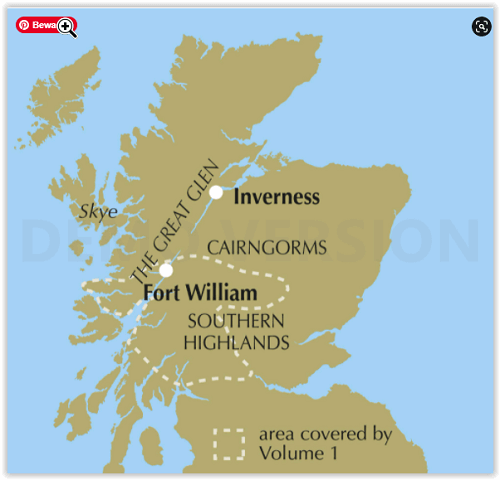
Productomschrijving: Wandelgids over de Munros in de zuidelijke, centrale en westelijke Highland's. De gids beschrijft 69 uitdagende routes over 139 van de meest iconische 3000f+ bergen in gebieden zoals Glencoe, Bridge of Orchy en Mull. Inclusief routes op Ben More, Ben Alder, Ben Lomond en Ben Nevis, de hoogste berg van de Britse eilanden. Deel 1 van twee reisgidsen.
Engelse omschrijving: Guidebook to walking the Munros in southern, central and western Highlands. Describes 69 challenging routes across 139 of the iconic 3000ft+ mountains covering areas such as Glencoe, Bridge of Orchy and Mull. Includes routes up Ben More, Ben Alder, Ben Lomond and Ben Nevis, the highest mountain in the British Isles. Volume 1 of two guidebooks.
Seasons:
Year-round mountain walking, with summer walking in mind. However, midges may hold you back in summer, and if snow's not your thing then avoid winter.
Centres:
Fort William, Glencoe, Killin, Pitlochry, Blair Atholl, Oban and many more.
Difficulty:
Many Munros are straightforward walks, but some have exciting ridge walking and scrambling. Aonach Eagach is covered in this volume. Normal Scottish mountain challenges and precautions.
Must See:
The extroardinary beauty of Scotland's mountain landscape; the challenge of a long and strenuous climb; the achievement of the summit; the sight of wilderness stretching out for miles around; the tidal wave of cloud flowing over a ridge; the sweet peace of that first refreshment at the end of the day.
Locatie op kaart
Artikelen uit dezelfde regio

Wandelkaart 413 Knoydart Loch Houm Schotland - OSI • 9780319472682
Wandelkaart Knoydart- Loch Houm - Highland's Schotland Omvat ook: Kyle of Lochalsh. Productbeschrijving: Explorer kaart 413 omvat de regio Kyle of Lochalsh tot Inverie, deze ruige kustlijn nodigt u uit voor ontdekking. Met 4 van de Munros en diverse andere belangrijke toppen, naast twee nationale natuurgebieden is het een populaire regio voor het ondekken van de schotse hooglanden. De …

Wandelkaart 16 Lairg & Loch Shin Highland's Schotland - OSI • 9780319261149
Wandelkaart Lairg & Loch Shin - Highland's Schotland Productbeschrijving: OS Landranger kaart 16 toont het gebied rondom Loch Shin en Loch Naver, met inbegrip van Lairg en Oykel Bridge. Er valt ook een fietsroute langs de schilderachtige A836 te vinden, of u kunt een bezoek brengen aan de watervallen van Shin. De OS Landranger kaarten reeks heeft betrekking op Groot-Brittannië met 204…

Wandelkaart 429 Glen Carron & West Monar- Schotland - OSI • 9780319246610
Wandelkaart Glen Carron & West Monar - Lanarkshire Schotland Productbeschrijving: Strathcarron & Attadale Forest. 429 / Glen Carron & West Monar, Lanarkshire, Schotland - Kaart nummer 429 omvat Glen Carron en West Monar. Hoogtepunten zijn Attadale Forest, Strathcarron en Loch Dùghaill. Omvat ook Carn Breac, Loch Sgamhain, Ben Killilan en Achnashellach. De OS Explorer kaart voor Glen Ca…

Wandelkaart 442 Assynt & Lochinver Schotland - OSI • 9780319246856
Wandelkaart Assynt & Lochinver - Highlands Schotland Productbeschrijving: Kylesku & Inchnadamp 442 / Assynt & Lochinver, Highlands Schotland - Van Kylesku tot Lochinver en The Minch, is het hele gebied aangewezen als National Scenic Area. Er zijn 2 Munro's is dit gebied - Ben More Assynt is 998m hoog. De OS Explorer kaart voor Assynt & Lochinver is beschikbaar in zowel de standaard pa…

Wandelkaart 383 Morvern & Lochaline- Schotland - OSI • 9780319472491
Wandelkaart Morvern & Lochaline- Highland Schotland Omvat ook: Kingairloch. Productbeschrijving: Kaart blad nummer 383 in de OS Explorer kaarten reeks omvat Morvern en Lochaline in de Schotse Hooglanden. Dit schilderachtige gebied beschikt over vele Lochs om te verkennen, met inbegrip van Loch Linnhe, Loch Aline en Loch Sunart samen met de Sound of Mull. De steden Kingairloch en Lochal…