
Wandelgids The Skye Trail - Cicerone Press
From Rubha Hunish to Broadford
Korte omschrijving
The Skye Trail - Cicerone Press Productomschrijving: Deze gids beschrijft The Skye Trail, een uitdagende tocht van een week over het grootste eiland in de Binnen-Hebriden van Schotland, het ...

Specificaties
- Uitgever: CICERONE Press
- ISBN-13: 9781786311863
- HOOFDCATEGORIEËN: Wandelgids
- Activiteiten: Wandelen, Hiking & Trekking
- Auteur: Helen Webster, Paul Webster
- Regio: Highlands Noord, Schotland, Isle of sky, Schotland
- Land: Schotland
- Blz.: 112
- Afmeting: 12x17
- Editie: 3
- Taal: Engels
Volledige omschrijving
The Skye Trail - Cicerone Press
Productomschrijving: Deze gids beschrijft The Skye Trail, een uitdagende tocht van een week over het grootste eiland in de Binnen-Hebriden van Schotland, het Isle of Skye. Vanaf Rubha Hunish in het noorden voert de Skye Trail langs de Trotternish Ridge en langs de Cuillin naar Broadford in het zuiden. Geschikt voor ervaren rugzaktrekkers en bergwandelaars.
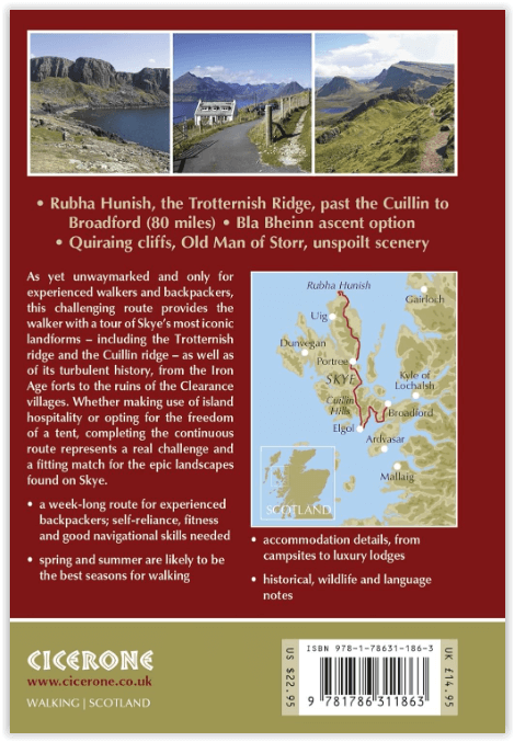
Engelse omschrijving: This guidebook describes The Skye Trail, a challenging week-long trek across the largest island in Scotland's Inner Hebrides, the Isle of Skye. From Rubha Hunish in the north, the Skye Trail heads along the Trotternish Ridge and past the Cuillin to Broadford in the south. Suitable for experienced backpackers and mountain walkers.
Seasons:
Spring and summer are likely to be the best months for walking on Skye, with early May being popular to avoid the midges; longer daylight hours also make it possible to cover large distances.
Centres:
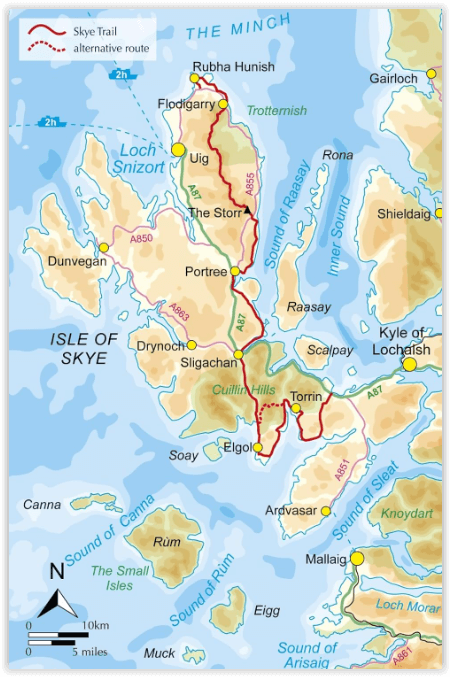
Begins at Rubha Hunish at the northern end of Skye; passes through the island capital - Portree - after three days; finishes at the large village of Broadford.
Difficulty:
A week-long route for experienced backpackers; self-reliance, fitness and good navigational skills will all be called upon.
Must See:
The stunning headland at Rubha Hunish, the Trotternish Ridge, the spectacular rock scenery of the Quiraing and the Old Man of Storr, picturesque Portree, walking in the shadow of the mighty Cuillin, the abandoned village of Boreraig.
Artikelen uit dezelfde regio

Wandelkaart 412 Sleat Isle of Skye Schotland - OSI • 9780319472675
Wandelkaart Sleat - Isle of Skye Schotland Omvat ook: Broadford, Kyleakin & Armadale. Productbeschrijving: Kaart nummer 412 omvat het eiland Skye. Hoogtepunten zijn de Cuillin Hills, Loch Eishort en Loch Slapin. Omvat ook Armadale / Armadail en Broadford / An t-Àth Leathann. De OS Explorer kaart voor Skye - Sleat is beschikbaar in zowel de standaard papieren versie als …

Wandelkaart 450 Wick & The Flow Country - OSI • 9780319246931
Wandelkaart Wick & The Flow Country - Northern Highland's Omvat ook: Lybster, Latheron & Dunbeath. Productbeschrijving: OS Explorer kaart 450 behandelt Wick en de Moray Firth, met inbegrip van Lybster, Latheron en Dunbeath. Wick bestaat al sinds ten minste 1266 en heeft 's werelds kortste straat, Ebenezer plaats. De Flow Country is een groot gebied van moerassig, laaggelegen land. De O…

Wandelkaart 15 Loch Assynt Northern Highland's- Schotland • 9780319473382
Wandelkaart Loch Assynt - Northern Highland's Schotland Productbeschrijving: Kaart nummer 15 in de reeks van de OS Landranger kaarten is de ideale kaart voor planning dagtrips en vakanties in de Noordwestelijke Highlands van Schotland. Ontdek de schoonheid van de vele lochs opgenomen in het gebied waaronder Loch Assynt en Loch More. Andere hoogtepunten zijn de steden van Lochinver, Kylesku…

Wandelkaart 407 Isle of Skye & Dunvegan Highland's - OSI • 9780319246429
Wandelkaart Isle of Skye & Dunvegan - Highland's Schotland Omvat ook: Waternish & Macleod’s Tables. Productbeschrijving: Kaart nummer 407 in de OS Explorer kaarten reeks is de perfecte kaart om te gebruiken bij het verkennen van "The Isle of Skye", Dunvegan, Waternish en de Macleod's tables. Het gebied is rijk aan geschiedenis en de perfecte plek om te genieten van kust wandelingen. Ho…

Wandelkaart 451 Thurso & John o' Groats - Schotland - OSI • 9780319246948
Wandelkaart Thurso & John o' Groats - Northern Highland's Omvat ook: Dunnet Head Productbeschrijving: OS Explorer kaart 451 toont het uiterste noord-oosten van Schotland. John o'Groats is technisch gezien niet het meest noordelijke dorp, maar dat houd het niet tegen om een belangrijke toeristische attractie te zijn. Thurso is een gemoedelijk dorp en een uitstekende uitvalsbasis in …