
Wandelgids The Great Glen Way 124 km - Rucksach Readers
Tussen Fort William en Inverness - 124 Kkm

Korte omschrijving
Wandelgids The Great Glen Way - Rucksach Readers Productomschrijving: De Great Glen Way is een van de Great Trails van Schotland en biedt een geweldige ervaring voor zowel wandelaars als fie...

Specificaties
- Uitgever: RUCKSACK READERS
- ISBN-13: 9781913817206
- HOOFDCATEGORIEËN: Wandelgids
- Activiteiten: Wandelen, Hiking & Trekking
- Auteur: Jacquetta Megarry, Sandra Bardwell
- Regio: Highlands, Schotland
- Land: Schotland
- Lange afstand wandelroutes: The Great Glen Way (124 km)
- Blz.: 80
- Schaal: 1:38000
- Afmeting: 13x22
- Editie: 7
- Taal: Engels
Volledige omschrijving
Wandelgids The Great Glen Way - Rucksach Readers
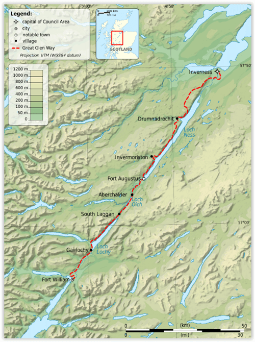
Productomschrijving: De Great Glen Way is een van de Great Trails van Schotland en biedt een geweldige ervaring voor zowel wandelaars als fietsers. De route loopt over een afstand van 77 mijl (124 km) langs de Great Glen van Schotland tussen Fort William en Inverness. De route volgt het schilderachtige Caledonisch Kanaal en loopt langs vier van de mooiste lochs van de Highlands - waaronder Loch Ness, beroemd om zijn monsterlegende en om Urquhart Castle. De route is uitgebreid met verschillende High Route-opties, waarvan de meest recente de Abriachan High Route uit 2024 is, die wandelaars naar een nieuw hoogtepunt brengt op 434 m.
Engelse omschrijving: The Great Glen Way is one of Scotland’s Great Trails and offers a superb experience for both walkers and cyclists. The Way runs for 77 miles (124 km) along Scotland’s Great Glen between Fort William and Inverness. It follows the scenic Caledonian Canal and runs beside four of the Highlands’ loveliest lochs – including Loch Ness, famous for its monster legend and for Urquhart Castle. The route has been enhanced with several High Route options, most recently the 2024 Abriachan High Route taking walkers to a new high point at 434 m/1425 ft.
This edition was revised in late April 2024 and covers several important route updates for 2024-25: the Invergarry link route is mandatory until Loch Oichside reopens in 2025, the Fort Augustus to Invermoriston High Route is closed until summer 2024 and the approach to Inverness has changed around Craig Dunain. See Route updates below for more detail. The book is in our slim pocket-friendly format, with perfect binding (glued and sewn) and still on rainproof paper.
This guidebook contains all you need to plan and enjoy the Great Glen Way – on foot or on a bike:
• detailed mapping on 13 pages at 1:38,000
• hill and mountain side-trips including Ben Nevis
• background on canal heritage, clan history and wildlife
• detailed description for each section walked from Fort William to Inverness
• summaries showing distance, terrain, food/drink stops and altitude profile
• planning information for walkers and cyclists
• town plans of Fort William and Inverness
• in full colour, with 100+ photos, many of them new
• rucksack-friendly and on rainproof paper.
Locatie op kaart
Artikelen uit dezelfde regio

Wandelkaart 442 Assynt & Lochinver Schotland - OSI • 9780319246856
Wandelkaart Assynt & Lochinver - Highlands Schotland Productbeschrijving: Kylesku & Inchnadamp 442 / Assynt & Lochinver, Highlands Schotland - Van Kylesku tot Lochinver en The Minch, is het hele gebied aangewezen als National Scenic Area. Er zijn 2 Munro's is dit gebied - Ben More Assynt is 998m hoog. De OS Explorer kaart voor Assynt & Lochinver is beschikbaar in zowel de standaard pa…

Wandelkaart 441 Lairg- Bonar Bridge & Golspie- Schotland • 9780319246849
Wandelkaart Lairg- Bonar Bridge & Golspie - Highland Schotland Productbeschrijving: Dornoch & Brora. Aan de Moray Firth toont OS Explorer kaart 441, Omvat de route van Brora naar Dornoch en het binnenland van Lairg te Bonar Bridge. Ga op verkenning rond Loch Fleet en Loch Brora of volg de rivier van Loch Shin naar Kyle of Sutherland. De OS Explorer kaart voor Lairg, Bonar Bridge & Gols…

Wandelkaart 443 Ben Kilbreck- Ben Armine - Schotland - OSI • 9780319246863
Wandelkaart Ben Kilbreck- Ben Armine - Highlands Schotland Productbeschrijving: 443 / Ben Kilbreck, Ben Armine, Highlands, Schotland - OS Explorer kaart blad 443 toont de Munro Meall nan Con, Ben Klibreck, Loch Choire en Loch Shin.Toegang via de A836 aan de westzijde van de kaart - alleen onopgemaakte sporen en voetpaden hulpen u verder. De OS Explorer kaart voor Ben Klibreck & Ben Arm…

Wandelkaart 440 Glen Cassley & Glen Oykel Schotland - OSI • 9780319246832
Wandelkaart Glen Cassley & Glen Oykel - Highland Schotland Productbeschrijving: 440 / Glen Cassley & Glen Oykel, Highland, Schotland - Omvat de centrale hooglanden, de OS Explorer kaart 440 omvat de streek rond Oykel Bridge en Loch Shin. De OS Explorer kaart voor Glen Cassley & Glen Oykel is beschikbaar in zowel de standaard papieren versie als de weerbestendige 'Actief' versie. 44…

Wandelkaart 385 Rannoch Moor & Ben Alder- Schotland - OSI • 9780319472514
Wandelkaart Rannoch Moor & Ben Alder - Loch Rannoch Schotland Omvat ook: Loch Rannoch. Productbeschrijving: Kaart nummer 385 omvat Rannoch Moor en Ben Alder. Hoogtepunten zijn Loch Rannoch, Loch Laidon en het Cairngorms National Park & Tay Forest Park. Omvat ook Blackwater Reservoir, Loch Ossian en Loch Eigheach. De OS Explorer kaart voor Rannoch Moor & Ben Alder is beschikbaar in zowe…