
Wandelgids The Cotswold Way - Cicerone
Chipping Campden to Bath - National Trail
Korte omschrijving
The Cotswold Way - Cicerone Productomschrijving: Wandelgids over de Cotswold Way Nationale route. Tussen Chipping Campden en Bath verkent de 164 km lange route door de Cotswolds AONB (Area o...

Specificaties
- Uitgever: CICERONE Press
- ISBN-13: 9781786312105
- HOOFDCATEGORIEËN: Wandelgids
- Activiteiten: Wandelen, Hiking & Trekking
- Auteur: Kevin Renolds
- Regio: Gloucestershire, Egland, Somerset South West England
- Land: England
- Lange afstand wandelroutes: Cotswold Way, England (164km)
- AONB - Area of Outstanding Beauty: Cotswolds AONB
- Blz.: 176
- Schaal: 1:25000
- Afmeting: 12x17
- Editie: 5
- Taal: Engels
- Reeks: National Trails, UK
Volledige omschrijving
The Cotswold Way - Cicerone
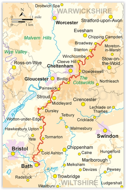
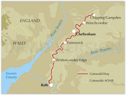
Productomschrijving: Wandelgids over de Cotswold Way Nationale route. Tussen Chipping Campden en Bath verkent de 164 km lange route door de Cotswolds AONB (Area of Outstanding Natural Beauty). Beschreven in beide richtingen over 13 etappes. De Cotswold Way kan het hele jaar door belopen worden, en is geschikt voor beginnende wandelaars. Inclusief apart OS 1:25.000 kaartboekje van de route.
Engelse omschrijving: Guidebook to walking the Cotswold Way National Trail. Between Chipping Campden and Bath, the 102 mile route explores the Cotswolds AONB. Described in both directions over 13 stages, the Cotswold Way can be walked year round and is suitable for beginner trekkers. Includes separate OS 1:25,000 map booklet of the route.
Seasons:
Can be walked all year round: accommodation is scarce during Cheltenham Festival (March) and Badminton Horse Trials (late April/May).
Centres:
Chipping Campden, Cheltenham, Gloucester, Stroud, Bath.
Difficulty:
The Cotswold Way is a waymarked lowland walk suitable for all abilities: suggested day sections are in the region of 6-10 miles (10-16km).
Must See:
Hailes Abbey, Belas Knap, Crickley Hill, Haresfield Beacon, Sudley Castle, Broadway, views of Kelston Round Hill, roman baths (Bath).
Artikelen uit dezelfde regio

Reisgids Cotswolds England - Rough Guides • 9780241308752
Reisgids Cotswolds England - Rough Guides Productomschrijving: The Rough Guide to the Cotswolds AONB is your definitive handbook to one of the most beautiful and diverse holiday destinations in the UK. From stately homes and wildlife parks to modern art galleries, country walks and adventure sports, there is a section that introduces all of the regions’ highlights. For every town and v…

Wandelgids Cotswold classic walks guidebook - Goldeneye • 9781859652602
Wandelgids Cotswold classic walks guidebook Productomschrijving: In eerste instantie is dit wat de engelsen noemen een AONB, een "Area of Outstanding Natural Beauty" die in deze versie verspreidt word over verschillende regio's aangezien zijn grote. Deze plaats van subliem natuurschoon, ligt deel is, Somerset, deels in wawickshire, deels in Wiltshire, deels in Oxfordshire en is de meest be…

Wandelkaart 179 Gloucester Cheltenham & Stroud - OSI • 9780319243725
Wandelkaart Gloucester- Cheltenham & Stroud - Gloucestershire Productbeschrijving: Gloucester & Cheltenham 179 / Gloucester, Cheltenham & Stroud, Gloucestershire, England - Kaart nummer 179 in de OS Explorer reeks heeft betrekking op de omgeving van Gloucester, Cheltenham, Stroud. Hoogtepunten van het gebied zijn onder meer: The Cotswolds AONB gebied van uitzonderlijke natuurlijke scho…

Wandelkaart 163 Cheltenham & Cirencester- England - OSI • 9780319262610
Wandelkaart Cheltenham & Cirencester - England Productbeschrijving: De Cotswold way, de Thames path, en de Europese lange afstand pad, snijden hier beiden doorheen, de OS Landranger kaart 163, bied hier een fantastische locatie om te wandelen en het landschap op te nemen. Cheltenham, het Cultuurcentrum vernoemd naar de Cotswolds, is een historische stad, met winkels en evenementen. In de b…

Wandelgids Walking the Thames Path National Trail - Cicerone • 9781786311481
Thames Path National Trail - Cicerone Productomschrijving: Een gloednieuwe wandelgids vover het Theemspad, een National Trail van 180 mijl tussen de Thames Barrier in Londen en de bron van de rivier in Gloucestershire, door Windsor, Oxford en het platteland. Biedt volledige informatie over deze gemakkelijke route langs de rivier die ongeveer twee weken in beslag neemt. Inclusief een 1:25K …