
Wandelgids The Cleveland Way & Yorkshire Wolds Way - CIcerone
Cleveland Way - Yorkshire Wolds Way - Tabular Hills Walk
Korte omschrijving
Wandelgids The Cleveland Way & Yorkshire Wolds Way - CIcerone Productomschrijving: De vernieuwede wandelgids over de Cleveland Way en Yorkshire Wolds Way National Trails, plus de Tabular Hil...

Specificaties
- Uitgever: CICERONE Press
- ISBN-13: 9781786312211
- HOOFDCATEGORIEËN: Wandelgids
- Activiteiten: Wandelen, Hiking & Trekking
- Auteur: Paddy Dylan
- Regio: Yorkshire, England
- Land: England
- Nationale parken: North York Moors NP, England
- Blz.: 192
- Afmeting: 12x17
- Editie: 3
- Taal: Engels
- Reeks: National Trails, UK
Volledige omschrijving
Wandelgids The Cleveland Way & Yorkshire Wolds Way - CIcerone
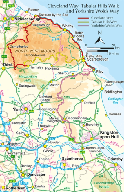
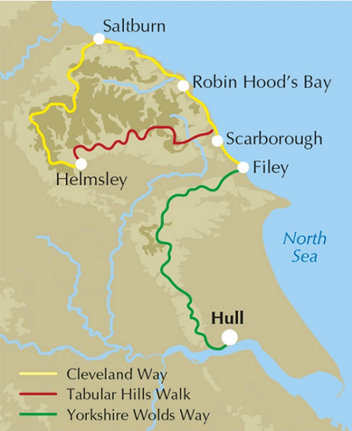
Productomschrijving: De vernieuwede wandelgids over de Cleveland Way en Yorkshire Wolds Way National Trails, plus de Tabular Hills Walk. De drie routes lopen door het North York Moors National Park, langs de kust en op het rustige platteland en kunnen worden samengevoegd tot een gemakkelijke rondwandeling van meer dan 400 km. Inclusief een 1:25.000 schaal OS kaartboekje van de Cleveland Way.
Aparte Map booklet beschikbaar hieronder!
Engelse omschrijving: A walking guidebook to the Cleveland Way and Yorkshire Wolds Way National Trails, plus the Tabular Hills Walk. Crossing the North York Moors National Park, coastal scenery and quiet countryside, the three routes can be joined to create an easy circular route of over 250 miles (400km). Includes a 1:25,000 scale OS map booklet of the Cleveland Way.
Seasons:
All year round, though winter can be bleak and wet on the moors.
Centres:
Scarborough, Whitby, Filey, Helmsley, Osmotherley.
Difficulty:
Suitable for all: the trails are divided into sections ranging from 2½-12 miles. There are some isolated stretches.
Must See:
Yorkshire's Heritage Coast; Ryedale Folk Museum; Rievaulx Abbey; Whitby; historic villages; moorland scenery.
Dorpen & Steden:
Scarborough, Whitby, Filey, Helmsley, Osmotherley
Inhoudsopgave:
The Yorkshire Wolds Way National Trail
Stage 1 Hessle to South Cave
Stage 2 South Cave to Goodmanham or Market Weighton
Stage 3 Goodmanham or Market Weighton to Millington
Stage 4 Millington to Thixendale
Stage 5 Thixendale to Sherburn
Stage 6 Sherburn to Filey
Stage 7 Filey to Scalby Mills (via the Cleveland Way)
The Tabular Hills Walk:
Stage 1 Scalby Mills to Levisham
Stage 2 Levisham to Hutton-le-Hole
Stage 3 Hutton-le-Hole to Helmsley
The Cleveland Way National Trail:
Stage 1 Helmsley to Sutton Bank
Stage 2 Sutton Bank to Osmotherley
Stage 3 Osmotherley to Clay Bank
Stage 4 Clay Bank to Kildale
Stage 5 Kildale to Saltburn-by-the-Sea
Stage 6 Saltburn-by-the-Sea to Sandsend
Stage 7 Sandsend to Robin Hood’s Bay
Stage 8 Robin Hood’s Bay to Scarborough
Stage 9 Scarborough to Filey
Gekoppelde artikelen
Wandelgids The Cleveland Way Map Booklet - Cicerone • 9781786312228
standaard versieThe Cleveland Way Map Booklet - Cicerone Productomschrijving: Kaartboekje van de Cleveland Way National Trail, een 177 km lange wandeling rond het North York Moors National Park. Dit boekje is inbegrepen bij de Cicerone gids voor de Cleveland Way en de Yorkshire Wolds Way en toont de volledige route van de Cleveland Way op OS 1:25.000 kaarten. Dit kaart Boekje zit reeds gratis bijgevoe…
Artikelen uit dezelfde regio

Wandelgids Lake District - Yorkshire Dales - Rother • 9783763344482
Wandelgids Lake District - Yorkshire Dales - Rother Productomschrijving: Het "Lake District" is een nationaal park in het graafschap Cumbria in het noordwesten van Engeland. Het is een van de dertien nationale parken in het Verenigd Koninkrijk. Het is een bergachtige streek. Alle toppen in Engeland hoger dan 900 meter boven zeeniveau liggen in dit gebied. Het hoogste punt in Engeland is de…

Wandelgids Northern England Coast to Coast walk - Cicerone • 9781852847593
Wandelgids - Northern England Coast to Coast walk - Cicerone Productomschrijving: Een wandelgids, uitgebreid in zijn genre, die u van kust naar kust brengt in de noordelijke regio's van Engeland. Deze streek is gekenmerkt door zijn geschiedenis met resten van zelf nog de Romeinse tijd. De regio is ook bekend om zijn Hadrian's Wall path. Product description: First devised by Alfred Wain…

Wandelgids The Cleveland Way - Rucksack Readers • 9781898481973
Wandelgids Cleveland Way - Rucksack Readers Productomschrijving: De Cleveland Way is één van de oudste en meest geliefde National Trails van Engeland. De route loopt over een afstand van 174 km rond het North York Moors National Park en begint in het binnenland bij Helmsley, met een panoramisch uitzicht over de valleien van York en Mowbray en vanaf de Cleveland Hills. Na de kust bij Saltb…

Reisgids Walking the Wharfe - Bradt travel Guides • 9781804691106
Walking the Wharfe - Bradt travel Guides Productomschrijving: In een wereld van globetrottende ontdekkingsreizigers en recordbrekende reizen - waar hij zelf ook deel van uitmaakte - besloot Johno Ellison terug te keren naar zijn roots en de hele lengte van de rivier Wharfe te lopen, de waterweg in Yorkshire waar hij opgroeide. In zijn nieuwe boek voor Bradt, Walking the Wharfe, volgt Ellis…
Wandelgids The Dales Way - Rucksack Readers • 9781898481423
Wandelgids - The Dales Way te Noord Engeland Productomschrijving: Deze charmante wandeling loopt voor 79 mijl van Ilkley in de Yorkshire Dales naar Bowness in het Lake District. De LDWA heeft gedocumenteerde routes voor wandelaars beginnend in Leeds, Harrogate en Bradford. Langs de weg ziet u de indrukwekkende spoorwegviaducten en fijne stenen bruggen, de Bolton Priorij en vele kleine kerk…