
Wandelgids Short Treks in Corsica - Cicerone
5 van de populairste kortere tochten van het eiland
Korte omschrijving
Short Treks in Corsica - Cicerone Press Productomschrijving: Met spectaculaire berglandschappen, prachtige ruige kusten, bossen, en opvallende rivierkloven, is Corsica een paradijs voor wand...

Specificaties
- Uitgever: CICERONE Press
- ISBN-13: 9781786310590
- HOOFDCATEGORIEËN: Wandelgids
- Activiteiten: Wandelen, Hiking & Trekking
- Auteur: Gillian Price
- Regio: Corsica, Frankrijk
- Land: Frankrijk
- Blz.: 176
- Afmeting: 12x17
- Editie: 1
- Taal: Engels
Volledige omschrijving
Short Treks in Corsica - Cicerone Press
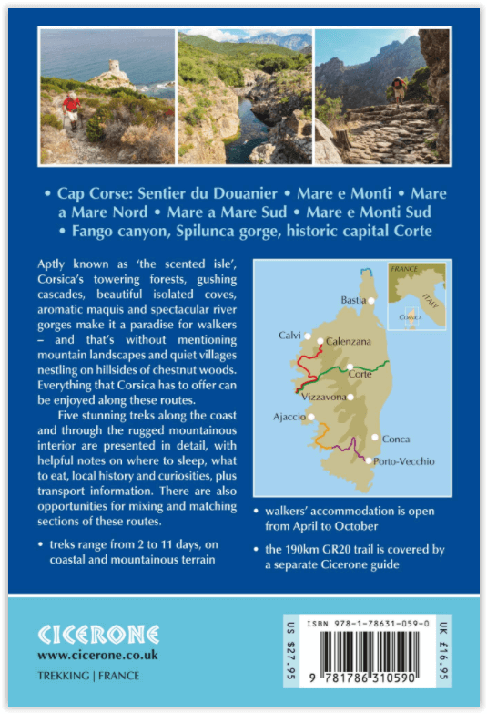
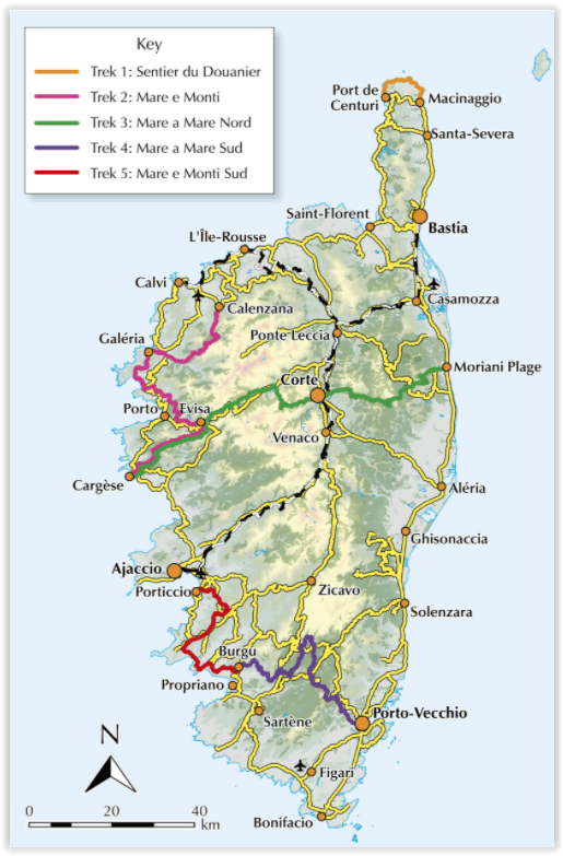
Productomschrijving: Met spectaculaire berglandschappen, prachtige ruige kusten, bossen, en opvallende rivierkloven, is Corsica een paradijs voor wandelaars. Deze gids beschrijft 5 van de populairste kortere tochten van het eiland: de 2-daagse Sentier du Douanier langs de kust (Customs Officer's Path) rond Cap Corse, 2 routes van kust tot kust door de centrale bergen, de 11-daagse Mare a Mare Nord en de 5-daagse Mare a Mare Sud en twee 'kust en bergen'-routes, de 10-daagse Mare e Monti en de 5-daagse Mare e Monti Sud.
(Corsica's beroemde 190 km lange GR20-route wordt beschreven in een aparte Cicerone-gids.) De routes kunnen worden gekoppeld om langere excursies te creëren en accommodatie wordt geboden door een mix van herbergen, B & B's en hotels voor wandelaars; kamperen is ook een optie.
Engelse omschrijving: With spectacular mountain landscapes, beautiful rugged coast, forests, maquis and striking river gorges, Corsica is a walker's paradise. This guidebook details five of the islands's most popular shorter treks: the 2-day coastal Sentier du Douanier (Customs Officer's Path) around Cap Corse; two coast-to-coast routes through the central mountains, the 11-day Mare a Mare Nord and the 5-day Mare a Mare Sud; and two 'coast and mountains' routes, the 10-day Mare e Monti and the 5-day Mare e Monti Sud.
(Corsica's famous 190km GR20 trail is described in a separate Cicerone guide.) The routes can be linked to create longer excursions and accommodation is provided by a mixture of walkers' hostels, B&Bs and hotels; camping is also an option.
The guide presents each of the waymarked trails in daily stages averaging around 12-13km per day, with route description, mapping and notes on accommodation options. There is advice on how to get to Corsica, when to go and what to take, plus accommodation listings, useful contacts and a French/Corsican-English glossary. The guide also offers a wealth of information about the island's rich plant and wildlife.
Considerably easier than the challenging GR20, these trails offer a more accessible option for trekkers wishing to experience the 'real' Corsica, away from the bustling coastal resorts. You'll find enchanting scenery - towering forests, gushing cascades, turquoise coves, aromatic maquis, rugged mountains and quiet villages nestling on hillsides of chestnut woods - not to mention a favourable climate and delicious local cuisine. Don't be surprised if you fall under the island's spell!
Locatie op kaart
Overzichtskaarten

GR20 Wandelroutes Corsica - Tour du solitude
GR20 Wandelroutes Corsica - Tour du solitude

Producten op de overzichtskaart
Klik op een product om naar de detailpagina te gaan.
- Wandelkaart 2251 - Corsica Zuid - Kompass
- Wandelkaart - Le GR20 Corse - Didier Richard
- Wandelgids Corsica - 70 wandelingen - ELMAR
- Wandelgids - Corsica GR20 - The high level route - Cicerone
- Wandelgids - Corsica GR20 - Knife Edge
- Wandelgids - GR 20 Corse - 16 jours de marche - Belle Balades
- Wandelkaart 09 Corsica zuid - Corse du Sud - Didier Richard
- Wandelgids - Corsica GR20 - The high level route - Cicerone
- Wandelgids - GR20 - A travers la montagne Corse - FFR
- Wandelgids - GR20 - Fra li monti - la légende corse - Ed.Glénat
- Wandelgids 067 - A travers la montagne Corse - GR20 - FFR
- Wandelgids - Short Treks in Corsica - Cicerone
- Wandelkaart - GR 20 Traversee de la Corse - IGN
Artikelen uit dezelfde regio


Wandelkaart 2251 - Corsica Zuid - Kompass • 9783990444016
Wandelkaart Corsica Zuid - Kompass Productomschrijving: Een 3 delige wandelkaart van de mooie ruige eilandformaten van Zuid-Corsica. Een Frans eiland dat niet weerlaat om de mooie natuur aan u te tonen. Ook niet de wereldbefaamde GR20 wandelroute die er deels doorloopt. Om de volledige GR20 te zien, moeten u de kaarten 2050 & 2251 (deze) hebben. Corsica is het Franse eiland in de Middellan…

Wandelkaart Fietskaart D2B Haute-Corse - IGN • 9782758553298
Wandelkaart Fietskaart D2B Haute-Corse - IGN Productomschrijving: Een nieuwe reeks met een nieuwe departementale indeling. De reeks bevat fietsroutes in samenwerking met de vereniging AF3V - VéloRoutes et Voies Vertes. Dankzij de schaal van 1:100.000 (1 cm = 1 km) is de nieuwe TOP 100 de ideale kaart om een regio te voet, op de fiets of met de auto te ontdekken. De kaart bevat een breed sc…

Wandelkaart 09 Corsica zuid - Corse du Sud - Didier Richard • 9782723476720
Wandelkaart Corsica zuid - Corse du Sud - Didier Richard Productomschrijving: Corsica is de thuis van de GR20, de befaamde route du solitude over de centrale dicht beboste wandelroutes van PNR du Corse. Deze routes is op deze kaart tevens ook ingetekend. Met de topografische data van IGN, de Franse topo dienst. Deze kaartenreeks biedt een uitstekend overzicht van delen van de bekende w…

Wandelgids Corse - Vacances actives en famille - Rother • 9783763349432
Wandelgids Corsica - Corse - Vacances actives en famille - Rother Corsica - actieve gezinsvakantie wandelingen enz... Productomschrijving: Een paar toeristische bestemmingen die zo divers zijn, vol voorzieningen, evenals de passie-Nantes, dat het eiland Corsica over beschikt. De wandelingen voor jong en oud zijn prachtig, de droom stranden en de onvergelijkbare kristalheldere zee. De s…

Wandelgids Haute-Corse - 28 balades en famille - Ed. Glénat • 9782344055014
Wandelgids Haute-Corse - 28 balades en famille - Glénat Productomschrijving: 28 wandelingen om alle pracht en praal van de Haute-Corse te ontdekken. Aangeboden vanuit de belangrijkste kustplaatsen Bastia, Calvi, Île-Rousse en Saint-Florent, maar ook vanuit Corte, de citadel van het binnenland, kunnen deze 28 wandelingen het hele jaar door worden overwogen, met het hele gezin! Omvat: Ca…