Wandelgids Isle of Arran walking guide - Cicerone
45 walking routes in this Isle of Arran
Korte omschrijving
Isle of Arran walking guide - Cicerone Productomschrijving: De 45 wandelroutes in deze Isle of Arran gids variëren van gemakkelijke 3 km (2 mijl) natuurpaden tot lange zware bergroutes met s...

Specificaties
- Uitgever: CICERONE Press
- ISBN-13: 9781786311351
- HOOFDCATEGORIEËN: Wandelgids
- Activiteiten: Wandelen, Hiking & Trekking
- Auteur: Paddy Dylan
- Regio: Isle of Arran, Schotland, North Ayrshire, Schotland
- Land: Schotland
- Blz.: 272
- Afmeting: 12x17
- Editie: 4
- Taal: Engels
Volledige omschrijving
Isle of Arran walking guide - Cicerone
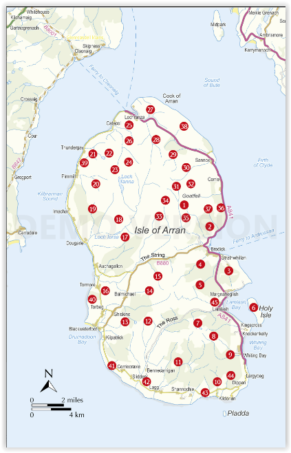
Productomschrijving: De 45 wandelroutes in deze Isle of Arran gids variëren van gemakkelijke 3 km (2 mijl) natuurpaden tot lange zware bergroutes met scrambles (tot 32 km) en bieden een grondige dekking van Arran, inclusief de beklimming van Goatfell en het nabijgelegen Holy Isle. De meeste routes zijn 10 tot 15 km lang, maar veel routes bieden de mogelijkheid om langere wandelingen over het eiland te maken.
Engelse omschrijving: The 45 walking routes in this Isle of Arran guidebook range from easy 3km (2 miles) nature trails to long arduous mountain routes with scrambles (up to 32km) providing thorough coverage of Arran, including the ascent of Goatfell and nearby Holy Isle. Most routes are 10 to 15km long but many give opportunities to create longer cross-island walks.
Seasons:
Arran is good for walking year-round: be aware that the island's population triples in the peak summer period, and deer stalking occurs mid-August to mid-October.
Centres:
Brodick; Lamlash; Lochranza.
Difficulty:
This guidebook include a few easy, waymarked forest trails or low-level walks and a dozen or so moderate glen or hill walks. The rest require more effort, involving higher mountains, sometimes with hands-on scrambling. There are roads and forest tracks, hill tracks or paths, but many routes also cross pathless slopes and traverse rocky mountain ridges.
Must See:
Walk Goatfell, Holy Isle, Beinn Nuis, Beinn Tarsuinn, the Sannox Horseshoe, Glen Rosa and the Cock of Arran Over 40 routes giving thorough coverage of this wild but accessible Scottish island Varied walking includes all the island's best and classic routes.

Artikelen uit dezelfde regio

Wandelkaart XT25 Arran & Arran Coastal Way - Harvey maps • 9781851375264
Wandelkaart Arran & Arran Coastal Way - Schotland - Harvey maps Productomschrijving: De Arran Coastal Way is een 100 kilometer lange afstand die rond de kust van Arran in Schotland loopt Nieuwe generatie HARVEY Superwalker, XT25 waterproof, werden ontworpen om de meest praktische tools te zijn voor GPS-navigatie. Het formaat geeft meer toewijzingen op het blad zonder de kaart zwaarder …


