
Wandelgids - GR10 Trail through the French Pyrenees - Cicerone
Le Sentier des Pyrénées- 955km lange tocht door de Pyreneeën
Korte omschrijving
Wandelgids - GR10 Trail through the French Pyrenees - Cicerone Productomschrijving: Wandelgids over de GR10, "Le Sentier des Pyrénées", een 955km lange tocht door de Franse Pyreneeën van He...

Stockactie
Specificaties
- Uitgever: CICERONE Press
- ISBN-13: 9781852847739
- HOOFDCATEGORIEËN: Wandelgids
- Activiteiten: Wandelen, Hiking & Trekking
- Regio: Occitanië, Frankrijk
- Land: Frankrijk
- Departement: Pyrénées-Orientales (66)
- Blz.: 320
- Afmeting: 12x17
- Editie: 1
- Taal: Engels
Volledige omschrijving
Wandelgids - GR10 Trail through the French Pyrenees - Cicerone
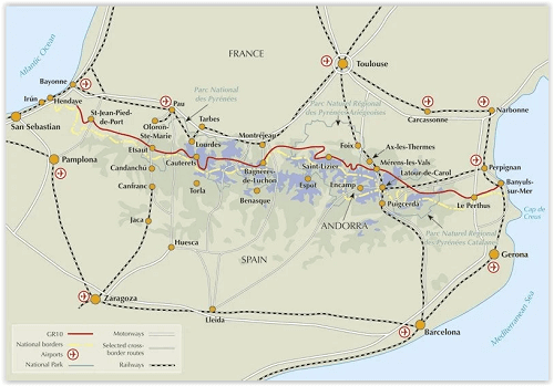
Productomschrijving: Wandelgids over de GR10, "Le Sentier des Pyrénées", een 955km lange tocht door de Franse Pyreneeën van Hendaye aan de Atlantische kust tot de Middellandse Zeekust in Banyuls-sur-Mer. Het boek beschrijft 55 etappes, met informatie over planning, vervoer, accommodatie en faciliteiten. U kunt de hele GR10 in ongeveer 45 dagen of in korter afleggen.
Productdescription: Guidebook to walking the GR10, the Sentier des Pyrénées, a 955km trek across the French Pyrenees from Hendaye on the Atlantic Coast to the Mediterranean coast at Banyuls-sur-Mer. The book describes 55 stages, with information on planning, transport, accommodation and facilities. Walk the entire GR10 in around 45 days or in shorter trips.
Product description: Guidebook to walking the GR10, the Sentier des Pyrénées, a 955km trek across the French Pyrenees from Hendaye on the Atlantic Coast to the Mediterranean coast at Banyuls-sur-Mer. The book describes 55 stages, with information on planning, transport, accommodation and facilities. Walk the entire GR10 in around 45 days or in shorter trips.
Seasons:
Best July to October (June in a low snow year).
Centres:
Hendaye-Plage on the Atlantic coast to Banyuls-sur-Mer on the Mediterranean through the French Pyrenees.
Difficulty:
The GR10 is extremely well waymarked following good mountain paths with short sections of boulderfield and occasional very easy scrambling. It is tough because there is more steep climb and descent than on many long-distance paths. Good network of inexpensive accommodation for those who prefer not to camp. Frequent resupply possible. In early season (May/June) ice-axe and crampons may be required.
Must See:
The GR10 starts with the rolling hills of the Basque country leading to the High Pyrenees including Pic du Midi d'Ossau, Vignemale and Gavarnie. The remote Ariège with Mont Vallier follows and Canigou dominates the approach to the Mediterranean. Wildflower meadows are magnificent throughout.
Locatie op kaart
Artikelen uit dezelfde regio

Wandelgids Aude Frankrijk - 30 balades à pied - Ed. Chamina • 9782844662453
Wandelgids - Aude Frankrijk - 30 balades à pied - Ed. Chamina Productomschrijving: De mooiste wandeltochten, gecombineerd in één boek met praktische tips & pagina's gewijd aan de ontdekking van het erfgoed, gedetailleerde beschrijvingen en gemakkelijk leesbare kaarten. Franse omschrijving: Les plus belles randonnées, issues d'une sélection rigoureuse, réunies en un seul ouvrage avec c…

Wandelgids- Hautes-Pyrénées- Vallées des Gaves à pied - Chamina • 9782844662675
Wandelgids- Hautes-Pyrénées- Vallées des Gaves à pied - Chamina Productomschrijving: Het land van "le Parc national des Pyrénées" zorgt voor de bescherming van het milieu van dit centrale deel van de keten. Hier worden de opmerkelijke plaatsen met de tientallen geteld: Lourdes, Cauterets, Luz-Saint-Sauveur, Argeles-Gazost, Val d'Azun. De toppen zijn prestigieuze toppen als: (Vignemale hoo…

Wandelkaart 12 Gavarnie en Ordesa PN - Rando • 9782344026663
Wandelkaart 12 - Gavarnie en Ordesa - Rando Productomschrijving: De locaties liggen langs beide zijden van de taalgrens, deels in Frankrijk namelijk, Gavarnie-Gédre en dan het Ordesa deel over de Spaanse grens. Het Spaanse del omvat het Nationaal Park Ordesa y Monte Perdido Omvat: Balaïtous / VIgnemale / Mont Perdu / Het Nationaal Park Ordesa y Monte Perdido

Wandelkaart Midi d'Ossau - Balaitus - PN Pyrénées Ouest - Alpina • 9788470110948
Wandelkaart Midi d'Ossau & Balaitus - IGN Productomschrijving: Het Nationaal park van de Pyreneeën strekt zich uit voor 100 km, 6 valleien, 2 departementen & 2 regio's. Deze kaart bestaat uit 2 kaarten, en omvatten de westelijke zijde van het nationaal park. Omvat de massieven van de Vignemale, Balaitus en de piek van de Midi d'Ossau. Omvat: Het Nationaal Park Pyreneeën. Pyrénées-Atlan…

Wandelgids Loudenvielle et la vallée du Louron à pied - FFR • 9782751412196
Loudenvielle et la vallée du Louron à pied - FFR Productomschrijving: In het hart van de Pyreneeën, na Tarbes en Lannemazan, verlaat u bij Arreau, de weg naar Spanje om de vallei van Louron te ontdekken met zijn ongerepte landschappen en dorpen met een rijk seculier erfgoed. Welkom in de Louron Vallei! In een gebied dat het label "Pays d'art et d'histoire" draagt, zult u versteld staan…