Wandelgids Fife Pilgrim Way - Rucksack Readers
Culross - North Queensferry -
Korte omschrijving
Wandelgids Fife Pilgrim Way - Rucksack Readers Productomschrijving: Deze route loopt van de Firth of Forth bij Edinburgh naar de beroemde pelgrimsbestemming St Andrews. Andrews. De route is ...

Specificaties
- Uitgever: RUCKSACK READERS
- ISBN-13: 9781913817183
- HOOFDCATEGORIEËN: Wandelgids
- Activiteiten: Wandelen, Hiking & Trekking
- Auteur: Duncan Weaver, Jacquetta Megarry
- Regio: Fife, Schotland
- Land: Schotland
- Lange afstand wandelroutes: Fife Pilgrim Way, Fife Schotland
- Blz.: 72
- Schaal: 1:40000
- Afmeting: 13x22
- Editie: 1
- Taal: Engels
Volledige omschrijving
Wandelgids Fife Pilgrim Way - Rucksack Readers
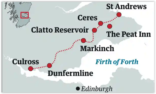
Productomschrijving: Deze route loopt van de Firth of Forth bij Edinburgh naar de beroemde pelgrimsbestemming St Andrews. Andrews. De route is rijk aan industrieel erfgoed en voert langs voormalige mijnbouwgemeenschappen, spoorwegen, textielcentra en kastelen, maar bovenal viert de route het pelgrimskoninkrijk en de geschiedenis van Fife via de vele kerken en andere religieuze plaatsen.
De route begint ofwel in het historische dorp Culross, of bij de pelgrimssteiger in North Queensferry en loopt over een afstand van 89 km van west naar oost door Fife. De meeste wandelaars hebben 5-6 dagen nodig om de tocht te voet af te leggen. Fietsers met mountainbikes of gravelfietsen kunnen het grootste deel van de route onder de meeste omstandigheden in 2-3 dagen afleggen, maar zullen soms - als de grond erg nat is of het pad te smal - moeten afstappen.
Engelse omschrijving: This route runs from the Firth of Forth near Edinburghto the famous pilgrim destination, St Andrews. It is rich in industrial heritage, passing through former mining communities, railways, textile centres and castles.Above all, it celebrates Fife’s pilgrim kingdom and history through its many churches and other religious sites.
Starting either from the historic village of Culross, or the pilgrim landing at North Queensferry, it runs for 55 miles (89 km) from west to east across Fife. Most walkers will take 5-6 days to complete the journey on foot. Cyclists with mountain or gravel bikes can ride most of the route in most conditions over 2-3 days, but may sometimes – where the ground is very wet or the path too narrow – need to dismount.
Features:
This guidebook contains all you need to plan and enjoy the Fife Pilgrim Way on foot or bike:
- detailed route description divided into manageable sections
- summaries showing distance, terrain and refreshment stops
- 12 pages of detailed mapping with the route highlighted (1:40,000)
- background on Fife’s pilgrim history, heritage and wildlife
- planning information for travel by car, bus and plane
- lavishly illustrated, with nearly 100 colour photographs
- rainproof paper throughout.

Locatie op kaart
Artikelen uit dezelfde regio

Wandelgids Mary Queen of Scots Way - Rucksack readers • 9781898481485
Wandelgids Mary Queen of Scots Way - Schotland Productomschrijving: Deze nieuwe route doorkruist Centraal Schotland van kust tot kust, en is verbonden met vele plaatsen die geassocieerd zijn met Mary Queen of Scots. Het loopt voor 107 mijl (172 km) van Arrochar op Loch Long naar St Andrews op de kust van Fife, Loch Lomond kruist met de veerboot naar Inversnaid en gaat dan via Aberfoyle, Ca…

Wandelkaart 59 St-Andrews- Fife- Schotland - OSI • 9780319473825
Wandelkaart St-Andrews - Fife Schotland Productbeschrijving: OS Landranger kaart 59 toont St-Andrews, Kirkcaldy en Glenrothes tussen de Firth of Forth en de Firth of Tay. St Andrews is het best bekend als de geboorteplaats van het golfen, en nog steeds duizenden bezoekers trekt naar de Links-corse. Het heeft ook een van de oudste universiteiten in de wereld. De OS Landranger kaarten reeks …

Wandelkaart 59 St-Andrews Fife Schotland - OSI • 9780319261576
Wandelkaart 59 - St-Andrews - Fife Schotland Productbeschrijving: OS Landranger kaart 59 toont St-Andrews, Kirkcaldy en Glenrothes tussen de Firth of Forth en de Firth of Tay. St Andrews is het best bekend als de geboorteplaats van golf, en nog steeds trekt de plaats duizenden bezoekers naar de Links-cors. Het heeft ook één van de oudste universiteiten in de wereld. De OS Landranger ka…

Wandelkaart 367 Dunfermline- Kirkcaldy & Glenrothes - OSI • 9780319246153
Wandelkaart Dunfermline- Kirkcaldy & Glenrothes South - Schotland Productbeschrijving: Methil & Culross. 367 / Dunfermline, Kirkcaldy & Glenrothes South, Fife, Schotland - OS Explorer kaart 367 toont Dunfermline, Kirkcaldy en te Firth of Forth. Het Fife kustpad (deel van de North Sea Trail) is inbegrepen, alsook de Lomond Hills Regionaal Park en Loch erts. De OS Explorer kaart voor Dun…

Wandelkaart 370 Glenrothes North & Falkland- Schotland OSI • 9780319472378
Wandelkaart Glenrothes North- Falkland & Lomond Hills - Schotland Omvat ook: Auchtermuchty & Cupar. Productbeschrijving: Kaart nummer 370 omvat Glenrothes North, Falkland en Lomond hills. Hoogtepunten zijn West Lomond river Eden, Largo Bay en Fife kustpad. Omvat ook Auchtermuchty en Cupar. De OS Explorer kaart voor Glenrothes North, Falkland & Lomond Hills is beschikbaar in zowel de st…


