
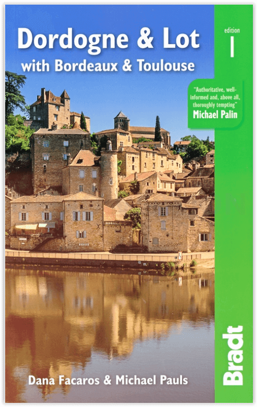
Reisgids Dordogne & Lot with Bordeaux & Toulouse - Bradt guides
Inclusief Bordeaux & Toulouse
Korte omschrijving
Reisgids Dordogne & Lot with Bordeaux & Toulouse - Bradt Productomschrijving: Bradt's Dordogne & Lot, met Bordeaux & Toulouse is de meest gedetailleerde gids voor de hele regio, met een dekk...

Specificaties
- Uitgever: Bradt guides
- ISBN-13: 9781784779009
- HOOFDCATEGORIEËN: Reisgids
- Activiteiten: Toerisme
- Regio: Occitanië, Frankrijk
- Land: Frankrijk
- Departement: Dordogne (24), Lot (46)
- Blz.: 408, 416
- Afmeting: 14x22
- Editie: 1
- Taal: Engels
Volledige omschrijving
Reisgids Dordogne & Lot with Bordeaux & Toulouse - Bradt
Productomschrijving: Bradt's Dordogne & Lot, met Bordeaux & Toulouse is de meest gedetailleerde gids voor de hele regio, met een dekking die de Lot-et-Garonne en Tarn-et-Garonne omvat, naast Dordogne, Lot en Bordeaux. Dana Facaros en Michael Pauls (auteurs van de oorspronkelijke Cadogan gids voor het gebied) hebben meer dan dertig jaar in de Lot-vallei gewoond en zijn de perfecte gidsen voor de landschappen, steden, eten, kunst, architectuur en, natuurlijk, de wijn van de regio: De 8.800 wijnchâteaux van Bordeaux produceren gemiddeld 650 miljoen flessen per jaar!
Engelse omschrijving: Bradt’s Dordogne & Lot, with Bordeaux & Toulouse is the most detailed guide to the entire region, with coverage that includes the Lot-et-Garonne and Tarn-et-Garonne in addition to Dordogne, Lot and Bordeaux. Dana Facaros and Michael Pauls (authors of the original Cadogan guide to the area) have lived in the Lot valley for over thirty years and are the perfect guides to the region’s landscapes, towns, food, art, architecture and, of course, wine: Bordeaux’s 8,800 wine châteaux produce on average 650 million bottles a year!
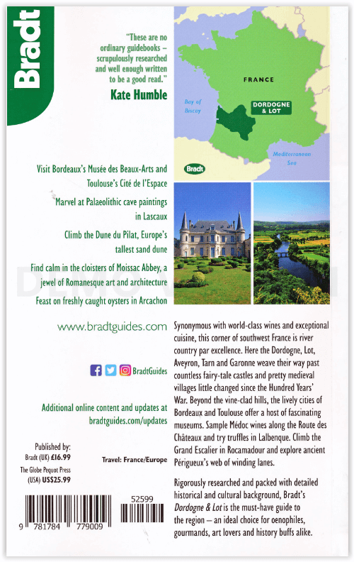
Their guide starts with Bordeaux, the capital of the Nouvelle-Aquitaine region as well as the world capital of wine, along with the départements of the Gironde, Dordogne, Lot, Lot-et-Garonne, and Tarn-et-Garonne in between. This is a land of great wines and stunning rivers, encompassing long sandy beaches along the Côte d’Argent (with Europe’s biggest sand dune on the south end), forests and rolling hills. Here, too, are the UNESCO-listed Prehistoric Sites and Decorated Caves of the Vézère Valley, and extraordinary Palaeolithic masterpieces (Lascaux, Font de Gaume and Pech Merche). History has been made here, evidenced in medieval castles and bastides, and beautiful old cities such as Sarlat, Périgueux, St-Emilion, Cahors and Figeac. Hundreds of unspoiled villages dot landscapes that are among the most idyllic in France, while Romanesque churches, including the great abbey at Moissac, are a feast for art lovers.
Outdoor activities are well covered, too, including cycling, sailing, surfing, canoeing, kayaking and walking the numerous Grand Randonnées (including three main routes of the Camino de Santiago) that pass through here, along with scores of other paths. And last but not least, the food is good: think truffles, oysters, duck, saffron, strawberries and melons, walnut groves and orchards. The weekly markets are gorgeous, and the summers are filled with wine, music and theatre festivals. All of this and more is covered by expert authors Dana Facaros and Michael Pauls in this new title from Bradt, offering all the information you need both prior to departure and while on the road.
Locatie op kaart
Artikelen uit dezelfde regio

Wandelkaart 2047 OT St-Girons & Couserans - IGN • 9782758545262
TOPO Wandelkaart St-Girons & Couserans - IGN Productomschrijving: St-Girons & Couserans zijn beiden gemeentes in het Franse departement Ariège in de regio Occitanie. De plaats maakt deel uit van het arrondissement Saint-Girons, en zijn gelegen in het befaamde natuurpark "Parc Naturel Régional des Pyrénées Ariégeoises". Het spreekt voor zich, dan deze plaatsen de perfecte uitvalsbasissen zi…

Wandelkaart 2441 SB Réquista & Villefranche-de-Panat - IGN • 9782758534297
Wandelkaart - Réquista & Villefranche-de-Panat Productomschrijving: Deze topografische kaarten hebben een zeer nauwkeurige gronddetail, niet te vergeten de topografische hoogteprofielen, die het wandelen een stuk gemakkelijker maken. Réquista is een gemeente in het Franse departement Aveyron (regio Midi-Pyrénées) en telt 2099 inwoners (2004). De plaats maakt deel uit van het arrondissemen…

Wandelgids Ariège- 30 balades à pied - Ed. Chamina • 9782844663511
Wandelgids - Ariège- 30 balades à pied - Ed. Chamina Productomschrijving: 30 van de mooiste wandeltochten, een strenge selectie, gecombineerd in één boek met praktische tips, pagina's gewijd aan de ontdekking van het erfgoed, gedetailleerde beschrijvingen en gemakkelijk leesbare kaarten. Franse omschrijving: Les plus belles randonnées, issues d'une sélection rigoureuse, réunies en un s…

Wandelkaart 1743 SB Plaisance & Montesquiou - IGN • 9782758553793
Wandelkaart Plaisance & Montesquiou - IGN Productomschrijving: Plaisance & Montesquiou zijn gemeentes in het Franse departement Gèrs in de regio Occitanie. De plaats maakt deel uit van het arrondissement Mirande. Omvat: Belmont, Aignan, Préchac-sur-Adour, Roquebrune, Tieste-Uragnoux, Saint-Aunix-Lengros, Galiax, Ladevèze-Rivière, Beaumarchés, Hères, Jû-Belloc, Lasserade, Bouzon-Gellena…

Wandelgids Vallées de Gavarnie itin. de 2 à 6 jours - Rando • 9782344057810
Vallées de Gavarnie, itin. de 2 à 6 jours - Rando Productomschrijving: In het hart van de Hautes-Pyrénées, negen routes in etappes, van hut naar hut, om je onder te dompelen in deze streken en nog meer te genieten van de magie van de plek. In het hart van het Nationaal Park van de Pyreneeën, in een omgeving die 100% groen, milieuvriendelijk, verantwoord en vooral duurzaam is, waar de t…