
Fietsgids La Vélobuissonnière - Ed. Chamina
De la Normandie à la Loire - Alençon - Le Mans - Saumur


Korte omschrijving
La Vélobuissonnière - Chamina Productomschrijving: Deze gids neemt je mee op het avontuur van de Vélobuissonnière. De route loopt van Alençon naar Saumur. De route loopt door de departemente...

Specificaties
- Uitgever: Chamina édition
- ISBN-13: 9782844666604
- Activiteiten: Fietsen / VTT / MTB
- Auteur: Paulo Moura
- Regio: Alençon, Le Mans, Loire, Frankrijk, Normandië, Frankrijk
- Departement: Maine-et-Loire (49), Orne (61), Sarthe (72)
- Blz.: 48
- Afmeting: 12x21
- Taal: Frans
Volledige omschrijving
La Vélobuissonnière - Chamina
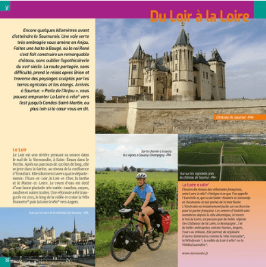
Productomschrijving: Deze gids neemt je mee op het avontuur van de Vélobuissonnière. De route loopt van Alençon naar Saumur. De route loopt door de departementen Orne, Sarthe en Maine-et-Loire. De Vélobuissonnière (ook bekend als de V44) volgt zowel speciale fietsroutes als weinig bereden wegen en de route is volledig bewegwijzerd. Je komt door steden en dorpen die bekend staan om hun rijke geschiedenis en uitzonderlijke erfgoed: Alençon, Le Mans, La Flèche, enz.
Elke etappe gaat vergezeld van thematische teksten over elementen die je onderweg tegenkomt. Tot slot kunt u bij aankomst in Saumur aansluiten op de Loire à Vélo, de ster van de fietsroutes.
Vertaald met DeepL.com (gratis versie)
Franse omschrijving: Ce guide vous emmène tout au long de l’aventure de la Vélobuissonnière. Le tracé va d’Alençon à Saumur. Il traverse ainsi les départements de l’Orne, de la Sarthe, et du Maine-et-Loire. La Vélobuissonnière (aussi dénommée V44), suit soit des véloroutes en site propre, soit des routes très peu fréquentées, et le parcours est entièrement balisé. Vous traverserez des villes et villages connues pour leur riche histoire et leur patrimoine exceptionnel : Alençon, Le Mans, La Flèche, etc.
Chaque étape est associée à des textes thématiques sur des éléments croisés sur le parcours. Enfin, à l’arrivée à Saumur, la jonction peut se faire avec la Loire à Vélo, star des véloroutes.
Caractéristiques:
* Format à spirale pour l'emporter partout
* Une présentation claire et pratique de l’itinéraire
* Des sites touristiques et curiosités à ne pas manquer sur le parcours
* 10 étapes et 3 escapades dans les départements de l’Orne, Maine-et-Loire et la Sarthe.
* Un itinéraire de 231 km et 126 km d’escapades (Sablé-sur-Sarthe, Le Lude et Candes-Saint-Martin)
Artikelen uit dezelfde regio
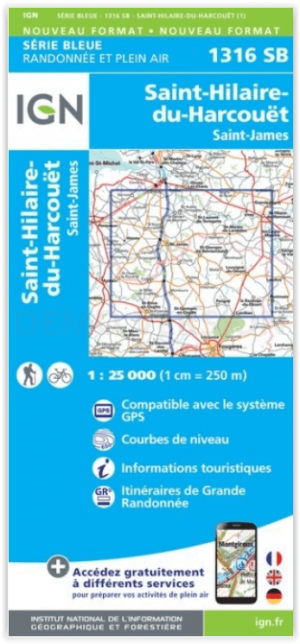
Wandelkaart 1316 SB St-Hilaire-du-Harcouët - St-James - IGN • 9782758545941
Wandelkaart St-Hilaire-du-Harcouët - St-James - IGN Productomschrijving: St-Hilaire-du-Harcouët & St-James zijn gemeentes in het Franse departement Manche in regio Normandië. De plaatsen maken deel uit van het arrondissement Avranches. De TOP 25-serie is de cartografische referentie in Frankrijk: - Een nauwkeurige beschrijving van het grondgebied op een schaal van 1: 25.000 (1 cm = 2…

Wandelkaart 1512 OT Bayeux Normandie - IGN • 9782758540960
TOPO Wandelkaart Bayeux Normandie - IGN Productomschrijving: Bayeux is een Franse stad in het departement Calvados in de regio Normandië. Bayeux ligt ongeveer 270 km van Parijs en 31 km van Caen, niet ver van Het Kanaal vandaan. De stad is bekend om het Tapijt van Bayeux. In de stad staat een beroemde kathedraal. De stad is gesticht in de Keltische tijd. De naam van de stad stamt af van de…

Wandelkaart 1314 SB Villedieu-les-Poëlles & Gavray - IGN • 9782758547037
Wandelkaart 1314 SB - Villedieu-les-Poëlles & Gavray Productomschrijving: Villedieu-les-Poëlles & Gavray zijn gemeentes in het Franse departement Manche in de regio Normandië. De plaats maakt deel uit van het arrondissement Saint-Lô. Een gloed nieuwe reeks IGN kaarten: de oude versies met de Est en Ouest (E en O aanduiding achter het nummer van de kaart) verdwijnen en worden vervangen…

Wandelgids l'Eure à pied- 45 circuits à pied - FFR • 9782751410246
Wandelgids D027 - l'Eure à pied- 45 circuits à pied Productomschrijving: Dit departement bestaan grotendeels uit de prachitge valleien van de l'Eure, de Risle en de l'Iton. Zonder de grandiose perspectieven mee te tellen van de Coteaux crayaux van de Seine gedomineerd door het kasteel Château Gaillard. Het omvat het departement die het meest bebost is van alle andere, en één met een hoog c…

Reisgids GEOguide Normandie - Gallimard • 9782742463107
Reisgids Normandie - Gallimard Productomschrijving: De normandische kust is onder meer wereldwijd gekend voor zijn Mont-St-Michèl, en de D-day stranden, Alencon, Arromanches, Bagnoles-de-l'orne, Bayeux, Cabourg, Caen, Cherbourg-en-Cotentin, Deauville, Etretat, Dieppe, Falise, Fecamp, Giverni, Ggranville-en-chausey, Le Havre, Honfleur, île-Tatihou-en-Saint-Vaast-la-Hougue, Lisieux, Nez-de-J…