
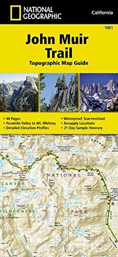
Wandelkaart 1001 - John Muir Trail - Nat Geo
Doorkruist Yosemite- Kings Canyon en Sequoia National Park
Korte omschrijving
TOPO Wandelkaart 1001 - John Muir Trail - National Geographic Productomschrijving: De John Muir Trail - is een langeafstandswandelpad in het Sierra Nevada-gebergte in de Amerikaanse staat Ca...

Specificaties
- Uitgever: National Geographic
- ISBN-13: 9781566956895
- HOOFDCATEGORIEËN: Wandelkaart
- Activiteiten: Wandelen, Hiking & Trekking
- Regio: Californië, USA
- Land: Verenigde Staten van Amerika (USA)
- Lange afstand wandelroutes: John Muir Way (215 km)
- Blz.: 48
- Schaal: 1:63360
- Afmeting: 10x19
- Taal: Engels
Volledige omschrijving
TOPO Wandelkaart 1001 - John Muir Trail - National Geographic
Productomschrijving: De John Muir Trail - is een langeafstandswandelpad in het Sierra Nevada-gebergte in de Amerikaanse staat Californië. Het is vernoemd naar de Schots-Amerikaanse natuurvorser en schrijver John Muir, die een cruciale rol speelde in de bescherming van de nationale parken van Californië. Het 338,6 kilometer lange pad doorkruist Yosemite, Kings Canyon en Sequoia National Park. Het merendeel van het pad (zo'n 260 km) valt samen met de Pacific Crest Trail, dat van de Mexicaanse grens naar de Canadese loopt.
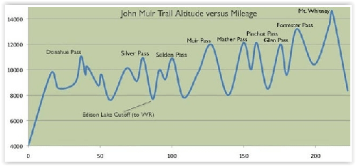
Engelse omschrijving: National Geographic's Map Guide of the John Muir Trail is an indispensable tool for navigating one of the most famous trails in the United States. Expertly researched and created in partnership with local land management agencies, this product provides detailed topographic maps, interesting history, a waypoint table, information about wilderness safety, and key points of interest you will encounter along the trail. A resupply location chart shows shipping address/contact information, distances, and services available at each resupply point. Each map page has a detailed trail profile that shows the elevation changes you will encounter. Also, the John Muir Trail is highlighted and centered on each page so you can easily track your progress.
The maps start at the northern terminus in Yosemite Valley and progress along the ridge of the Sierra Nevada, past Devils Postpile, and end at the highest point in the lower 48 on the top of Mount Whitney. Along the way you will pass through; Yosemite National Park, Ansel Adams Wilderness, Devils Postpile National Monument, John Muir Wilderness, Kings Canyon National Park, and finally, Sequoia National Park and Mount Whitney. A 21-day sample itinerary is included as well. Every Topographic Map Guide is printed on "Backcountry Tough" waterproof, tear-resistant paper. A full UTM grid is printed on the map to aid with GPS navigation.
Other features found on this map include: Ansel Adams Wilderness, Bridalveil Fall, El Capitan, Illilouette Falls, Inyo National Forest, John Muir Wilderness, Kings Canyon National Park, Lake Thomas A Edison, Lower Yosemite Fall, Middle Palisade, Mount Agassiz, Mount Darwin, Mount Muir, Mount Pinchot, Mount Powell, Mount Ritter, Mount Russell, Mount Tyndall, Mount Whitney, Mount Williamson, Nevada Fall, North Palisade, Ribbon Fall, Ritter Range, Sequoia National Park, Sierra National Forest, Sierra Nevada, Split Mountain, Upper Yosemite Falls, Vernal Fall, Yosemite National Park, Yosemite Valley.
.png)
Locatie op kaart
Artikelen uit dezelfde regio

Wandelgids Toptrails - Nordamerika West - Rother • 9783763331857
Toptrails - Nordamerika West - Rother Productomschrijving: De uitgestrekte gebieden van het Amerikaanse Westen herbergen een grote verscheidenheid aan buitengewone natuurlandschappen. De bekendste werden al vroeg beschermd als de eerste nationale parken op aarde. Uitstekend ontwikkelde bezoekersfaciliteiten maken de spectaculaire bergen, kusten en woestijnen gemakkelijk toegankelijk voor i…

Wandelkaart 807 Carson-Iceberg- Nat.Geo • 9781566952651
TOPO Wandelkaart 807 - Carson-Iceberg- Nat.Geo Productomschrijving: Een verzameling aan nationale bosgebieden op één kaart en gelegen in Calofornia. Engelse omschrijving: Expertly researched and created in partnership with the U.S. Forest Service and others, National Geographic's Trails Illustrated map of Yuba and American Rivers region of Tahoe National Forest provides an unparalleled…

Reisgids San Francisco - Gallimard • 9782742453474
Reisgids San Francisco - Gallimard Productomschrijving: Van Chinatown tot de Golden Gate Bridge, van Mission tot Twin Peakes, van SFMoMa tot het Asian Art Museum, van Potrero tot Haight-Ashbury, San Francisco ontvouwt zich in een oogwenk met een gids als geen ander. Franse omschrijving: De Chinatown au Golden Gate Bridge, de Mission à Twin Peakes, du SFMoMa à l'Asian Art Museum, …

Reisgids Los Angeles & Southern California - Rough Guides • 9781848365834
Reisgids Los Angeles & Southern California - Rough Guides Productomschrijving: The Rough Guide to Los Angeles & Southern California is the definitive guide to the region. Whether you're looking for inspiring accommodation or great places to eat, you'll find the solution with hundreds of restaurant, hotel, nightlife and shop reviews. Along with a thorough look at LA's top tourist areas, fro…

Wandelkaart 811 Angeles National Forest - Natgeo • 9781566955775
Wandelkaart Angeles National Forest, California USA (9781566955775) National Geographic Productomschrijving: Een bosgebied in de onmiskenbare San Gabriel Mountains in het zuiden van de Amerikaanse staat Californië. Het bestaat uit twee delen die van elkaar gescheiden worden door de Soledad Canyon. Het Angeles National Forest reikt tot net over de grens met San Bernardino County in het oost…